LeRoy, Michigan

Last updated

LeRoy, Michigan
Aerial Village of LeRoy Michigan 01JUL2017.jpg
Aerial of Village of LeRoy, Michigan. July 2017
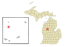
Osceola County Michigan Incorporated and Unincorporated areas LeRoy Highlighted.svg
Location of LeRoy, Michigan
Coordinates: 44°2′16″N85°27′10″W / 44.03778°N 85.45278°W / 44.03778; -85.45278
Country United States
State Michigan
County Osceola
Area
[1]
  Total0.98 sq mi (2.55 km2)
  Land0.98 sq mi (2.55 km2)
  Water0.00 sq mi (0.00 km2)
Elevation
1,260 ft (384 m)
Population
 (2020)
  Total260
  Density264.50/sq mi (102.15/km2)
Time zone UTC-5 (Eastern (EST))
  Summer (DST) UTC-4 (EDT)
ZIP code
49655
Area code 231
FIPS code 26-47100 [2]
GNIS feature ID0630237 [3]
Website http://www.leroymichigan.org/

LeRoy is a village in Osceola County of the U.S. state of Michigan. The population was 256 at the 2010 census. The village is located within LeRoy Township.

Contents

History

A post office in LeRoy has been in operation since 1871, with James E. Bevins serving as postmaster from 1871 to 1895. [4] In 1871 S.L. Kimball, M. Westfall and James Bevins settled in the area, [5] the village of LeRoy was established February 2, 1873, and incorporated in 1883. [6] The village was named for LeRoy Carr, a land agent representing the federal government in the area. [7] [8]

Geography

According to the United States Census Bureau, the village has a total area of 0.97 square miles (2.51 km2), all land. [9]

Demographics

Historical population
CensusPop.Note
1880 134
1890 452237.3%
1900 375−17.0%
1910 331−11.7%
1920 64294.0%
1930 270−57.9%
1940 2741.5%
1950 243−11.3%
1960 2679.9%
1970 248−7.1%
1980 29318.1%
1990 251−14.3%
2000 2676.4%
2010 256−4.1%
2020 2601.6%
U.S. Decennial Census [10]

2010 census

As of the census [11] of 2010, there were 256 people, 97 households, and 68 families residing in the village. The population density was 263.9 inhabitants per square mile (101.9/km2). There were 111 housing units at an average density of 114.4 per square mile (44.2/km2). The racial makeup of the village was 96.1% White, 1.6% African American, 0.8% Native American, and 1.6% from two or more races.

There were 97 households, of which 35.1% had children under the age of 18 living with them, 61.9% were married couples living together, 7.2% had a female householder with no husband present, 1.0% had a male householder with no wife present, and 29.9% were non-families. 23.7% of all households were made up of individuals, and 9.3% had someone living alone who was 65 years of age or older. The average household size was 2.64 and the average family size was 3.10.

The median age in the village was 39.6 years. 25.8% of residents were under the age of 18; 7% were between the ages of 18 and 24; 25% were from 25 to 44; 25.8% were from 45 to 64; and 16.4% were 65 years of age or older. The gender makeup of the village was 48.8% male and 51.2% female.

2000 census

As of the census [2] of 2000, there were 267 people, 100 households, and 74 families residing in the village. The population density was 275.1 inhabitants per square mile (106.2/km2). There were 106 housing units at an average density of 109.2 per square mile (42.2/km2). The racial makeup of the village was 97.75% White, 0.37% Asian, and 1.87% from two or more races.

There were 100 households, out of which 44.0% had children under the age of 18 living with them, 62.0% were married couples living together, 9.0% had a female householder with no husband present, and 26.0% were non-families. 26.0% of all households were made up of individuals, and 13.0% had someone living alone who was 65 years of age or older. The average household size was 2.67 and the average family size was 3.18.

In the village, the population was spread out, with 30.7% under the age of 18, 6.4% from 18 to 24, 30.0% from 25 to 44, 21.3% from 45 to 64, and 11.6% who were 65 years of age or older. The median age was 35 years. For every 100 females, there were 74.5 males. For every 100 females age 18 and over, there were 77.9 males.

The median income for a household in the village was $32,188, and the median income for a family was $40,694. Males had a median income of $27,500 versus $23,750 for females. The per capita income for the village was $13,434. About 4.1% of families and 7.9% of the population were below the poverty line, including 12.6% of those under the age of eighteen and 12.5% of those 65 or over.

Notable people

Related Research Articles

<span class="mw-page-title-main">Concord, Alabama</span> CDP in Alabama, United States

Concord is a census-designated place in Jefferson County, Alabama, United States. At the 2010 census the population was 1,837, up from 1,809 in 2000. It is northwest from the Birmingham suburb of Hueytown.

<span class="mw-page-title-main">East Bronson, Florida</span> Census-designated place in Florida, United States

East Bronson is a census-designated place (CDP) in Levy County, Florida, United States. The population was 1,945 at the 2010 census.

<span class="mw-page-title-main">Stateline, Idaho</span> City in Idaho, United States

Stateline, officially the City of State Line, and historically known as State Line Village, is a city in Kootenai County, Idaho, United States, and is both the easternmost suburb of Spokane, Washington and the westernmost suburb of Coeur d'Alene, Idaho. The population was 38 at the 2010 census. The city is known for the adult services it provides which attract business from nearby Spokane and Coeur d'Alene. The unincorporated community of Spokane Bridge, Washington is located across the Spokane River to the southwest.

<span class="mw-page-title-main">Ingalls, Kansas</span> City in Gray County, Kansas

Ingalls is a city in Gray County, Kansas, United States. As of the 2020 census, the population of the city was 252.

<span class="mw-page-title-main">Michiana, Michigan</span> Village in Michigan, United States

Michiana is a village in New Buffalo Township, Berrien County in the extreme southwest corner of the U.S. state of Michigan. The population was 182 at the 2010 census.

<span class="mw-page-title-main">Shoreham, Michigan</span> Village in Michigan, United States

Shoreham is a village in Berrien County in the U.S. state of Michigan. The population was 844 at the 2020 census. The village is located within St. Joseph Charter Township on the shore of Lake Michigan, just south of the City of St. Joseph.

<span class="mw-page-title-main">Pigeon, Michigan</span> Village in Michigan, United States

Pigeon is a village in Huron County in the U.S. state of Michigan. The population was 1,208 at the 2010 census. The village is within Winsor Township.

<span class="mw-page-title-main">Webberville, Michigan</span> Village in Michigan, United States

Webberville is a village in Ingham County in the U.S. state of Michigan. It is located within Leroy Township. The population was 1,288 at the 2020 census.

<span class="mw-page-title-main">Lakewood Club, Michigan</span> Village in Michigan, United States

Lakewood Club is a village in Dalton Township of Muskegon County in the U.S. state of Michigan. The population was 1,291 at the 2010 census.

<span class="mw-page-title-main">Prescott, Michigan</span> Village in Michigan, United States

Prescott is a village in Ogemaw County of the U.S. state of Michigan. The population was 266 at the 2010 census. The village is located within Richland Township.

LeRoy Township is a civil township of Osceola County in the U.S. state of Michigan. The population was 1,159 at the 2000 census. The Village of LeRoy is located within the township.

<span class="mw-page-title-main">Spring Lake, Michigan</span> Village in Michigan, United States

Spring Lake is a village in Ottawa County in the U.S. state of Michigan. The population was 2,497 at the 2020 census. The village is located within Spring Lake Township.

<span class="mw-page-title-main">Breedsville, Michigan</span> Village in Michigan, United States

Breedsville is a village in Van Buren County of the U.S. state of Michigan. The population was 199 at the 2010 census. The village is within Columbia Township.

<span class="mw-page-title-main">Buckley, Michigan</span> Village in Michigan, United States

Buckley is a village in Wexford County in the U.S. state of Michigan. The population was 775 at the 2020 census. The village is located within Hanover Township.

<span class="mw-page-title-main">Lakeline, Ohio</span> Village in Ohio, United States

Lakeline is a village in Lake County, Ohio, United States. The population was 216 at the 2020 census.

<span class="mw-page-title-main">Terrace Heights, Washington</span> CDP in Washington, United States

Terrace Heights is a census-designated place (CDP) in Yakima County, Washington, United States. The population was 6,937 at the 2010 census. It is essentially a suburb of the city of Yakima.

<span class="mw-page-title-main">Clover, Wisconsin</span> Town in Wisconsin, United States

Clover is a town in Bayfield County, Wisconsin, United States. The population was 223 at the 2010 census. The unincorporated communities of Bark Point and Herbster are located in the town.

<span class="mw-page-title-main">Hubbardston, Michigan</span> Village in Michigan, United States

Hubbardston is a village in the U.S. state of Michigan. It is mostly in North Plains Township in Ionia County, and partially in Lebanon Township in Clinton County. Its population was 395 at the 2010 census.

Lennon is a village in the U.S. state of Michigan. The population was 511 at the 2010 census. The village is located along M-13 within Venice Township in Shiawassee County to the west and Clayton Township in Genesee County to the east.

<span class="mw-page-title-main">Casnovia, Michigan</span> Village in Michigan, United States

Casnovia is a village in the U.S. state of Michigan. It is situated on the boundary between Muskegon and Kent counties and lies partially within both. The population was 319 at the 2010 census. The village is located partially within Tyrone Township.

References

  1. "2020 U.S. Gazetteer Files". United States Census Bureau. Retrieved May 21, 2022.
  2. 1 2 "U.S. Census website". United States Census Bureau . Retrieved January 31, 2008.
  3. U.S. Geological Survey Geographic Names Information System: LeRoy, Michigan
  4. "Chronicles of LeRoy". LeRoy Historical Society. 1999. p. 4.
  5. "Chronicles of LeRoy". LeRoy Historical Society. 1999. p. 1.
  6. "LeRoy Michigan Official Website".
  7. State of Michigan, Michigan 192nd Legislature (July 17, 1973). "A Concurrent Resolution Commemorating the LeRoy Centennial". Letter to Village Fathers of LeRoy.
  8. "Chronicles of LeRoy". LeRoy Historical Society. 1999. p. 37.
  9. "US Gazetteer files 2010". United States Census Bureau. Archived from the original on January 25, 2012. Retrieved November 25, 2012.
  10. "Census of Population and Housing". Census.gov. Retrieved June 4, 2015.
  11. "U.S. Census website". United States Census Bureau . Retrieved November 25, 2012.

44°02′17″N85°27′14″W / 44.03806°N 85.45389°W / 44.03806; -85.45389