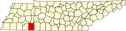
Lebanon, Hardin County, Tennessee | |
|---|---|
 Lebanon  Lebanon | |
| Coordinates: 35°22′12″N88°17′38″W / 35.37000°N 88.29389°W | |
| Country | United States |
| State | Tennessee |
| County | Hardin |
| Elevation | 505 ft (154 m) |
| Time zone | UTC-6 (Central (CST)) |
| • Summer (DST) | UTC-5 (CDT) |
| Area code | 731 |
| GNIS feature ID | 1290900 [1] |
Lebanon is an unincorporated community in Hardin County, Tennessee. Lebanon is located at the intersection of Tennessee State Route 69 and Tennessee State Route 421 east of Milledgeville.