This article needs additional citations for verification .(December 2021) |

Ledburn is a hamlet in the parish of Mentmore, in Buckinghamshire, England.
This article needs additional citations for verification .(December 2021) |
Ledburn is a hamlet in the parish of Mentmore, in Buckinghamshire, England.
The name Ledburn is Anglo Saxon in origin, and means "stream with a conduit". In manorial records of 1212 it was recorded as "Leteburn".
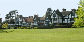
The hamlet consists of two roads with a mixture of Victorian cottages and modern houses, a public house (The Hare) which was converted to private dwellings in 2016, two 16th century farm houses and a manor house. Ledburn Manor was built in the 16th century, and in the early 18th century it was given a new front facade in the classical style.
During the 19th and 20th century, the hamlet was owned by Baron Mayer de Rothschild and, by inheritance, became part of the Earl of Rosebery's Mentmore estate. The manor house at that time served as the estate office and home of the resident Land Agent. A tiny Methodist chapel in the hamlet has recently been converted to a private house.
The agricultural land in the village, having passed out of the Rothschild's ownership in the 20th century, is now back in the family's ownership, and is part of Sir Evelyn de Rothschild's Ascott Estate.
Ledburn was the scene of the so-called Great Train Robbery, in which a £2.6 million train robbery was committed at Bridego Railway Bridge (Bridge Number 127) on 8 August 1963. [2]

Battersea is a large district of south London, England, in the London Borough of Wandsworth. It is centred 3.5 miles (5.6 km) southwest of Charing Cross and extends along the south bank of the River Thames. It includes the 200-acre (0.81 km2) Battersea Park.

Cheddington is a village and civil parish in the Aylesbury Vale district of Buckinghamshire. The parish has an area of 1,429 acres (578 ha). The village is about 6 miles north-east of Aylesbury and three miles north of Tring in Hertfordshire. The hamlet of Cooks Wharf has grown up where the main road into the village from Pitstone crosses the Grand Union Canal.

Waddesdon is a village in Buckinghamshire, England, 6 miles (10 km) west-north-west of Aylesbury on the A41 road. The centre of a civil parish, which also includes the hamlets of Eythrope and Wormstone, Waddesdon was an agricultural settlement with milling, silk weaving and lace making enterprises.

Crafton is a hamlet in the civil parish of Mentmore, in Buckinghamshire, England.

Eythrope is a hamlet and country house in the parish of Waddesdon, in Buckinghamshire, England. It is located to the south east of the main village of Waddesdon. It was bought in the 1870s by a branch of the Rothschild family, and belongs to them to this day.

Ascott House, sometimes referred to as simply Ascott, is a Grade II* listed building in the hamlet of Ascott near Wing in Buckinghamshire, England. It is set in a 32 acre / 13 hectare estate.

Mentmore is a village and civil parish in the Aylesbury Vale district of Buckinghamshire, England. It is about three miles east of Wingrave, three miles south east of Wing.

Mentmore Towers, historically known simply as "Mentmore", is a 19th-century English country house built between 1852 and 1854 for the Rothschild family in the village of Mentmore in Buckinghamshire. Sir Joseph Paxton and his son-in-law, George Henry Stokes, designed the building in the 19th-century revival of late 16th and early 17th-century Elizabethan and Jacobean styles called Jacobethan. The house was designed for the banker and collector of fine art Baron Mayer de Rothschild as a country home, and as a display case for his collection of fine art. The mansion has been described as one of the greatest houses of the Victorian era. Mentmore was inherited by Hannah Primrose, Countess of Rosebery, née Rothschild, and owned by her descendants, the Earls of Rosebery.

Slapton is a village and also a civil parish within Aylesbury Vale district in Buckinghamshire, England. It is located between the Grand Union Canal and the boundary with Bedfordshire, about 3 mi (5 km) south of Leighton Buzzard and 3 mi (5 km) west of Edlesborough.

Wingrave is a village in Buckinghamshire, England, about four miles north east of Aylesbury and three miles south west of Wing.

Halton House is a country house in the Chiltern Hills above the village of Halton in Buckinghamshire, England. It was built for Alfred Freiherr de Rothschild between 1880 and 1883. It is currently used as the main officers' mess for RAF Halton. It is listed Grade II* on the National Heritage List for England.
George Devey was an English architect notable for his work on country houses and their estates, especially those belonging to the Rothschild family. The second son of Frederick and Ann Devey, he was born and educated in London.

Shackleford is a village and civil parish in the Borough of Guildford, Surrey, England centred to the west of the A3 between Guildford and Petersfield 32 miles (51 km) southwest of London and 5.2 miles (8.4 km) southwest of Guildford. Shackleford includes the localities of Eashing, Hurtmore, Norney and Gatwick.

Bentworth is a village and civil parish in the East Hampshire district of Hampshire, England. The nearest town is Alton, which lies about 3 miles (5 km) east of the village. The parish covers an area of 3,763 acres (15.23 km2) and at its highest point is King's Hill, 716 feet (218 m) above sea level. According to the 2011 census, Bentworth had a population of 553. It lies on the edge of the East Hampshire Hangers.

Gunnersbury Park is a park in the London Borough of Hounslow between Acton, Brentford, Chiswick and Ealing, West London, England. Purchased for the nation from the Rothschild family, it was opened to the public by Neville Chamberlain, then Minister of Health, on 21 May 1926. The park is currently jointly managed by Hounslow and Ealing borough councils. A major restoration project funded by the Heritage Lottery Fund was completed in 2018. The park and garden is Grade II listed.
The Rothschild banking family of England was founded in (1798) by Nathan Mayer von Rothschild (1777–1836) who first settled in Manchester but then moved to London. Nathan was sent there from his home in Frankfurt by his father, Mayer Amschel Rothschild (1744–1812). Wanting his sons to succeed on their own and to expand the family business across Europe, Mayer Amschel Rothschild had his eldest son remain in Frankfurt, while his four other sons were sent to different European cities to establish a financial institution to invest in business and provide banking services. Nathan Mayer von Rothschild, the third son, first established a textile jobbing business in Manchester and from there went on to establish N M Rothschild & Sons bank in London.

Burwood Park is an historic estate in the parish of Hersham in Surrey, England. The old mansion house has been demolished and much of the parkland built over to form approximately 400 large detached houses dating from the early 20th century to the present day. The new estate's roads are of a geometric design within an approximate semicircle and many of its roads have entrances with automatic bollards or security buildings.

Westcott railway station was a small station built to serve the village of Westcott, Buckinghamshire, and nearby buildings attached to Baron Ferdinand de Rothschild's estate at Waddesdon Manor. It was built by the Duke of Buckingham in 1871 as part of a short horse-drawn tramway to allow for the transport of goods from and around his extensive estates in Buckinghamshire and to connect the Duke's estates to the Aylesbury and Buckingham Railway at Quainton Road. A lobbying campaign by residents of the town of Brill led to the tramway being converted for passenger use and extended to Brill railway station in 1872, becoming known as the Brill Tramway.

Waddesdon Road railway station, called Waddesdon railway station before 1922, was a small halt in open countryside in Buckinghamshire, England. It was opened in 1871 as part of a short horse-drawn tramway to assist with the transport of goods from and around the Duke of Buckingham's extensive estates in Buckinghamshire and to connect the Duke's estates to the Aylesbury and Buckingham Railway at Quainton Road. In 1872 the line was expanded and converted for passenger use, becoming known as the Brill Tramway. In 1899 the operation of the line was taken over by the London-based Metropolitan Railway.

Eia or Eye was an early Medieval manor in the parish of Westminster, Middlesex and is now a part of Central London. It was about one mile west of the Palace of Westminster/Whitehall, about 2 miles west-south-west of the walled City of London, and about half a mile north of the River Thames. A smaller sub-manor called Ebury or Eybury, containing the hamlet Eye Cross, was originally part of the manor. Ebury and a corruption of it, Avery, appear as modern streets and other places.
Coordinates: 51°53′N0°41′W / 51.883°N 0.683°W
