Soulbury

Last updated

Soulbury
All Saints Church Soulbury - geograph.org.uk - 350157.jpg
All Saints' Church
Soulbury Three Locks - geograph.org.uk - 594.jpg
Soulbury Three Locks
Buckinghamshire UK location map.svg
Red pog.svg
Soulbury
Location within Buckinghamshire
Population736 (2011 census) [1]
OS grid reference SP885275
Civil parish
  • Soulbury
Unitary authority
Ceremonial county
Region
Country England
Sovereign state United Kingdom
Post town LEIGHTON BUZZARD
Postcode district LU7
Dialling code 01525
Police Thames Valley
Fire Buckinghamshire
Ambulance South Central
UK Parliament
List of places
UK
England
Buckinghamshire
51°56′11″N0°43′06″W / 51.9363°N 0.7183°W / 51.9363; -0.7183

Soulbury is a village and also a civil parish within the unitary authority area of Buckinghamshire, England. It is located in the Aylesbury Vale, about seven miles south of Central Milton Keynes, and three miles north of Wing. The village name is Anglo Saxon in origin, and means "stronghold in a gully". In the Domesday Book of 1086, the village was recorded as Soleberie.

Contents

The parish

The parish contains the hamlets of:

Other places mentioned in historical records include:

The parish extends as far as Rammamere Farm on Watling Street. Rammamere Heath is managed with King's Wood in Heath and Reach as a nature reserve. [3]

Liscombe Park

A 17th-century mansion, Liscombe Park was originally the seat of the Lovett family, of whom the most famous member was Colonel John Lovett (c. 1660–1710), patron of the Eddystone Lighthouse. The house was rebuilt in the 1920s by the Bonsor family who live there today. The house is built of brick with small turrets and crenelations, in the style of an 18th-century pseudo gothic castle. The interiors are a mixture of panelling and some 18th-century styles. Near to the house is the former much older chapel, this today has been converted to a billiards room. The house is not open to the public, but the gardens are sometimes used for fairs and fetes.

The stable block has been converted to a leisure and health complex, with a polo cross field. There is a riding stables, open to the public, adjacent to the complex.

An early mention of the name as Lyscombe appears in 1418, where Roger Stok and his wife, Sara, lived, suing people from Stewkley (appearing as Stucle) and Burcote. [4]

Soulbury gave its name to Solebury Township, Pennsylvania, which was founded by Quaker settlers from Soulbury.

Glacial erratic rock

Lovett House, Chapel Hill - the stone known as the Soulbury Boot is close to the front of the red car Lovett House, Chapel Hill, Soulbury - geograph-3997650-by-Robin-Webster.jpg
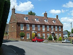
Lovett House, Chapel Hill – the stone known as the Soulbury Boot is close to the front of the red car
The Boot public house. The Boot, Public House, Soulbury - geograph.org.uk - 810085.jpg
The Boot public house.

A glacial erratic lies in a road in the parish. [5] The stone originated in Derbyshire, and was deposited by the retreat of glaciers at the end of the last ice age. Oliver Cromwell is said to have used the stone as a podium during an attack on the village church during the English Civil War. [6] Local tradition holds that the stone is the petrified foot of the devil.

In March 2016, the stone was hit by a motorist who made complaints of it being a hazard, prompting the county council to investigate its removal. The parish council and villagers strongly opposed its removal and the stone still remains in its ancient position. [6] [7]

There is a public house in Soulbury called the Boot. Its pub sign features a boot of the Duke of Wellington, but the tradition of the Soulbury Boot is said to be much older than that. It is said that the Devil himself once came to the village, but the villagers came together to fight him off. One of them took his sword and cut off the Devil's foot and as it fell to the ground it turned to stone. The stone came to be known as the Soulbury Boot. This story is said by some to have been made up by a previous pub landlord in order to attract visitors.

Soulbury Millennium Green

This public greenspace is owned and run by a local charitable trust and was created as part of the celebrations for the turn of the Millennium in the year 2000. It is one of 245 such Millennium Greens throughout England and the only one in Buckinghamshire.[ citation needed ]

Related Research Articles

<span class="mw-page-title-main">Quainton</span> Human settlement in England

Quainton is a village and civil parish in Buckinghamshire, England, 7 miles (11 km) north-west of Aylesbury. The population of the civil parish at the 2011 Census was 1,295. The village has two churches, a school and one public house. The location means that while many commute to London, others are employed in neighbouring towns and villages.

<span class="mw-page-title-main">Flackwell Heath</span> Human settlement in England

Flackwell Heath is a village in the civil parish of Chepping Wycombe on the outskirts of High Wycombe, Buckinghamshire, England. With an elevation of about 150 metres (490 ft), in the Chiltern Hills. It has a population of around 6000.

<span class="mw-page-title-main">Middleton, Milton Keynes</span> Area of Milton Keynes, England

Middleton is an area of Milton Keynes, a city in Buckinghamshire, England, and part of the civil parish of Milton Keynes. Its historic centre is Milton Keynes Village, the village that in 1967 gave its name to the city of which it is now a small part. It is delineated by Childs Way to the north, Tongwell Street to the east, Chaffron Way to the south and Brickhill Street to the west. The River Ouzel runs diagonally through it, from west to north.

<span class="mw-page-title-main">Dagnall</span> Human settlement in England

Dagnall is a village in the parish of Edlesborough, in Buckinghamshire, England.

Great Brickhill is a village and civil parish in the unitary authority area of Buckinghamshire, England. It is on the border with the City of Milton Keynes, located 6 miles (9.7 km) south-east of Central Milton Keynes, and 3 miles (4.8 km) in the same direction from Fenny Stratford.

<span class="mw-page-title-main">Holmer Green</span> Human settlement in England

Holmer Green is a village in the civil parish of Little Missenden, in Buckinghamshire, England. It is next to Hazlemere, about 3 miles (5 km) south of Great Missenden.

<span class="mw-page-title-main">Linslade</span> Human settlement in England

Linslade is a town in the civil parish of Leighton-Linslade, in the Central Bedfordshire unitary authority area of Bedfordshire, England. It borders the town of Leighton Buzzard. Linslade was transferred from Buckinghamshire in 1965. Before then, it was a separate urban district. It remained a part of the Diocese of Oxford until 2008 when it joined Leighton Buzzard in the Diocese of St Albans.

<span class="mw-page-title-main">Oakley, Buckinghamshire</span> Human settlement in England

Oakley is a village and civil parish in Buckinghamshire, England. It has an area of 2,206 acres (893 ha) and includes about 400 households. The 2011 Census recorded the population as 1,007.

<span class="mw-page-title-main">Pitstone</span> Human settlement in England

Pitstone is a village and civil parish in east Buckinghamshire, England. It is at the foot of the central range of the Chiltern Hills, centred 6 miles (10 km) east of Aylesbury and 5 miles (8 km) south of Leighton Buzzard. It directly adjoins the village of Ivinghoe, and the two villages share some facilities.

<span class="mw-page-title-main">Billington, Bedfordshire</span> Human settlement in England

Billington is a civil parish in Bedfordshire about 3 miles (4.8 km) south of Leighton Buzzard and not far from the Buckinghamshire border. There are two settlements: Little Billington and one that is now called Great Billington. At the 2021 census, the parish had a population of 359.

<span class="mw-page-title-main">Wootton, Bedfordshire</span> Human settlement in England

Wootton is a large village and civil parish located to the southwest of Bedford, in the north of Bedfordshire, England. The parish also includes the hamlets of Hall End, Keeley Green and Wootton Green.

<span class="mw-page-title-main">Chrishall</span> Human settlement in England

Chrishall is a small village in the English county of Essex. It is located 12 miles (20 km) south of Cambridge and lies equidistant [6 miles (10 km)] between the two medieval market towns of Saffron Walden and Royston. Although in Essex, Chrishall lies close to its borders with Hertfordshire and Cambridgeshire and has a 'Hertfordshire' postcode (SG8).

<span class="mw-page-title-main">Ashwell, Hertfordshire</span> Human settlement in England

Ashwell is a village and civil parish in Hertfordshire situated 4 miles (6 km) north-east of Baldock.

<span class="mw-page-title-main">Ninfield</span> Village in East Sussex, England

Ninfield is a village and civil parish in the Wealden District of East Sussex, England. The village is quite linear and centred 4 miles (6.4 km) north of Bexhill-on-Sea where two roads cross: the A269 from Bexhill to Battle and the A271 to Hailsham. The parish covers 2,500 acres (1,010 ha); approximately the northern half of which is in the High Weald AONB.

<span class="mw-page-title-main">Silsoe</span> Human settlement in England

Silsoe is a village and civil parish in Bedfordshire, England. The village used to be on the main A6 road but a bypass around the village was opened in 1981 at a cost of £1.6m.

<span class="mw-page-title-main">Stockgrove Country Park</span>

Stockgrove Country Park is located in England on the Bedfordshire/Buckinghamshire border in the parish of Heath and Reach. Stockgrove Park's 80 acres is part of the larger 400 acre woods called Rushmere Country Park, managed by the Greensand Trust. The Greensand Trust manages this area comprising Rushmere, Stockgrove, Oak Wood and Rammamere and parts of Kings Wood. Stockgrove was opened to the public in 1972 and Rushmere is the newest addition to the Estate, opened in 2011. The largest of the lakes features the remains of a boathouse that burned down in 1963 – only its brick arches are left. Mandarin ducks took up residence in 1997 and have bred there ever since. The park is partly in the Kings and Bakers Woods and Heaths Site of Special Scientific Interest.

<span class="mw-page-title-main">Inkberrow</span> Human settlement in England

Inkberrow is a village in Worcestershire, England, often thought to be the model for Ambridge, the setting of BBC Radio 4's long-running series The Archers. In particular, The Bull, the fictional Ambridge pub, is supposed to be based on The Old Bull in Inkberrow.

<span class="mw-page-title-main">Tilsworth</span> Human settlement in England

Tilsworth is a small village and civil parish in Bedfordshire. It lies to the north west of Dunstable, and the Roman Watling Street (A5) forms the north east boundary of the parish of 1,200 acres (4.8 km2). The village lies on the gault clay, where springs well up just south of a gentle gravelly ridge. A large proportion of the area is still farmland.

<span class="mw-page-title-main">Tawstock</span> Village in Devon, England

Tawstock is a village, civil parish and former manor in North Devon in the English county of Devon, England. The parish is surrounded clockwise from the north by the parishes of Barnstaple, Bishop's Tawton, Atherington, Yarnscombe, Horwood, Lovacott and Newton Tracey and Fremington. In 2001 it had a population of 2,093. The estimated population in June 2019 was 2,372.

<span class="mw-page-title-main">Sir Henry Northcote, 4th Baronet</span>

Sir Henry Northcote, 4th Baronet (1655–1730) was an English baronet from Devon. He was by profession a doctor of medicine. His great-great-great-grandson was Stafford Northcote, 1st Earl of Iddesleigh (1818–1887).

References

  1. Neighbourhood Statistics 2011 Census, Accessed 3 February 2013
  2. Plea Rolls of the Court of Common Pleas; CP541; year 1396 first entry; line 5. The defendant is William Holynden; (Hollingdon is near Soulbury), the plaintiff is Roger atte Broke of Steuecle (Stewkley)
  3. Wildlife Trust, King's Wood and Rammamere Heath
  4. "AALT Page". aalt.law.uh.edu. Retrieved 22 July 2020.
  5. Map, The Megalithic Portal and Megalith. "Soulbury Stone". The Megalithic Portal. Retrieved 2 June 2018.
  6. 1 2 Finnigan, Lexi (29 March 2016). "Council bosses threaten to remove ancient stone rock at heart of village". The Telegraph. Retrieved 30 March 2016.
  7. Addley, Esther (2 April 2016). "The Soulbury stone never loses – and now the council knows it". The Guardian. Retrieved 22 July 2020.

Further reading