
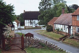
Long Crendon is a village and civil parish in west Buckinghamshire, England, about 3 miles (5 km) west of Haddenham and 2 miles (3 km) north-west of Thame in neighbouring Oxfordshire. The village has been called Long Crendon only since the English Civil War. The "Long" prefix refers to the length of the village at that time, and was added to differentiate it from nearby Grendon Underwood, which used to be known as "Crendon". This name is Old English and means 'Creoda's Hill'.

Stowe is a civil parish and former village about two miles northwest of Buckingham in the unitary authority area of Buckinghamshire, England. The parish includes the hamlets of Boycott, Dadford and Lamport.

Aston Abbotts or Aston Abbots is a village and civil parish in Buckinghamshire, England. It is about 4 miles (6.4 km) north of Aylesbury and 2.5 miles (4 km) south-west of Wing. The parish includes the hamlet of Burston and had a population of 426 at the 2021 Census.

Barton Hartshorn is a civil parish about 4 miles (6.4 km) southwest of Buckingham in Buckinghamshire, within the Buckinghamshire Council unitary authority area. Its southern boundary is a brook called the Birne, and this and the parish's western boundary form part of the county boundary with Oxfordshire. At the 2011 Census the population of the parish was included in the civil parish of Chetwode

Chetwode is a village and civil parish about 4 miles (6.4 km) southwest of Buckingham in the Aylesbury Vale district of Buckinghamshire. The parish is bounded to the southwest and southeast by a brook called The Birne, which here also forms part of the county boundary with Oxfordshire.
Chilton is a village and civil parish in Aylesbury Vale district in Buckinghamshire, England. It is in the west of the county, about 4 miles (6.4 km) north of Thame in Oxfordshire. Chilton parish includes the hamlet of Easington.

Dorton is a village and civil parish in the Aylesbury Vale district of Buckinghamshire. It is in the western part of the county, about 5 miles (8 km) north of the Oxfordshire market town of Thame.

Drayton Parslow is a village and civil parish in Buckinghamshire, England, about 3.5 miles (5.6 km) south of Bletchley, within the Buckinghamshire Council unitary authority area. In the 2001 census the parish had a population of 596, increasing at the 2011 census to 614.
Ickford is a village and civil parish in the unitary authority area of Buckinghamshire, England. It is on the boundary with Oxfordshire, about 4 miles (6.4 km) west of the market town of Thame.

Ilmer is a village and former civil parish, now in the parish of Longwick-cum-Ilmer, in Buckinghamshire, England. It is at the foot of the Chiltern Hills about 3 miles (5 km) northwest of Princes Risborough, near the boundary with Oxfordshire. In 1931 the parish had a population of 40. On 1 April 1934 the parish was abolished to form "Longwick cum Ilmer".

Lillingstone Lovell is a village and civil parish in north Buckinghamshire, England. It is located around 4 miles (6.4 km) north of Buckingham and 8 miles (13 km) west of Milton Keynes, and around 5 miles (8 km) south of Towcester in the neighbouring county of Northamptonshire. Silverstone Circuit is located just over 2 miles (3.2 km) north-west of Lillingstone Lovell.

Little Missenden is a village and civil parish on the River Misbourne in Buckinghamshire, England. It is in the Chiltern Hills, about 3 miles (5 km) southeast of Great Missenden and 3 miles (5 km) west of Amersham. The village lies on the River Misbourne in the Misbourne valley.
Pitchcott is a village and civil parish in the Aylesbury Vale district of Buckinghamshire, England. It is about 3 miles (5 km) north-east of Waddesdon, slightly less than 4 miles (6.4 km) south of Winslow and slightly more than 4 miles north of Aylesbury. It is in the civil parish of Oving.

Thornton is a village and civil parish on the River Great Ouse about 3.5 miles (5.6 km) north-east of Buckingham in the unitary authority area of Buckinghamshire.

Turweston is a village and civil parish in north-west Buckinghamshire, England. The village is beside the River Great Ouse, which bounds the parish to the north, west and south. Turweston is the most northwesterly parish in Buckinghamshire: the Ouse here forms the county boundary with Northamptonshire to the north and west and Oxfordshire to the south. Across the river, the Northamptonshire market town of Brackley is just west of Turweston, with the town centre about 1 mile (1.6 km) west of the village. The parish has an area of 1,295 acres (524 ha) and had a population of 211 at the 2011 Census.

Water Stratford is a village and civil parish on the River Great Ouse in Buckinghamshire, England. It is about 3 miles (5 km) west of Buckingham, near the boundary with Oxfordshire.

Worminghall is a village and civil parish in the Buckinghamshire district of the ceremonial county of Buckinghamshire, England.
Silverstone is a village and civil parish in Northamptonshire, England. It is about four miles from Towcester on the former A43 main road, 10 miles (16 km) from the M1 motorway junction 15A and about 12 miles (19 km) from the M40 motorway junction 10, Northampton, Milton Keynes and Banbury. The population of the civil parish at the 2011 census was 2,176. The A43 now bypasses to the south-east of the village.

Dry Sandford is a village in the Vale of White Horse district of England, about 3 miles (5 km) north-west of Abingdon. It is one of two villages in the civil parish of St Helen Without. It was part of Berkshire until the 1974 boundary changes transferred the Vale of White Horse to Oxfordshire.
Crowell is a village and civil parish in the South Oxfordshire district, in Oxfordshire, England, about 4 miles (6.4 km) southeast of the market town of Thame and 1 mile (1.6 km) southwest of the village of Chinnor. The 2001 Census recorded the parish's population as 100. Crowell village is a spring line settlement at the source of a stream called the Pleck at the foot of the Chiltern Hills escarpment. The toponym "Crowell" is derived from the Old English for "crow's spring" or "crow's stream".


