
Boarstall is a village and civil parish in the Aylesbury Vale district of Buckinghamshire, about 12 miles (19 km) west of Aylesbury. The parish is on the county boundary with Oxfordshire and the village is about 5.5 miles (9 km) southeast of the Oxfordshire market town of Bicester.
Botolph Claydon is a hamlet in the civil parish of East Claydon, in Buckinghamshire, England. It is situated about 9 miles (14 km) east of Bicester in Oxfordshire, and 7 miles (11 km) north west of Aylesbury.

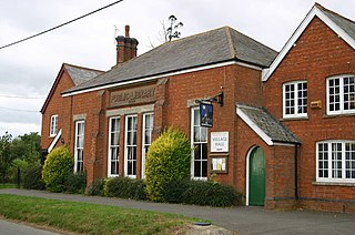
Oakley is a village and civil parish in Buckinghamshire, England. It has an area of 2,206 acres (893 ha) and includes about 400 households. The 2011 Census recorded the population as 1,007.

Abbots Deuglie is a hamlet in Perth and Kinross, Scotland. It is located in the Ochil Hills, in Arngask parish, about one mile (1.5 km) west of Glenfarg. Glenfarg Reservoir lies just to the west of the village, and was built in 1912.

Gaunt's Earthcott, sometimes spelt Gaunts Earthcott, is a hamlet in the civil parish of Almondsbury in South Gloucestershire, England. It consists of a ruined chapel, a few houses and two farms, Green Farm and Court Farm. The village is located approximately 2.5 miles (4 km) from Rudgeway and the A38 road and about the same distance from Frampton Cotterell and Winterbourne. The village is located close to the interchange between the M4 and M5 motorways. There is no real industry as such and the main economic activity in the area is farming.

Beckley and Stowood is a civil parish in South Oxfordshire, England. Its area is 9.17 km2. It is 3 miles (4.8 km) northeast of Oxford and 1 mile (1.6 km) west of the M40. The parish is made up of Beckley and Stowood.

Addingrove is a former hamlet in Buckinghamshire, about 4 miles (6.4 km) northwest of the market town of Thame in neighbouring Oxfordshire. The settlement is on the B4011 road between Oakley and Long Crendon.

Cherwell Valley services is a motorway service station on the M40 motorway at Stoke Lyne, near Bicester, in Oxfordshire, England. In addition to the normal facilities provided by a motorway service station, the site also includes a Travelodge hotel in a separate building, together with a riverside walk.

Finchdean is a rural hamlet in the East Hampshire district of Hampshire, England. It lies on the Hampshire/West Sussex border, 1.7 miles (2.7 km) east of Horndean.
Trench Green is a hamlet in Oxfordshire about 1 mile (1.6 km) northeast of the village of Mapledurham and about 4 miles (6.4 km) northwest of Reading in neighbouring Berkshire. It is situated on the rural road from Caversham to Goring Heath and Goring-on-Thames, at its junction with the access lane to Mapledurham village. For local government purposes Trench Green is in Mapledurham civil parish, which forms part of the district of South Oxfordshire within the county of Oxfordshire. It is within the Henley constituency of the United Kingdom Parliament. Prior to Brexit in 2020, the village was represented by the South East England constituency in the European Parliament. Although barely more than a few houses around the road junction, Trench Green does contain a former school, which is now a house, and the parish's parish hall.
Gosford and Water Eaton is a civil parish in the Cherwell district of the county of Oxfordshire, England. It is north of the city of Oxford and is crossed nearby by two major roads for, or by-passing, the city. The parish contains the village of Gosford and the hamlet of Water Eaton and as at the 2011 census had 1373 people resident across its 8.75 km2.

Brabourne Lees is a village in the civil parish of Brabourne, within the Ashford borough of Kent, England. The village (centre) is just under 5 miles (8 km) east of Ashford town centre itself geographically. By road this is a journey of about 6 miles (10 km). In 2021 it had a population of 1480.

Great Holcombe is a hamlet in Newington civil parish in South Oxfordshire, about 4.5 miles (7.2 km) north of Wallingford.

Chazey Heath is a hamlet in Oxfordshire, England, about 3 miles (4.8 km) north of Reading, Berkshire. It is situated on the A4074 road, between Caversham and Oxford, at its junction with the rural road to Goring Heath and Goring-on-Thames. For local government purposes Chazey Heath is in Mapledurham civil parish, which forms part of the district of South Oxfordshire within the county of Oxfordshire. It is within the Henley constituency of the United Kingdom Parliament. Prior to Brexit in 2020, it was represented by the South East England constituency for the European Parliament.
Old Chalford is a hamlet in Enstone civil parish, about 2 miles (3 km) east of Chipping Norton, Oxfordshire.
Enborne Row is a hamlet in Berkshire, England, located on the county's border with Hampshire. The hamlet is within the civil parish of Enborne. The settlement lies next to the A34 road, and is located approximately 3 miles (4.8 km) south-west of Newbury. The name Enborne comes from Old English and means duck stream.

Goddard's Green is a hamlet and part of the civil parish of Wokefield in Berkshire, England. The settlement lies between the villages of Burghfield Common and Mortimer Common, and is located approximately 5.5 miles (8.9 km) south-east of Reading. The Garth and South Berks Hunt had kennels here until 2002.

Bloomfield Hatch is a hamlet in Berkshire, England, and part of the civil parish of Wokefield. The settlement lies near the villages of Stratfield Mortimer and Beech Hill, and is located approximately 5 miles (8.0 km) south-east of Reading. It is located immediately to the East of Wokefield Park. Bloomfield Hatch Farm lies in the centre of the hamlet.
Fanner's Green is a hamlet and cul-de-sac road in the Great Waltham civil parish of the Chelmsford district of Essex, England. It is situated 1 mile (1.6 km) south-west from the village of Great Waltham. The county town of Chelmsford is approximately 2 miles (3 km) to the south-east. Fanner's Green comprises Fanner's farm, and a barn 200 yards (183 m) south on Breeds Road.
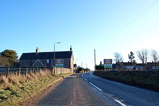
Craichie is a hamlet in the parish of Dunnichen, Angus, Scotland. Craichie is three miles south-east of Forfar and two miles south-west of Letham, at a junction on the B9128 Carnoustie to Forfar road.


