Quainton is a village and civil parish in Buckinghamshire, England, 7 miles (11 km) north-west of Aylesbury. The population of the civil parish at the 2011 Census was 1,295. The village has two churches, a school and one public house. The location means that while many commute to London, others are employed in neighbouring towns and villages.

Chetwode is a village and civil parish about 4 miles (6.4 km) southwest of Buckingham in the Aylesbury Vale district of Buckinghamshire. The parish is bounded to the southwest and southeast by a brook called The Birne, which here also forms part of the county boundary with Oxfordshire.
Cublington is a village and one of 110 civil parishes within Aylesbury Vale district in Buckinghamshire, England. It is about seven miles (11 km) north of Aylesbury. The village name is Anglo Saxon in origin, and means "Cubbel's estate". In the Domesday Book of 1086 it was recorded as Coblincote.

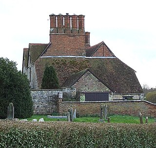
Dorton is a village and civil parish in the Aylesbury Vale district of Buckinghamshire. It is in the western part of the county, about 5 miles (8 km) north of the Oxfordshire market town of Thame.

Dunton is a village and civil parish in the Aylesbury Vale district of Buckinghamshire, England. The village is situated approximately 8 miles (13 km) north from Aylesbury and 4 miles (6.4 km) south-east from Winslow.

Thame is a market town and civil parish in Oxfordshire, about 13 miles (21 km) east of the city of Oxford and 10 miles (16 km) southwest of Aylesbury. It derives its name from the River Thame which flows along the north side of the town and forms part of the county border with Buckinghamshire. The parish includes the hamlet of Moreton south of the town. The 2011 Census recorded the parish's population as 11,561. Thame was founded in the Anglo-Saxon era and was in the kingdom of Wessex.
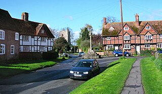
North Marston is a village and also a civil parish in the Buckinghamshire district in the ceremonial county of Buckinghamshire, England. It is located about three miles south of Winslow, and four miles north of Waddesdon.
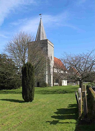
Pitchcott is a village and civil parish in the Aylesbury Vale district of Buckinghamshire, England. It is about 3 miles (5 km) north-east of Waddesdon, slightly less than 4 miles (6.4 km) south of Winslow and slightly more than 4 miles north of Aylesbury. It is in the civil parish of Oving.
Radclive is a village on the River Great Ouse just over 1 mile (1.6 km) west of Buckingham in Buckinghamshire, England. It is in the civil parish of Radclive-cum-Chackmore in Aylesbury Vale district. The parish includes the hamlet of Chackmore about 1.5 miles (2.4 km) north of Buckingham.
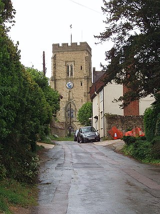
Whitchurch is a village and civil parish in the unitary authority area of Buckinghamshire, England. The village is on the A413 road about 4 miles (6.4 km) north of Aylesbury and 4.5 miles (7 km) south of Winslow. The 2011 Census recorded a parish population of 932.

Yelling is a linear village and civil parish in the Huntingdonshire administrative district of Cambridgeshire, England. The village is about 5 miles (8 km) east of St Neots and 6 miles (10 km) south of Huntingdon.
Binsted is a village and large civil parish in East Hampshire, England. It is about 4.1 miles (6.6 km) east of Alton, its nearest town. The parish is one of the largest in northern Hampshire and covers almost 7,000 acres (2,800 ha). It contains two villages, Bucks Horn Oak and Holt Pound, as well as two hamlets, Wyck and Wheatley. The parish also covers the entirety of the Alice Holt Forest, a royal forest situated near the border with Surrey. The nearest railway station is 1.8 miles (2.9 km) northeast of the village, at Bentley. According to the 2011 census, the parish had a population of 1,817 people.
East Hagbourne is a village and civil parish about 1 mile (1.6 km) south of Didcot and 11 miles (18 km) south of Oxford. It was part of Berkshire until the 1974 boundary changes transferred it to Oxfordshire. The 2011 Census recorded the parish's population as 1,882.

Woodeaton or Wood Eaton is a village and civil parish about 4 miles (6.4 km) northeast of Oxford, England. It also has a special needs school called Woodeaton Manor School.

Britford is a village and civil parish beside the River Avon about 1.5 miles (2.4 km) south-east of Salisbury in Wiltshire, England. The village is just off the A338 Salisbury-Bournemouth road. The 2011 Census recorded a parish population of 592.

Seend is a village and civil parish about 3 miles (5 km) southeast of the market town of Melksham, Wiltshire, England. It lies about 3.5 miles (6 km) west of Devizes and 5.5 miles (9 km) northeast of the county town of Trowbridge. The parish includes the sub-village of Seend Cleeve and the hamlets of Inmarsh, Martinslade, Seend Head, Sells Green and The Stocks.
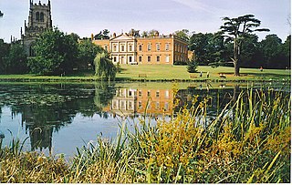
Staunton Harold is a civil parish in North West Leicestershire about 3 miles (5 km) north of Ashby-de-la-Zouch. The parish is on the county boundary with Derbyshire and about 9 miles (14 km) south of Derby. The 2011 Census recorded the parish's population as 141.

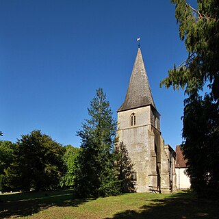
Seckington is a village and civil parish in North Warwickshire, about 4 miles (6 km) northeast of Tamworth. The B4593 road between Tamworth and Appleby Magna runs through the parish, passing about 100 yards (91 m) north of the village. Seckington shares a parish council with Newton Regis and No Man's Heath. Forming part of the border with Staffordshire, it is the second most northerly settlement in Warwickshire, with only No Man's Heath situated further north, and is only 3.5 miles due south of the Derbyshire border.
Sparsholt is a village and civil parish about 3 miles (5 km) west of Wantage in the Vale of White Horse district of Oxfordshire. The parish includes the hamlet of Westcot about 1⁄2 mile (800 m) west of the village. Sparsholt was part of Berkshire until the 1974 boundary changes transferred the Vale of White Horse to Oxfordshire.

Wilcot is a village and former civil parish, now in the parish of Wilcot, Huish and Oare, in Wiltshire, England, in the Vale of Pewsey about 6 miles (10 km) southwest of Marlborough and 1.5 mi (2.4 km) northwest of Pewsey. In 2011 the parish had a population of 558.