
Stanbury is a village in the Haworth, Cross Roads and Stanbury civil parish, and in the metropolitan borough of the City of Bradford in West Yorkshire, England. The name Stanbury translates as Stone Fort from Old English.

Dadford is a hamlet in the parish of Stowe, north Buckinghamshire, England.

Burcott is a hamlet in the parish of Bierton with Broughton, Buckinghamshire, England.

Ascott is a hamlet and country house in the parish of Wing, Buckinghamshire, England. The hamlet lies completely within the boundary of the Ascott Estate; it is home to many of the estate and house staff.

Bledlow Ridge is a village in the civil parish of Bledlow-cum-Saunderton in Buckinghamshire, England. In 2004 the population was 940. It is situated in the Chiltern Hills, about 4 miles SSW of Princes Risborough and on the road between the High Wycombe and Chinnor.

Botley is a hamlet in the civil parish of Chesham, in Buckinghamshire, England.

Crafton is a hamlet in the civil parish of Mentmore, in Buckinghamshire, England.

Soulbury is a village and also a civil parish within the unitary authority area of Buckinghamshire, England. It is located in the Aylesbury Vale, about seven miles south of Central Milton Keynes, and three miles north of Wing. The village name is Anglo Saxon in origin, and means "stronghold in a gully". In the Domesday Book of 1086, the village was recorded as Soleberie.

Flimwell is a village in the civil parish of Ticehurst, in the Rother district of East Sussex, England. It is located about two miles from the village of Ticehurst, close to the border with Kent. The village is located at a busy crossroads on the A21 road where two roads — the A268 to Hawkhurst and a secondary road, the B2087 — cross it.

Mynydd Isa[ˌmənɨ̞ð ˈɪsa] is a village in Flintshire, in north-east Wales. It lies between the county town of Mold, and Buckley in the community of Argoed which had a population of 5837 according to the 2011 census. Mynydd Isa was originally a small hamlet on the north side of the Mold to Buckley road just downhill from the now demolished Calvinist chapel. It did not appear on Ordnance Survey maps until 1912.
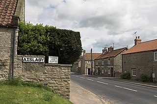
Aislaby is a hamlet and civil parish near the English town of Pickering, North Yorkshire. It lies on the A170 to the west of Pickering between Wrelton and Middleton.

Barrow is a civil parish, in the unitary authority of Cheshire West and Chester and the ceremonial county of Cheshire, England. The civil parish contains the village of Great Barrow and the hamlets of Little Barrow, Broomhill and Stamford Bridge. Great Barrow is situated about 4.5 miles east-north-east of Chester, 6 miles north-west of Tarporley and 6 miles south of Frodsham.

Finchdean is a rural hamlet in the East Hampshire district of Hampshire, England. It lies on the Hampshire/West Sussex border, 1.7 miles (2.7 km) east of Horndean.

Denton is a hamlet and civil parish in the Harrogate district of North Yorkshire, England. At the 2011 Census the population of this civil parish was less than 100. Details are included in the civil parish of Middleton, Harrogate. It is situated 1 mile (1.6 km) north-east of Ilkley, West Yorkshire. Denton Hall is located in the hamlet.

Ashley is a hamlet located in the parish of Sutton, some five miles (8 km) north of Dover on the summit of Gaggs Hill in Kent, England. Ashley runs almost seamlessly into the neighbouring village of Studdal. The A256 road passes to the west of Ashley. The population of the hamlet is included in the civil parish of Tilmanstone.

Bow Street is a large village in the Tirymynach district of Ceredigion, Wales, approximately 3.5 miles (5.6 km) north-east of Aberystwyth. As well as Bow Street itself, it is now often considered to include the neighbouring smaller village of Pen-y-garn and the hamlet of Rhydypennau. All three places stretch in a long narrow strip along the main Aberystwyth to Machynlleth road, the (A487).
Enborne Row is a hamlet in Berkshire, England, located on the county's border with Hampshire. The hamlet is within the civil parish of Enborne. The settlement lies next to the A34 road, and is located approximately 3 miles (4.8 km) south-west of Newbury.
Downham West is a civil parish in the English county of Norfolk The parish is 47.6 miles (76.6 km) west of Norwich, 16.3 miles (26.2 km) south-south-west of King's Lynn and 96.2 miles (154.8 km) north of London. The nearest town is Downham Market which is 2.5 miles (4.0 km) north east of the parish. The nearest railway station is at Downham Market for the Fen Line which runs between King's Lynn and Cambridge. The nearest airport is Norwich International Airport. The parish of Downham West, in the 2001 census, has a population of 285, rising marginally to 286 at the Census 2011. For the purposes of local government, the parish falls within the district of King's Lynn and West Norfolk.

Potterton is a hamlet 1 mile (1.5 km) north of Barwick-in-Elmet in City of Leeds, West Yorkshire, England. The hamlet falls within the Harewood ward of the Leeds Metropolitan Council. The hamlet is just south of the A64 road and so has access to junction 44 of the A1(M) motorway 2.5 miles (4 km) away with Leeds being only 7 miles (11 km) to the west.

Ryecroft is a hamlet near to the village of Harden in West Yorkshire, England. The hamlet is on the road between Harden and Haworth, 1.9 miles (3 km) south of Keighley, 1.9 miles (3 km) west of Bingley and 0.6 miles (1 km) west of the centre of Harden.


