Makian, known to local people as Mount Kie Besi, is a volcanic island, one of the Maluku Islands within the province of North Maluku in Indonesia. It lies near the southern end of a chain of volcanic islands off the western coast of the province's major island, Halmahera, and lies between the islands of Tidore to the north and Kayoa and the Bacan Group to the south. The island, which forms a district within South Halmahera Regency of North Maluku Province, covers an area of 84.36 sq.km, and had a population of 12,394 at the 2010 Census, which rose to 14,000 at the 2020 Census.

Seram is the largest and main island of Maluku province of Indonesia, despite Ambon Island's historical importance. It is located just north of the smaller Ambon Island and a few other adjacent islands, such as Saparua, Haruku, Nusa Laut and the Banda Islands.

The Barat Daya Islands are a group of islands in the Maluku province of Indonesia. The Indonesian phrase barat daya means 'south-west'.

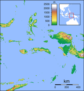
West Papua, formerly Irian Jaya Barat or Irian Barat, is a province of Indonesia. It covers the two western peninsulas of the island of New Guinea, Bird's Head Peninsula and Bomberai Peninsula, along with nearby islands. The province is bordered to the north by the Pacific Ocean, to the west by the Halmahera Sea and the Ceram Sea, to the south by the Banda Sea, and to the east by the province of Papua and the Cenderawasih Bay. Manokwari is the province's capital, while Sorong is its largest city. West Papua is the second-least populous province in Indonesia, with a population of 1,134,068 at the 2020 Census.

Maluku is a province of Indonesia. It comprises the central and southern regions of the Maluku Islands. The main city and capital of Maluku province is Ambon on the small Ambon Island. The land area is 62,946 km2, and the total population of this province at the 2010 census was 1,533,506 people, rising to 1,848,923 at the 2020 Census. Maluku is located in Eastern Indonesia. It is directly adjacent to North Maluku and West Papua in the north, Central Sulawesi, and Southeast Sulawesi in the west, Banda Sea, East Timor and East Nusa Tenggara in the south and Arafura Sea and Papua in the east.
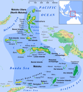
The Obi Islands are a group of 42 islands in the Indonesian province of North Maluku. They lie north of Buru and Ceram. They cover a land area of 3,048.08 km2, and had a population of 41,455 at the 2010 Census, which had risen to 50,760 at the 2020 Census.
Wetar is a tropical island which belongs to the Indonesian province of Maluku and is the largest island of the Maluku Barat Daya Islands of the Maluku Islands. It lies east of the Lesser Sunda Islands, which include nearby Alor and Timor, but it is politically part of the Maluku Islands. To the south, across the Wetar Strait, lies the island of Timor; at its closest it is 50 km away. To the west, across the Ombai Strait, lies the island of Alor. To the southwest is the very small island of Liran, which is also part of Wetar district (kecamatan) and, further southwest, the small East Timorese island of Atauro. To the north is the Banda Sea and to the east lie Romang and Damar Islands, while to the southeast lie the other principal islands of the Barat Daya Islands. Including Liran, Wetar has an area of 2,651.9 km2, and had a population of 7,916 at the 2010 Census.
Liran is a small island off the southwest coast of Wetar Island, Indonesia. Administratively it is part of West Wetar District within the Southwest Maluku Regency. The East Timorese island Atauro is 12 km to the southwest. Liran is the westernmost of the Barat Daya Islands in the province of Maluku. It covers an area of 39.14 km2 and had 841 inhabitants in 2019.

Romang is an island, part of Barat Daya Islands in Indonesia, located at 7.5833333°S 127.4333333°E, east of Wetar Island. Alternate names in use are Roma, Romonu and Fataluku. It is included within the Terselatan Islands District within the Barat Daya Islands Regency of the Maluku Province; the District also includes the smaller Kisar Island further south.

Southwest Aceh Regency is a regency in the Aceh special region of Indonesia. It is located on the island of Sumatra. The regency covers an area of 1,882.05 square kilometres and according to the 2010 census had a population of 126,036; this rose to 140,366 at the 2015 Census, and to 150,775 at the 2020 Census. The seat of the regency government is at Blangpidie.
Southwest Sumba Regency is a regency on Sumba Island in East Nusa Tenggara province of Indonesia. Established in 2007, the regency has its seat (capital) in Tambolaka. Its population was 283,818 in the 2010 decennial census and had risen to 303,650 at the 2020 Census, comprising 155,716 male and 147,934 female.
West Halmahera Regency is a regency in North Maluku Province, Indonesia. It covers an area of 2,080.21 km2, and it had a population of 100,424 people at the 2010 Census and 132,349 at the 2020 Census. The capital lies at Jailolo.

South Halmahera Regency is a regency of North Maluku Province, Indonesia. It lies partly on Halmahera Island and partly on smaller islands to the west and south of Halmahera. It covers a land area of 8,779.320 km2, and at the 2010 Census it had a population of 198,911 people, while the 2020 Census showed that this had risen to 248,395. The capital lies at the town of Labuha on Bacan Island.

Southeast Maluku Regency is a regency of Maluku, Indonesia. It is coincident with the Kei Islands, except that the city of Tual, although within the Kei Islands geographically and the seat of the Regency's administration, is technically independent of the Regency. The land area of the Regency is 1,031.81 km2, while the sea area administered by the regency was 3,181 km2; it had a population of 96,442 at the 2010 Census; this increased to 127,843 at the 2020 Census. The capital is located in Langgur.

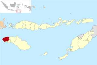
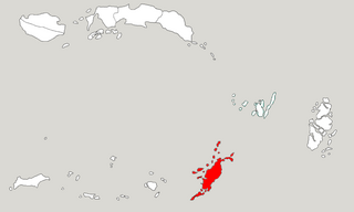
Southwest Maluku Regency is a regency of Maluku Province, Indonesia. It comprises a number of islands and island groups in the south of the province, including Lirang Island, Wetar Island, Kisar Island, Romang Island, the Letti Islands, the Damer Islands, Mdona Hyera and the Babar Islands. The administrative centre lies at Tiakur on Moa Island, but the largest town is Wonreli.
Tanimbar Islands Regency is a regency of Maluku province, Indonesia, consisting primarily of the Tanimbar Islands. The Regency covers a land area of 10,102 km2, and it had a population of 105,341 at the 2010 Census and 123,572 at the 2020 Census. The principal town and administrative centre lies at Saumlaki.

Leti is an Indonesian island, the westernmost of the Leti Islands, and one of the 92 officially listed outlying islands of Indonesia. Leti is located in southwest Maluku province. The main town is Sewaru.
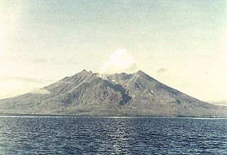
Damer, or Damar, is a small volcanic island in the Barat Daya Islands group in Indonesia's Maluku province, on the southern side of the Banda Sea. It is flanked by four smaller islands - one to the east, one to the west and two to the south. Together they are called the Damar Islands, and constitute one administrative district within the Maluku Barat Daya Regency. The district has a land area of 392.29 km2 and had a population of 5,718 at the 2020 Census.
Moa is an Indonesian island, at the center of the Leti Islands, and one of the 92 officially listed outlying islands of Indonesia. Moa is located in southwest Maluku province. The main town is Tiakur.
