
Moncks Corner is a town in and the county seat of Berkeley County, South Carolina, United States. The population was 7,885 at the 2010 census. As defined by the U.S. Census Bureau, Moncks Corner is included within the Charleston-North Charleston-Summerville Metropolitan Statistical Area.
Mepkin Abbey is a Trappist monastery in Berkeley County, South Carolina. The abbey is located near Moncks Corner, at the junction of the two forks of the Cooper River northwest of Charleston, and is located in the Diocese of Charleston.
Fort Motte was developed first as Mt. Joseph Plantation; it was commandeered in 1780 by the British and fortified as a temporary military outpost in what is now South Carolina during the American Revolutionary War. It was significant for its military use as a depot for their convoys between Camden and Charleston, which they occupied. Located along the Congaree River, it is roughly 90–95 miles from Charleston by 21st-century roadways. The British had fortified the big house and surrounds, and it became known as Fort Motte, after Rebecca Brewton Motte, who had been occupying it with her family. During the Patriot Siege of Fort Motte, the plantation mansion was set on fire. The British surrendered at this site.

The Charles Pinckney National Historic Site is a unit of the United States National Park Service, preserving a portion of Charles Pinckney's Snee Farm plantation and country retreat. The site is located at 1254 Long Point Road, Mount Pleasant, South Carolina. Pinckney (1757-1824) was a member of a prominent political family in South Carolina. He fought in the American Revolutionary War, was held for a period as prisoner in the North, and returned to the state in 1783. Pinckney, a Founding Father of the United States, served as a delegate to the constitutional convention where he contributed to drafting the United States Constitution.
The Santee Canal was one of the earliest canals built in the United States. It was built to provide a direct water route between Charleston and Columbia, the new South Carolina state capital. It was named to the National Register of Historic Places in 1982.

Drayton Hall is an 18th-century plantation located on the Ashley River about 15 miles (24 km) northwest of Charleston, South Carolina, and directly across the Ashley River from North Charleston, west of the Ashley in the Lowcountry. An example of Palladian architecture in North America and the only plantation house on the Ashley River to survive intact through both the Revolutionary and Civil wars, it is a National Historic Landmark.

Borough House Plantation, also known as Borough House, Hillcrest Plantation and Anderson Place, is an historic plantation on South Carolina Highway 261, 0.8 miles (1.3 km) north of its intersection with U.S. Route 76/US Route 378 in Stateburg, in the High Hills of Santee near Sumter, South Carolina. A National Historic Landmark, the plantation is noted as the largest assemblage of high-style pisé structures in the United States. The main house and six buildings on the plantation were built using this technique, beginning in 1821. The plantation is also notable as the home of Confederate Army General Richard H. Anderson.

Hopsewee Plantation, also known as the Thomas Lynch, Jr., Birthplace or Hopsewee-on-the-Santee, is a plantation house built in 1735 near Georgetown, South Carolina. It was the birthplace of Thomas Lynch, Jr., a Founding Father who was a signer of the Declaration of Independence, and served as a Lowcountry rice plantation. Before he departed for his ill-fated voyage he made a will, which stipulated that heirs of his female relatives must change their surname to Lynch in order to inherit the family estate, a rice plantation. He was taken ill at the end of 1779 and he sailed, with his wife, for St. Eustatius in the West Indies. Their ship disappeared at sea in a storm and was never found. The family estate, Hopsewee, still stands in South Carolina. The Lynch family sold the house in 1752 to Robert Hume whose son, John Hume, lived at Hopsewee in the winter after inheriting it. Upon his death in 1841, his own son, John Hume Lucas, inherited the house. John Hume Lucas died in 1853. Like many Santee plantations, it was abandoned during the Civil War. After the war, rice was never planted again, but the Lucas family continued to occupy Hopsewee until 1925. In September 1949, Col. and Mrs. Wilkinson bought the house and occupied it.

Mulberry Plantation is a historic plantation property in rural Berkeley County, South Carolina. Located between Moncks Corner and Charleston, this property was developed in 1714 by Thomas Broughton, who became the Royal governor of South Carolina, and is one of the oldest plantation homes in the United States. Its rice fields, dikes and canals were well-preserved into the 20th century. The plantation house and ten surrounding acres were declared a National Historic Landmark in 1963.

Medway or the Medway Plantation is a plantation in Mount Holly, South Carolina within Berkeley County, South Carolina. It is about 2 mi (3.2 km) east of U.S. Route 52 from the unincorporated community of Mount Holly, which is directly north of Goose Creek, South Carolina. It was named to the National Register of Historic Places on July 16, 1970.

Strawberry Chapel is a parochial chapel of ease in the lower part of St. John's, Berkeley Parish in Berkeley County, South Carolina that was built in 1725. It is on Strawberry Chapel Road between South Carolina State Highway 8-44 and the West Branch of the Cooper River. Bordering Strawberry's property is the South Carolina State owned historic site of the “Town of Childsbury.” It was a planned community that was settled in 1707. The town no longer exists. They were named to the National Register of Historic Places on April 26, 1972.

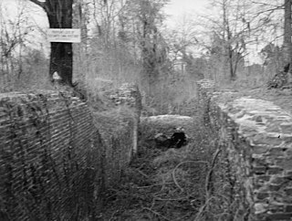
The Biggin Church Ruins are the ruins of a church in Berkeley County, South Carolina. Biggin Church is its name in the USGS Geographic Names Information System. The ruins are about 2 mi (3 km) from Moncks Corner, South Carolina, near the intersection of South Carolina Highway 402 and State Highway 8-376. The church has been burned three times since it was first constructed in about 1711. It was the church of the parish of St. John's, Berkeley The ruins are from the church built in 1761 and its reconstruction in 1781. It was included in the National Register of Historic Places on December 13, 1977. UPDATE 11/2019: Biggin Church Ruins remain part of Strawberry Chapel’s land.

The Wedge Plantation, which is also known as The Wedge or the William Lucas House, is a plantation about 5 mi (8 km) east of McClellanville in Charleston County, South Carolina. The plantation is a wedge-shaped property between the Harrietta Plantation and the Fairfield Plantation. The plantation house was built around 1830. It is located off US Highway 17 near the Santee River. It was named to the National Register of Historic Places on September 18, 1975.
The Oakland Plantation House which is also known as Youghall or Youghal Plantation House, was built about 1750 in Charleston County, South Carolina about 7 mi (11 km) east of Mount Pleasant. It is located about 1 mile (1.6 km) south of U.S. Route 17 on Stratton Place. It was named to the National Register of Historic Places on July 13, 1977.

Loch Dhu is a house in northwestern Berkeley County, South Carolina about 7 mi (11 km) east of Eutawville, South Carolina. It was built around 1812–1816. It is located close to Lake Marion about 1.3 miles (2.1 km) north of South Carolina Route 6 on Loch Dhu Lane. It was named to the National Register of Historic Places on July 13, 1977.

Brookland Plantation is a large plantation along Shingle Creek on Edisto Island, South Carolina.

Marshlands Plantation House, in Charleston, South Carolina, is an historic plantation house that was built in 1810 and listed in the National Register of Historic Places on March 30, 1973. It is a 2+1⁄2-story Federal-style plantation home. The house was relocated in the 1960s from its original location on the site of the United States Navy Shipyard. The Navy had announced it would have to demolish the empty house if it could not be relocated with the $15,000 the Navy had set aside for the purpose. The City of Charleston took temporary possession of the house, transferring it to the College of Charleston which relocated it for preservation to James Island.

Prospect Hill is an historic plantation house on Edisto Island, South Carolina. The two-story Federal house is significant for its architecture and ties to the production of sea island cotton. Constructed about 1800 for Ephraim Baynard, it sits on a bluff overlooking the South Edisto River. In 1860, William Grimball Baynard owned Prospect Hill. Baynard was an elder in the Edisto Island Presbyterian Church, a Justice of the Peace, a Justice of the Quorum, and the owner of 220 slaves. When Baynard died in 1861, his son William G. Baynard acquired the house. The house was listed in the National Register of Historic Places on 28 November 1986.

Ashley Hall Plantation is a historic plantation complex located on the Ashley River near West Ashley, Charleston County, South Carolina. The plantation was established in the early 1670s by Stephen Bull. The property includes a small tabby-walled house with a 20th-century second story addition, the ruins of the Georgian plantation house (1704) which was burned in 1865 to prevent its destruction by Union forces, a monument to the second Governor William Bull, two prehistoric Indian archaeological sites, and two 18th century well sites associated with the plantation. The tabby house is considered one of the oldest standing houses in the state.

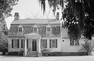
Gippy Plantation is a historic plantation house located at 366 Avenue of Oaks, near Moncks Corner in Berkeley County, South Carolina. The main house is a 2+1⁄2-story Greek Revival frame structure, with a four-column gabled pediment at the center of its main facade. The house was built by John Sims White, and was at the center of a plantation that was more than 1,800 acres (730 ha) in size. It received restoration and Colonial Revival features in the 1920s.


