
Hornell is a city in Steuben County, New York, United States. The population was 8,259 at the 2020 census. The city is named after the Hornell family, early settlers.
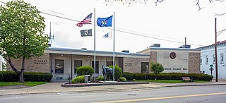
Horseheads is a village in Chemung County, New York, United States. The population was 6,606 at the 2020 census. The name is derived from the number of bleached skulls of pack horses left behind by the Sullivan Expedition.

New York State Route 17 (NY 17) is a major state highway that extends for 397 miles (638.91 km) through the Southern Tier and Downstate regions of New York in the United States. It begins at the Pennsylvania state line in Mina and runs east to Woodbury, where it turns south to run to Interstate 287 at the New Jersey state line near Suffern, where it connects to New Jersey Route 17. From the Pennsylvania border to Vestal and from Kirkwood to Windsor, NY 17 is concurrent with Interstate 86 (I-86). Eventually, the entire east–west portion of NY 17 from the Pennsylvania border to Woodbury will become I-86 as projects to upgrade the route to Interstate Highway standards are completed.

The Southern Tier is a geographic subregion of the broader Upstate region of New York State, geographically situated along or very near the state border with Pennsylvania. Definitions of the region vary widely, but generally encompass counties surrounding the Binghamton and Elmira-Corning metropolitan areas. This region is adjacent to the Northern Tier of Pennsylvania, and both these regions together are known as the Twin Tiers.
New York State Route 32 (NY 32) is a north–south state highway that extends for 176.73 miles (284.42 km) through the Hudson Valley and Capital District regions of the U.S. state of New York. It is a two-lane surface road for nearly its entire length, with few divided sections. From Harriman to Albany, it is closely parallel to Interstate 87 (I-87) and U.S. Route 9W (US 9W), overlapping with the latter in several places.

Interstate 86 (I-86) is an Interstate Highway that extends for 254.02 miles (408.81 km) through northwestern Pennsylvania and the Southern Tier region of New York, in the United States. The highway has two segments: the longer of the two begins at an interchange with I-90 east of Erie, Pennsylvania, and ends at New York State Route 26 in Vestal, New York in Broome County, while the second extends from I-81 east of Binghamton to NY 79 in Windsor. When projects to upgrade the existing NY 17 to Interstate Highway standards are completed, I-86 will extend from I-90 near Erie to the New York State Thruway (I-87) in Woodbury. The portion in Erie County, Pennsylvania, is known as the Hopkins-Bowser Highway and is signed as such at each end. In New York, the current and future alignment of I-86 is known as the Southern Tier Expressway west of I-81 in Binghamton and the Quickway east of I-81.

New York State Route 14 (NY 14) is a state highway located in western New York in the United States. Along with NY 19, it is one of two routes to transect the state in a north–south fashion between the Pennsylvania border and Lake Ontario. The southern terminus is at the state line in the Chemung County town of Ashland, where it continues south as Pennsylvania Route 14 (PA 14). Its northern terminus is at a cul-de-sac on Greig Street in the Wayne County village of Sodus Point. NY 14 has direct connections with every major east–west highway in western New York, including Interstate 86 (I-86) and NY 17, U.S. Route 20 (US 20) and NY 5, and the New York State Thruway (I-90). It passes through two cities—Elmira and Geneva—and serves many villages as it traverses the state.

New York State Route 13 (NY 13) is a state highway that runs mainly north–south for 152.30 miles (245.10 km) between NY 14 in Horseheads and NY 3 west of Pulaski in Central New York in the United States. In between, NY 13 intersects with Interstate 81 (I-81) in Cortland and Pulaski and meets the New York State Thruway (I-90) in Canastota. NY 13 is co-signed with several routes along its routing, most notably NY 34 and NY 96 between Newfield and Ithaca; NY 80 between DeRuyter and Cazenovia; and NY 5 between Chittenango and Canastota.

New York State Route 352 (NY 352) is a state highway in the Southern Tier of New York in the United States. It generally parallels the Southern Tier Expressway from the village of Riverside (exit 45) east through the city of Corning to the city of Elmira (exit 56). The portion of NY 352 west of the hamlet of Big Flats was once part of NY 17; the rest was originally New York State Route 17E. Construction of and improvements to the Southern Tier Expressway have resulted in extensions of NY 352, primarily along the former NY 17 right-of-way.
New York State Route 17M (NY 17M) is an east–west state highway in Orange County, New York, in the United States. It extends for 26.63 miles (42.86 km) from west of the city of Middletown to what is currently the north–south section of NY 17 just southeast of the village of Harriman. It is a busy main street in Middletown and the village of Monroe; in the former, it divides into a parkway for several blocks and forms the city's major commercial strip, located between the downtown district and an interchange with Interstate 84 (I-84). The rest of the road is a two-lane rural route. Between New Hampton and Goshen, the highway overlaps with U.S. Route 6 (US 6). The easternmost section of that overlap near Goshen is routed on the Quickway, making a three-route concurrency with NY 17.

Area code 607 is a telephone area code in the North American Numbering Plan for the U.S. state of New York. It serves parts of its Southern Tier. It was created in 1954 by combining the southern portion of 315 and the eastern portion of 716. Initially, in the late 1940s, area codes with a middle digit of "0" (x0x-xxx-xxxx) were assigned only to jurisdictions covering an entire state. Along with 507 in Minnesota and 606 in Kentucky, 607 was among the first such area codes to be added to a jurisdiction.

New York State Route 36 (NY 36) is a north–south state highway in the western part of New York in the United States. The highway extends for 95 miles (153 km) from the Pennsylvania state line at Troupsburg, Steuben County northward to Ogden, Monroe County, where it ends at an intersection with NY 31. Along the way, NY 36 passes through the villages of Canisteo, Dansville, Mount Morris, Caledonia, and Churchville and the city of Hornell. The section of the route between Dansville and Mount Morris closely parallels Interstate 390 (I-390); however, from Dansville south and Mount Morris north, NY 36 serves as a regionally important highway, connecting to I-86, U.S. Route 20A (US 20A), US 20, and I-490 as it heads north. At its south end, NY 36 connects to Pennsylvania Route 249 (PA 249).
New York State Route 70 (NY 70) is a short state highway in the western portion of New York in the United States. It travels through three different counties in just 18.01 miles (28.98 km) and is the primary road to and from the village of Canaseraga. The western terminus of the route is at an intersection with NY 436 in the Livingston County town of Portage. Its eastern terminus is at a junction with NY 36 in the Steuben County town of Dansville. Although NY 70 is mostly signed north–south, it follows a more southeast–northwest alignment and is considered an east–west route by the New York State Department of Transportation (NYSDOT). The portion of the route between Dalton and Canaseraga parallels both Canaseraga Creek and the Norfolk Southern Railway's Southern Tier Line.
New York State Route 417 (NY 417) is an east–west state highway located in the Southern Tier of New York in the United States. It begins at exit 20 of the Southern Tier Expressway in the city of Salamanca and ends at a junction with NY 415 in Painted Post, west of the city of Corning. At 105.25 miles (169.38 km) in length, NY 417 is the longest of the state highways that were formerly part of NY 17 before the construction of the Southern Tier Expressway. It also diverges the most from the current NY 17, coming within 100 feet (30 m) of the Pennsylvania state line at one intersection.

New York State Route 434 (NY 434) is a state highway located in the Southern Tier of New York in the United States. The route extends for 20.89 miles (33.62 km) from an intersection with NY 96 in the village of Owego to an intersection with U.S. Route 11 (US 11) in the city of Binghamton. In between, NY 434 passes through the towns of Owego and Vestal. The portion of NY 434 from the Tioga–Broome county line to downtown Binghamton is known as the Vestal Parkway.

New York State Route 17C (NY 17C) is a state highway in the Southern Tier of New York in the United States. Its western terminus is at an intersection with NY 34 in Waverly, Tioga County while its eastern terminus is at an intersection with U.S. Route 11 (US 11) in Binghamton, Broome County. The route runs concurrently with NY 96 for a block in Owego and for a few blocks with NY 26 in Endicott.

New York State Route 328 (NY 328) is a northeast–southwest state highway located entirely within the town of Southport in Chemung County, New York, in the United States. The northeast end of NY 328 is at an intersection with NY 14 in the community of Southport, and the southwest terminus is at the Pennsylvania state line, where NY 328 continues on as Pennsylvania Route 328 (PA 328). NY 328 parallels Seeley Creek, a tributary of the Chemung River, for its entire length. The entirety of the 6.15-mile (9.90 km) route is part of Corridor U of the Appalachian Development Highway System.

New York State Route 282 (NY 282) is a north–south state highway located within Tioga County in the Southern Tier of New York in the United States. It extends for 3.48 miles (5.60 km) from the Pennsylvania state line in the town of Nichols, where it connects to Pennsylvania Route 187 (PA 187), to an intersection with NY 17C in the town of Tioga. The route meets Interstate 86 (I-86) and crosses over the Susquehanna River just west of the village of Nichols.

First Transit operates several bus systems in the Southern Tier region of New York under contract. Many of these systems are medium-sized bus systems, operating within certain city, village, or county borders. With the exception of CTran Elmira, all systems operate Monday through Saturday
The Hornell Traction Company was an electric streetcar company serving Hornell and Canisteo, New York, between 1892 and 1926.


