Lio Matoh | |
|---|---|
 Lio Matoh | |
| Coordinates: 3°10′00″N115°14′00″E / 3.16667°N 115.23333°E Coordinates: 3°10′00″N115°14′00″E / 3.16667°N 115.23333°E | |
| Country | |
| State | |
| Administrative Division | Marudi |
| Elevation | 1,802 m (5,912 ft) |
Lio Matoh (also known as Lio Matu) is a remote Kenyah Badeng longhouse settlement in the mountainous interior of the Marudi division of Sarawak, Malaysia, [1] not far from the border with Indonesia. [2] It lies approximately 572.6 kilometres (356 mi) east-north-east of the state capital Kuching.
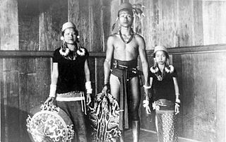
The Kenyah people are an indigenous, Austronesian-speaking people of Borneo, living in the remote Baram, Data Kakus, Data Surau, Senap River, Long Dungan, Long Busang, Long Beyak, Bintulu, Miri, Asap River resettlement for Bakun Dam, Long Bulan, Long Jawe and Belaga regions in Sarawak, Malaysia and the remote Apau Kayan, Bahau (Bau), Benua Lama, Benua Baru and Mahakam regions in East Kalimantan, Indonesia.
Marudi is a town on the Baram River in Miri Division, Sarawak, Malaysia. Marudi is a quiet town situated inland from Miri, similar in size to Kapit though nowhere near as busy. Its main attraction is another of the Brooke outposts, the beige wooden Fort Hose. It is the cultural heart of Sarawak's highland tribesfolk, collectively called Orang Ulu. Before Miri was founded, Marudi was the administrative centre of the northern region of Sarawak.
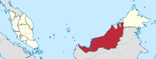
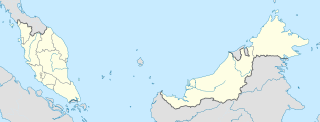
Sarawak is a state of Malaysia. The largest among the 13 states, with an area almost equal to that of Peninsular Malaysia, Sarawak is located in northwest Borneo Island, and is bordered by the Malaysian state of Sabah to the northeast, Kalimantan to the south, and Brunei in the north. The capital city, Kuching, is the largest city in Sarawak, the economic centre of the state, and the seat of the Sarawak state government. Other cities and towns in Sarawak include Miri, Sibu, and Bintulu. As of the 2015 census, the population of Sarawak was 2,636,000. Sarawak has an equatorial climate with tropical rainforests and abundant animal and plant species. It has several prominent cave systems at Gunung Mulu National Park. Rajang River is the longest river in Malaysia; Bakun Dam, one of the largest dams in Southeast Asia, is located on one of its tributaries, the Balui River. Mount Murud is the highest point in Sarawak.
Travel to Lio Matoh involves a four-hour 4WD drive from Long San, or it is possible to trek between Lio Matoh and Bario, [3] but it takes seven to nine days. [4] The Baram River begins as a stream near Bario, and it flows through Lio Matoh, the highest that small boats can navigate. [5] It is possible to travel downriver from Lio Matoh by longboat: it takes two days to get to Long San by this method. [6]

Long San is a Kenyah settlement in the Marudi division of Sarawak, Malaysia. It lies approximately 530.4 kilometres (330 mi) east-north-east of the state capital Kuching.

Bario is a community of 13 to 16 villages located on the Kelabit Highlands in Miri Division, Sarawak, Malaysia, lying at an altitude of 1000 m (3280 ft) above sea level. It is located close to the Sarawak-Kalimantan border, 178 km to the east of Miri. It is the main settlement for the indigenous Kelabit tribe. There are regular flights between the Bario, Miri and Marudi.

The Baram River is a river in Sarawak on the island of Borneo. The river originates in the Kelabit Highlands, a watershed demarcated by the Iran Mountains of East Kalimantan, which form a natural border with Sarawak. The river flows westwards through tropical rainforest to the South China Sea. The Baram River terminates in a delta, which is subdivided into two units: East Barma Delta of Middle-Late Miocene age and West Baram Delta of Late Miocene-Quaternary age. The western unit is composed of mudstones enriched in organic components which constitute substantial oil and gas reserves.
Neighbouring settlements include:
- Long Metapa 7.6 kilometres (4.7 mi) east
- Long Tungan 8.3 kilometres (5.2 mi) southwest
- Long Sait 16.2 kilometres (10.1 mi) north
- Long Banga 17.1 kilometres (10.6 mi) east
- Long Selaan 19.1 kilometres (11.9 mi) southwest
- Long Moh 21.6 kilometres (13.4 mi) southwest
- Long Peluan 22.1 kilometres (13.7 mi) northeast
- Long Baleh 25.1 kilometres (15.6 mi) northeast
- Long Datih 32.4 kilometres (20.1 mi) north
- Lepu Wei 32.8 kilometres (20.4 mi) northeast
- Long Pasia in Sabah.
- Long Mio in Sabah.
Long Metapa is a settlement in Sarawak, Malaysia. It lies approximately 580.2 kilometres (361 mi) east-north-east of the state capital Kuching.
Long Tungan is a settlement in the Marudi division of Sarawak, Malaysia. It lies approximately 564.4 kilometres (351 mi) east-north-east of the state capital Kuching.
Long Banga is a rural village located in the north east of Sarawak, Malaysia, in the Marudi division. It lies approximately 589.6 kilometres (366 mi) east-north-east of the state capital Kuching. The name of "Long Banga" originated from a small river near the site of the village.
