Long Selaan | |
|---|---|
 Long Selaan | |
| Coordinates: 3°05′00″N115°05′00″E / 3.08333°N 115.08333°E Coordinates: 3°05′00″N115°05′00″E / 3.08333°N 115.08333°E | |
| Country | |
| State | |
| Elevation | 1,844 m (6,050 ft) |
Long Selaan (also written Long Sela'an) is a settlement in Sarawak, Malaysia. [1] It lies approximately 553.9 kilometres (344 mi) east-north-east of the state capital Kuching.
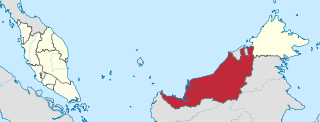
Sarawak is a state of Malaysia. The largest among the 13 states, with an area almost equal to that of Peninsular Malaysia, Sarawak is located in northwest Borneo Island, and is bordered by the Malaysian state of Sabah to the northeast, Kalimantan to the south, and Brunei in the north. The capital city, Kuching, is the largest city in Sarawak, the economic centre of the state, and the seat of the Sarawak state government. Other cities and towns in Sarawak include Miri, Sibu, and Bintulu. As of the 2015 census, the population of Sarawak was 2,636,000. Sarawak has an equatorial climate with tropical rainforests and abundant animal and plant species. It has several prominent cave systems at Gunung Mulu National Park. Rajang River is the longest river in Malaysia; Bakun Dam, one of the largest dams in Southeast Asia, is located on one of its tributaries, the Balui River. Mount Murud is the highest point in Sarawak.
Malaysia is a country in Southeast Asia. The federal constitutional monarchy consists of 13 states and three federal territories, separated by the South China Sea into two similarly sized regions, Peninsular Malaysia and East Malaysia. Peninsular Malaysia shares a land and maritime border with Thailand and maritime borders with Singapore, Vietnam, and Indonesia. East Malaysia shares land and maritime borders with Brunei and Indonesia and a maritime border with the Philippines and Vietnam. Kuala Lumpur is the national capital and largest city while Putrajaya is the seat of federal government. With a population of over 30 million, Malaysia is the world's 44th most populous country. The southernmost point of continental Eurasia, Tanjung Piai, is in Malaysia. In the tropics, Malaysia is one of 17 megadiverse countries, with large numbers of endemic species.

Kuching, officially the City of Kuching, is the capital and the most populous city in the state of Sarawak in Malaysia. It is also the capital of Kuching Division. The city is situated on the Sarawak River at the southwest tip of the state of Sarawak on the island of Borneo and covers an area of 431 square kilometres (166 sq mi) with a population about 165,642 in the Kuching North administrative region and 159,490 in the Kuching South administrative region—a total of 325,132 people.
The village is located in the Ulu Baram area on the Baram River between Long Semiyang (upstream) and Long Moh (downstream). [2] Kenyah villages are often located where a small stream joins a large river, and take the name of the stream; [3] in this case the small stream is Sungai Sela'an. [2]
Ulu Baram is a remote area of Sarawak in Malaysia. It is an encased alluvial plain, created in part by the Baram River.

The Baram River is a river in Sarawak on the island of Borneo. The river originates in the Kelabit Highlands, a watershed demarcated by the Iran Mountains of East Kalimantan, which form a natural border with Sarawak. The river flows westwards through tropical rainforest to the South China Sea. The Baram River terminates in a delta, which is subdivided into two units: East Barma Delta of Middle-Late Miocene age and West Baram Delta of Late Miocene-Quaternary age. The western unit is composed of mudstones enriched in organic components which constitute substantial oil and gas reserves.

Long Moh is a longhouse settlement in the Marudi division of Sarawak, Malaysia. It lies approximately 551.6 kilometres (343 mi) east-north-east of the state capital Kuching.
There are three subgroups of the Kenyah people in the village: Lepo'Ke, Lepo'Belukun and Lepo'Tepuan. [4] There has been a longhouse on this site for at least fifty years. [5] When Lepo'Tau people moved to the area from the Silat River, the people of Long Sela'an gave an area of land downriver to them, which became the settlement of Long Moh. [3]
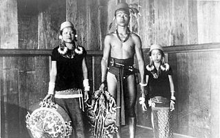
The Kenyah people are an indigenous, Austronesian-speaking people of Borneo, living in the remote Baram, Data Kakus, Data Surau, Senap River, Long Dungan, Long Busang, Long Beyak, Bintulu, Miri, Asap River resettlement for Bakun Dam, Long Bulan, Long Jawe and Belaga regions in Sarawak, Malaysia and the remote Apau Kayan, Bahau (Bau), Benua Lama, Benua Baru and Mahakam regions in East Kalimantan, Indonesia.
Neighbouring settlements include:
- Long Moh 2.6 kilometres (1.6 mi) southwest
- Long Tungan 10.8 kilometres (6.7 mi) northeast
- Long Taan 18.5 kilometres (11.5 mi) southwest
- Lio Matoh 19.1 kilometres (11.9 mi) northeast
- Long Metapa 26.5 kilometres (16.5 mi) northeast
- Lio Lesong 26.5 kilometres (16.5 mi) southwest
- Long Salt 27.1 kilometres (16.8 mi) northeast
- Long Palai 28 kilometres (17.4 mi) west
- Long Anap 29.7 kilometres (18.5 mi) west
- Long Apu 30.2 kilometres (18.8 mi) west
- Long Pasia in Sabah
- Long Mio in sabah
Long Tungan is a settlement in the Marudi division of Sarawak, Malaysia. It lies approximately 564.4 kilometres (351 mi) east-north-east of the state capital Kuching.
Long Taan is a longhouse settlement in the Marudi division of Sarawak, Malaysia. It lies approximately 536.5 kilometres (333 mi) east-north-east of the state capital Kuching.
Lio Matoh is a remote Kenyah Badeng longhouse settlement in the mountainous interior of the Marudi division of Sarawak, Malaysia, not far from the border with Indonesia. It lies approximately 572.6 kilometres (356 mi) east-north-east of the state capital Kuching.