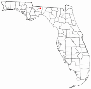
Bradford County is a county in the U.S. state of Florida. As of the 2010 census, the population was 28,520. Its county seat is Starke. Bradford County is the home of the Florida State Prison as well as several other state correctional facilities. It is named after Richard H Bradford, a Confederate Captain who fought during the American Civil War.

Starke is a city in and the county seat of Bradford County, Florida, United States. The population was 5,796 at the 2020 census.

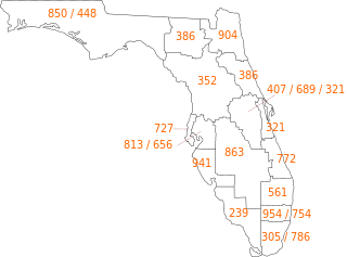
Area code 352 is a NANPA telephone dialing area around Ocala, Florida. It was split from area code 904 in 1996.
State Road 21 (SR 21) runs mostly in a southwest-to-northeast direction in the US state of Florida from McMeekin to Jacksonville. It is also known as Blanding Boulevard for much of its length.

Melrose is an unincorporated community in Alachua, Bradford, Clay, and Putnam counties in the U.S. state of Florida. It lies on State Road 26, approximately 17 mi (27 km) east of Gainesville and approximately 50 mi (80 km) southwest of Jacksonville. The town lies on Lake Santa Fe and the Santa Fe River.
State Road 16 (SR 16) runs from northwest to southeast between Raiford and St. Augustine. It passes through the towns of Starke and Green Cove Springs in addition to providing access to Camp Blanding. Major roads and/or highways that SR 16 crosses include: US 301, SR 21, US 17, SR 13, Interstate 95 and US 1.
State Road 100 is a 153-mile-long (246 km) east–west highway serving northeastern Florida. Its western terminus is at the Georgia-Florida border four miles (6.4 km) north of Avoca, Florida ; its eastern terminus is an intersection with Shore Scenic Highway in Flagler Beach. The portion west of Lake City is only signed as portions of US 41 and US 129, both of which run north–south.
State Road 200 is a major diagonal road in central and northeastern Florida. Its southern terminus is at US 41 in Hernando. Its northern terminus is at SR A1A in Fernandina Beach, at the corner of Atlantic Avenue and Fletcher Avenue.
State Road 371 (SR 371) runs through Tallahassee as a primarily east west route. In 2018, the Florida Legislature designated the Orange Avenue section of the roadway as C.K. Steele Memorial Highway.

Bradfordville is an unincorporated community in northern Leon County, Florida, United States. It is 8 miles (13 km) north of Tallahassee and south of the Florida/Georgia state line by 8 miles (13 km) at the intersection of US 319 and County Road 0342. Elevation is 237 feet.
King's Highway 88, commonly referred to as Highway 88, was a provincially-maintained highway in the Canadian province of Ontario, located in what is now the town of Bradford West Gwillimbury, that connected former Highway 27, in the village of Bond Head, with former Highway 11 in the town of Bradford. The short 9.7-kilometre (6.0 mi) route was established in 1938, though the road it followed had existed for over a century at that time.
U.S. Highway 1 (US 1) in Florida runs 545 miles (877 km) along the state's east coast– from Key West to its crossing of the St. Marys River into Georgia north of Boulogne –and south of Folkston. US 1 was designated through Florida when the United States Numbered Highway System was established in 1926. The road is maintained by the Florida Department of Transportation (FDOT).

The Santa Fe River is a 75-mile (121 km) river in northern Florida. The watershed of the river is approximately 1,380 square miles (3,574 km2) and spreads across southern Columbia, southern Suwannee, western Bradford, far southern Baker, Union, northern and eastern Gilchrist, and northern Alachua counties. The headwaters of the river are Lake Santa Fe, near Keystone Heights. The Santa Fe River is usually a slow-flowing river. This slow speed, combined with the abundant leaf-drop from nearby trees, especially Bald Cypress, leads to a very dark-brown river due to dissolved tannins.

Keystone Airpark, also known as Keystone Heights Airport, is a public use airport located 9 miles south of the Starke in Bradford County, Florida, United States. The airport is situated in Bradford County and Clay County

New River is a 31-mile-long (50 km) tributary of the Santa Fe River in northern Florida, United States. The river was used as the border to create Union County from Bradford County in 1921.

This is a list of the National Register of Historic Places listings in Bradford County, Florida.
State Road 230 is a short state highway in northeastern Florida that runs between Starke, Florida and Camp Blanding. It runs east and west and is always no more than two lanes wide. Within the Starke city limits, and slightly beyond, the road is known as Call Street.

State Road 235 is a south–north state highway in Alachua County, Florida. It runs from U.S. Route 441 in Alachua to Brooker, and has county-maintained segments in Alachua and Bradford Counties, which were once part of SR 235.
State Road 231, locally known as Dr. Martin Luther King Jr. Avenue and SW 6th Avenue, is a north-south discontinuous route running through Union County, Bradford County, and Alachua County, Florida.


