County Route51 is a major road running southwest-to-northeast from CR80 to NY24 and CR94 in Riverside.
Route description
The road begins at CR80 (Montauk Highway) just east of the eastern terminus of CR98 (Frowein Road). The route runs along the west side of two local airports (Lufker Airport and Spadaro Airport) where it also crosses the former right-of-way for the Manorville Branch of the Long Island Rail Road. At NY27 (Sunrise Highway), CR51 becomes a four-lane expressway and is one of the roads served by the incomplete exit61. The other one is CR55, which served as part of NY27 until Sunrise Highway was extended east of the interchange. CR51 became the northern terminus of CR55 in the 1980s.
The road continues northeast through the hills of the Long Island Pine Barrens. Soon thereafter, CR51 reaches the intersection of Speonk–Riverhead Road (former CR88), which leads to the Suffolk County Community College eastern campus. Northeast of that point, the road literally starts to go downhill.
At Wildwood Lake, there is an incomplete at-grade interchange with CR63 (Lake Avenue), which used to be part of East Moriches–Riverhead Road. From there, the road runs north through Cranberry Bog County Park. It curves northeast again at a plot of land that was originally intended to be the southern terminus of CR103 (Cedar Swamp Road), then enters a series of Suffolk County Government buildings, where it finally terminates at an at-grade intersection at NY24 and CR94 in Riverside.
County Route52 is a short two-lane road called Sandy Hollow Road and is a divided highway with at least one turning ramp only at both ends. The road serves as a connecting route between NY27/CR39 and CR38.
County Route53 was Clinton Avenue in Bay Shore. Today it serves as a southbound only suffixed route of CR13, known as CR13A south from the intersection of Reil Place. North of this intersection, Clinton Avenue is a string of roads running parallel to Fifth Avenue maintained by the town of Islip.
County Route54 is mainly Hulse Landing Road, a two-lane road that runs north and south Wading River.
The northern terminus of CR 54 at the wye at Wildwood State Park.
The route begins at Sound Avenue in Wading River, with Hulse Landing Road continuing south from the intersection. The road passes by a Wading River Fire Department depot and several businesses within the housing it passes through.
Though Hulse Landing Road heads straight north toward Old North Country Road along the western border of Wildwood State Park, CR54 curves northeast into Wildwood Road, the southern entrance of the park.
Although there was signage at the southern terminus of Hulse Landing road at NY 25A, the portion of CR 54 between Sound Avenue and 25A has been decommissioned.
The road formerly began at NY25A near land formerly owned by the Calverton Naval Weapons Industrial Reserve Plant. Between NY25A and Sound Avenue the formerly proposed Nugent Drive Extension was supposed to cross over CR54 at an interchange. The Nugent Drive Extension was intended to serve as the relocated NY25A. Sound Avenue was to be transformed into a dead end street west of former CR54. Today, the land intended to be used for the road is now part of a housing development.
The portion of CR54 north of Sound Avenue was designated as NY352 from c.1931[4][5] to c.1938.[6][7]
As the name implies, the road originally went from Manorville to Eastport, and was acquired by the Suffolk County Department of Public Works in 1935. The section between Montauk Highway and CR71 (Old Country Road) was once part of Montauk Highway itself. When Sunrise Highway terminated at exit61, NY27 took a right turn along a temporary concurrency with CR55 until it reached Montauk Highway, and continued eastward toward Montauk.[10]
Construction of the vast and complex exit61 interchange forced the realignment of CR55, as well as Head of the Neck Road.[11] When CR111 was built between the Long Island Expressway and Sunrise Highway during the 1970s, it replaced Eastport–Manorville Road north of the road's current terminus towards the L.I.E. However, Suffolk County Planning Department wanted to build a new extension of CR55 north of CR111 leading to the Grumman Calverton Airport. An interchange with the expressway was also supposed to have been built.[12] Neither of these proposals were ever accepted.
CR55 was truncated to East Moriches–Riverhead Road in 1986, and the rest of Eastport–Manor Road fell under the jurisdiction of the Town of Brookhaven. This section is the home to the Shrine of Our Lady of The Island.
County Route56 is a bi-directional frontage road along NY27 known as Victory Avenue. It stretches from CR16 between Sunrise Highway and CR21 and ends at William Floyd Parkway, however Victory Avenue extends east of the CR56 designation. At one time, it also included Horseblock Road east of Waverly Avenue in Farmingville.
The beginning of CR 56 east of CR 16 at the interchange with NY 27.
CR56 provides the entrance to Southaven County Park along Carmans River, and the median of Sunrise Highway near this section contains a pine tree lined median in front of those entrances. The setting along these roads is similar to the one on the Southern State Parkway west of Belmont Lake State Park. After the intersection of River Road, a westbound on-ramp to Sunrise Highway, which was originally built with two different access points.
East of the William Floyd Parkway interchange, Victory Boulevard remains a two-lane bi-directional frontage road for Sunrise Highway, but this section is a Town of Brookhaven maintained road. It skirts along the south end of the runway for Brookhaven Airport west of Winters Drive, and goes as far east as Barnes Road in Moriches.
County Route57 runs mostly east and west from NY231 in Deer Park to NY27A in downtown Bay Shore. It includes Bay Shore Road, Howell's Road, and Third Avenue.
Route description
No sooner does CR57 start at NY231 in a sharp southeasterly direction, does it encounter Carll's Path and CR4 (Commack Road). The intersection of Weeks Road is where the road crosses the Babylon–Islip Town Line, the southeastern angle of the road levels off, and was where the Babylon–Northport Expressway was intended to cross over, with a possible interchange. CR82's northern terminus is at CR57, however Udall's Road continues north of this terminus as a town of Islip Street. Howell's Road is cut off by the interchange with the Southern State Parkway. Originally it crossed Bay Shore Road, then moved along the south side and intersected with Bay Shore Road again along with Muncey Road. Besides serving exit41 on the Southern State, it also contains on and off-ramps from the ramp between Robert Moses Causeway and Heckscher State Parkway.
At the intersection of Muncey Road, CR57 moves from Bay Shore Road to Howell's Road. From there it becomes the northern border of the village of Brightwaters. Eastbound and westbound carriageways are separated by two different underpasses beneath the interchange with NY27 (Sunrise Highway), both of which briefly join the service roads. When the eastbound and westbound lanes merge again, the first site the encounter is The John Thomas Inne on the southeast corner of Howell's Road and the eastbound service road. At Manatuck Boulevard, the Brightwaters village line moves from the north side of CR57 to the south side, but still runs along the road until Clinton Avenue, where CR57 leaves Brightwaters just west of the intersection of CR13. CR57 turns south onto Third Avenue, where it crosses CR50, and finally terminates at NY27A in downtown Bay Shore.
County Route57B was the former designation for Third Avenue north of Howell's Road to either Sunrise Highway eastbound service road, or possibly as far north as CR13 and Brook Avenue. The road was decommissioned and is now maintained by the town of Islip.
County Route58, locally known as Old Country Road, serves as a northern bypass of the section of NY25 that runs through the downtown area of Riverhead. Built through what were once relatively desolate fields, the road is now home to several large shopping centers and big box stores, and as such, has become, at least on the weekends, even more choked than the road it is supposed to bypass.[17]
Route description
The highway starts at the sprawling junction of NY25 and I-495, as a four-lane divided highway. The western split between NY25 and CR58 is entirely grade-separated with turnarounds in the median. This was built in conjunction with the interchanges with the Long Island Expressway at exits72 and73. After the incomplete interchange with I-495 (which would have been expanded when I-495 was extended eastward), the road quickly narrows to four lanes with a center-turn lane as it passes the large Tanger Outlet Center complex, which was built during the 1990s.
Continuing eastward, the road alternates between three lanes and four lanes, always with a center turn lane. The portion of the road between the outlet center and the traffic circle at CR73 has been the site of the most active retail development, spread over several decades. As such, the road's width and treatment vary because the task of widening largely fell to each individual developer of the new strip malls. Of course, the area is now very congested, particularly because the number of traffic lights on the road has increased from six in 1990 to 13 in 2007.
After the traffic circle at CR73, the road continues for the rest of its length with only two lanes plus the center-turn lane. It terminates at NY25 northeast of the town of Riverhead.
County Route60 is a county road formerly known as CR38A. It is a pair of two-lane roads (Noyack–Long Beach Road and Short Beach Road) that run along the peninsula connecting Noyack with North Haven.
Noyack–Long Beach Road was previously known as Long and Short Beach Highway. CR60 begins at an at-grade interchange with CR38 in Noyack between Noyac Bay and Payne's Creek. It narrows down to a two-lane undivided highway which runs on a peninsula, with a parallel park access road on the north side and a bicycle lane on the south side. The western interchange indicates a potential proposal to widen the road to a possible four-lane divided highway that was never built.
The peninsula ends in North Haven, where Noyack–Long Beach Road becomes Short Beach Road at Third Street. CR60 ends at a traffic circle at NY114 and Tyndall Road, although NY114 continues in the same direction as Short Beach Road until it curves to the north and reaches the South Ferry Port to Shelter Island.
County Route61 is unsigned Waverly Avenue, a mainly two-lane road that runs north and south along the Islip–Brookhaven town line until the town line makes a sharp left along the Greenport Branch of the Long Island Rail Road.
Route description
CR61 begins at CR19, in the town of Brookhaven where that section of Waverly Avenue becomes Patchogue–Holbrook Road, and Log Road becomes a dead end street. From here, road takes a northeasterly turn and straightens out along the Islip–Brookhaven town line. CR61 is the last interchange along Woodside Avenue (CR99) before its western terminus at Patchogue–Holbrook Road. Access is only available from Woodside Avenue; however this interchange also includes an underpass for a driveway to the Holtsville I.R.S. office. Further north, motorists will encounter the southern terminus of Blue Point Road, which until the town of Islip allowed development on the west side of the road in the mid-20th century, actually reached Blue Point.
The last intersection within range of the town of Islip is for Furrow Roads (eastern terminus of CR90) and Barretts Avenue, both of which were once intended to be integrated into the Central Suffolk Highway. Before the grade crossing of the Main Line of the Long Island Rail Road, a driveway for the former site of the Holtsville train station, can be found on the right side, while the Islip–Brookhaven town line takes a left turn to follow the tracks into Ronkonkoma, and Lakeland. After this crossing, Waverly Avenue immediately crosses Long Island Avenue, which until the mid-1970s terminated at Waverly Avenue, forcing westbound motorists to make a right turn and then a left onto Union Avenue across from the Holtsville Fire Department.
Waverly Avenue crosses over the Long Island Expressway with no access other than to the service roads. However, until CR97 (Nicolls Road) was extended to the Long Island Expressway, it served as one of the eastbound destinations for exit62. On the northeast corner of the westbound service road is the Waverly Avenue Elementary School. The remainder of CR61 is residential and wooded. Due to the lack of county route shields, CR61 ends unceremoniously at CR16 (Horseblock Road), east of where CR16 moves from the eastern terminus of Portion Road onto Horseblock Road. North of Horseblock Road, a town maintained extension of Waverly Avenue curves through the hills of a housing development towards College Road, at the former intersection with Highview Drive, a partial dirt road that had street name signs years after being closed off.
County Route62 can be found on the west side of the Shinnecock Canal along Newtown Road north of Montauk Highway and partially into Sunset Avenue at the Shinnecock County Marina. The entire route is in the hamlet of Hampton Bays.
Route description
CR62 begins as Newtown Road at a divided section of Montauk Highway (CR80) and is the last intersection on the highway before it crosses the Shinnecock Canal. Access to CR62 is available from both directions on Montauk Highway, but traffic entering it can only do so from a south to westbound ramp that may have been a former segment of Montauk Highway itself. A U-turn ramp exists for north to westbound traffic. The road then passes by some town of Southampton parkland, and then an 11-foot-7-inch (3.53m) bridge beneath the Montauk Branch of the Long Island Rail Road. Further north, a local street named Gate Street leads to the only street that runs closer to the canal than Newtown Road does.
Like CR39B on the east side of the canal, CR62 runs beneath the Sunrise Highway Bridge over the canal, but has no access to that road. After passing by some marinas and shore front homes, CR62 seems to terminate at a T-intersection, but in reality makes a right turn at that intersection onto Sunset Avenue. Newtown Road, on the other hand, continues northwest through part of the Shinnecock Indian Reservation along the coast of the Great Peconic Bay and then west along the south end of Squire Pond before the intersection of Squiretown Road which leads to CR32 and the Ponquogue Bridge, and Red Creek Road, which runs along the bay again towards NY24.
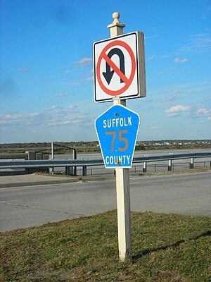
County Route63 is a two-lane north–south highway that connects Riverside and NY 24 with Riverhead and NY 25. It is named Lake Avenue (formerly Old East Moriches–Riverhead Road) south of a traffic circle with NY 24 and Peconic Avenue north of it. It has a posted 55mph (89km/h) speed limit for a majority of its length. The road begins at an intersection with CR51 and heads northeast, roughly continuing the track of CR51 while that road curves north onto Center Drive South. It passes the shores of Wildwood Lake and provides access to streets leading to homes along the north and east side of the lake. The road then intersects a traffic circle, which forms the gateway into downtown Riverhead. Here, it links with CR104, CR94, and NY24. The road then continues a short ways north via Peconic Avenue to terminate at an intersection with NY25. The road is a former portion of CR51, and the CR63 designation was given to this section when CR51 was shifted to the newly built Center Drive South.
County Route64 is the unsigned designation for Bellport Avenue, and Station Road from the village of Bellport to Coram–Yaphank (Mill) Road and for Coram–Yaphank Road from Bellport Avenue to NY112 since 1998. In the 1960s it was applied to Dunes Road–not to be confused with CR89 in Westhampton Beach–near Meschutt Park at the Shinnecock Canal. On October30, 1975 it was applied to Long Island Avenue (also known as Patchogue Road) between CR101 and CR21 on the north side of the Long Island Expressway in Yaphank.
County Route65 is primarily Middle Road from Sayville to Patchogue, where it includes Atlantic Avenue, Weeks Street, River Avenue, and Division Street. In the late 1990s, Middle Road was converted into a one-way street between Main Street and Foster Avenue, forcing Foster Avenue to become part of CR65.
Route description
CR65 begins as Middle Road at CR85 (Main Street), although this section is only a one-way street until it reaches the first intersection at Collins Avenue, which is across the street from the NRHP-listed Sayville Congregational Church. The next intersection is Foster Avenue, which is the only two-way access to Montauk Highway. From here Middle Road passes by St. Anne's Episcopal Church, which was recently added to the National Register of Historic Places, and contains the St. Anne's Cemetery in the back. The road then runs through the Sans Soucci Lakes County Park, with a driveway to the NRHP-listed John Ellis Roosevelt Estate on the north side. East of the parkland, the road officially enters the hamlet of Bayport. The first intersection to pass for a major intersection within Bayport is McConnell Avenue. At the intersection with the two-lane divided Edgewater Avenue, CR65 takes a northeasterly turn and serves as the southern border of Bayport Commons Park. Bayview Avenue is also across from this park, which ends just west of the intersection of Conetquot Road. Snedecore Avenue intersects Middle Road and is one of the few streets along the road to span from Montauk Highway to the Great South Bay, thus making it an important street by local standards.
One of the few areas of commercial zoning along the road is at the blinker-light intersection of Bayport Avenue, where Middle Road moves slightly to the southeast, only to return to the northeast before reaching Gillette Avenue. Shortly after this, CR65 crosses the Islip–Brookhaven town line, where it enters the hamlet of Blue Point. In what will be a common pattern in the town of Brookhaven, Middle Road makes a sharp left turn to the north, then a right turn at the intersections of Humphrey Road (to the west) and Avery Lane (to the north). CR65 then crosses a creek that's within a New York State Department of Environmental Conservation preserve area. Once the road exits this preserve, it intersects Lane's End and Nelson Avenue, where it runs between two mansions, one of which is the St. Ursula Retreat Center on the southwest corner of the intersection with Blue Point Avenue. Blue Point Avenue and Middle Road has another set of blinker-lights, partially because it is a four-way stop intersection and partially because it is actually a pair of T-intersections set close to one another that requires a slight shift to the right for all traffic on Middle Road. After this fiasco, the road passes Bergen Avenue and makes a slight curve to the northeast, only to curve east again and cross the Corey's Creek Bridge, where one can find sites such as the Blue Point Marina, Corey's Creek Park, and a local roadside luncheonette.
Middle Road ends at Atlantic Avenue and CR65 turns north onto Atlantic Avenue, until it reaches the intersection of Weeks Street, and turns back east again. From there, it crosses Tuthills Creek and enters the village of Patchogue, where it ends at River Avenue, and as Middle Road did with Atlantic Avenue, CR65 turns north onto River Avenue. Just before River Avenue reaches the at-grade crossing with the Montauk Branch of the Long Island Rail Road, CR65 turns east one last time at the intersection of Division Avenue, which runs directly along the south side of the tracks. Before crossing the Patchogue River, CR65 move slightly away from the edge of the tracks, but not far enough away to be out of sight from the tracks. CR65 ends at CR19 (West Avenue). Consequently, CR19's southern terminus is also at this intersection, but West Avenue continues south as a Patchogue Village street to Patchogue Bay. Likewise, Division Street east of CR65 is also a village maintained street that continues eastward in front of Patchogue Railroad Station which spans the north side of Division Street between West Avenue and South Ocean Avenue. The road then become Baker Street at Patchogue Village Hall and finally terminates at Rider Avenue.
County Route66 is Deer Park Road East in Dix Hills, serving as a connecting spur between NY231 (via CR35) and NY25. Until 1972, it was designated CR35B.
Route description
CR66 begins at a wye intersection with CR35, which at one time was also intended to include a North Deer Park Avenue Spur connecting to the Babylon–Northport Expressway.[10] The only other major intersection between the two termini of CR66 is a segment of DeForest Road which begins as the off-ramp of exit42N of the Northern State Parkway. All other intersections at this point are residential streets. CR66 ends at NY25 in Elwood, just west of Elwood Road, where the interchange for the former Babylon–Northport Expressway was supposed to exist.
County Route67 consists of part of Half Hollow Hills Road and all of the remaining segment of Long Island Motor Parkway that is still suitable for motor vehicles.
County Route67A was originally Half Hollow Hills Road from Pinelawn Road to Motor Parkway, that served as an extension of CR67. It was eventually decommissioned and merged into CR67.
County Route68 is an unsigned two-lane road that runs through historic Stony Brook along Main Street, Christian Avenue, and eventually into Setauket along Ridgeway Avenue, part of which was at one time part of NY25A.[29] The entire route is also shared with New York State Bicycle Route 25.[30]
Route description
CR68 begins as Main Street at NY25A near the Stony Brook Museum and Carriage House, as a north–south road. It begins at a segment of NY25A that briefly runs north and south within Stony Brook before making a sharp right turn towards Setauket, Port Jefferson and points east. A west-to-northbound ramp exists on the northeast corner of the intersection, When CR68 runs through the Stony Brook village center, it turns into an east–west road. At a fork in the road with Hollow Road which heads southeast, CR68 moves onto Christian Avenue and heads northeast. The rest of CR68 is surrounded by historic houses, although it also includes the North Shore Montessori School and a local Methodist Church and Cemetery. From there it intersects the appropriately named Blinker Light Road and Cedar Street, which are less than five feet away from each other. Cedar Street heads toward The Stony Brook School and Stony Brook's train station, while CR68 continues northeast into what is commonly referred to by mapmakers as "Old Stony Brook."
Christian Avenue continues northeast but CR68 moves southeast onto Bailey Hollow Road, which ends at the intersection of Quaker Path Road, and becomes Ridgeway Avenue. Here, it also leaves Stony Brook and enters Setauket. The next major intersection is North Country Road to the south and Main Street to the north. The former connecting north-to-eastbound ramp which was used by eastbound NY25A can still be seen on the southeast corner of North Country Road and Ridgeway Avenue.[31] CR68 then climbs a hill before ending at NY25A just north of the formerly proposed Setauket–Port Jefferson Bypass.
County Route69 is the designation for the two-lane Cartwright Road on Shelter Island. The road begins at a traffic circle on NY114; however, this designation only goes as far north as Ram Island Road.
County Route70 is Old West Lake Drive and formerly CR77A. The road runs northwest from NY27 along the southwest side of Montauk Lake before reaching CR77.
The turning ramp between CRs 71 and 55 that used to be part of Montauk Highway.
County Route71 is also Old Country Road, but strictly in Eastport and the western town of Southampton. It is a former section of Montauk Highway. The last segment to be part of Montauk Highway was in Eastport from the current west end to CR55 (Eastport–Manor Road). The right turn ramp from Old Country Road to Eastport–Manor Road is where eastbound Montauk Highway used to go.[11]
County Route72 was Atlantic Avenue in East Moriches until 1973. The road remains a north and south two-lane street that begins at West Cove near Moriches Bay then intersects with Moriches Avenue which leads to USCG Station East Moriches on Hart's Cove.[35] It terminated at NY27A (now CR80), but Atlantic Avenue continues northbound into Pine Street, the former location of East Moriches Station. Pine Street crosses CR98 (Moriches Bypass), then East Chapman Boulevard, before becoming a dead-end street at the right-of-way for the eastbound service road of NY27, only to begin again on the other side on the westbound service road, cross the former LIRR Manorville Branch right-of-way, and end at Head of the Neck Road.
County Route73 is Roanoke Avenue from downtown Riverhead north towards the farms along the Long Island Sound. Roanoke Avenue in Downtown Riverhead was originally part of CR43 between NY25 (Main Street) and Northville Turnpike. This segment was replaced in 1943, when CR73 was established on Roanoke Avenue. In 1957, CR73 was expanded to overlap CR73A, which was eliminated in 1973.
County Route74 was the unmarked Abrahams Landing Road and Bendigo Road from near NY27 at the Amagansett train station past the Devon Yacht Club north of Napeague Bay, to Cranberry Hole Road (CR33). It was intended to be reassigned to the Promised Land Road Extension, a proposed western extension of CR33 to Abrahams Landing Road terminating at CR45 (Springs–Amagansett Road) near Montauk Highway.
Montauk Highway is an east–west road extending for 95 miles (153 km) across the southern shore of Long Island in Suffolk County, New York, in the United States. It extends from the Nassau County line in Amityville, where it connects to Merrick Road, to Montauk Point State Park at the very eastern end of Long Island in Montauk. The highway is known by several designations along its routing, primarily New York State Route 27A (NY 27A) from the county line to Oakdale and NY 27 east of Southampton. The portion of Montauk Highway between Oakdale and Southampton is mostly county-maintained as County Route 80 and County Route 85.
New York State Route 25A (NY 25A) is a state highway on Long Island in New York, United States. It serves as the main east–west route for most of the North Shore of Long Island, running for 73 miles (117 km) from Interstate 495 (I-495) near the Queens–Midtown Tunnel in the New York City borough of Queens to NY 25 in Calverton, Suffolk County. The highway is a northern alternate route of NY 25, which follows a more inland routing along Jericho Turnpike.
New York State Route 25 (NY 25) is an east–west state highway in downstate New York in the United States. The route extends along the central parts and North Shore of Long Island for just over 105 miles (169 km) from east midtown Manhattan in New York City to the Cross Sound Ferry terminal at Orient Point on the end of Long Island's North Fork. NY 25 is carried from Manhattan to Queens by way of the double-decked Queensboro Bridge over the East River.
New York State Route 27 (NY 27) is a 120.58-mile (194.05 km) long state highway that runs east–west from Interstate 278 (I-278) in the New York City borough of Brooklyn to Montauk Point State Park on Long Island, New York. Its two most prominent components are Sunrise Highway and Montauk Highway, the latter of which includes the Montauk Point State Parkway. NY 27 acts as the primary east–west highway on southern Long Island east of the interchange with the Heckscher State Parkway in Islip Terrace. The entire route in Suffolk, Nassau, and Queens counties were designated by the New York State Senate as the POW/MIA Memorial Highway. The highway gives access to every town on the South Shore. NY 27 is the easternmost state route in the state of New York, as well as the longest highway on Long Island.
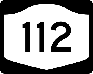
New York State Route 112 (NY 112) is a state highway located entirely within the town of Brookhaven in Suffolk County, New York, in the United States. It runs from an intersection with Montauk Highway in the village of Patchogue to a junction with NY 25A in Port Jefferson Station. It is known locally as Medford Avenue in Patchogue and Patchogue Road in Terryville and Port Jefferson Station. The official name for the road outside these areas is "Patchogue–Port Jefferson Road", though it is often signed simply as "Route 112".
New York State Route 24 (NY 24) is a 30.84-mile-long (49.63 km) east–west state highway on Long Island in the U.S. state of New York. The highway is split into two segments, with the longer and westernmost of the two extending 18.68 miles (30.06 km) from an interchange with Interstate 295 and NY 25 in the Queens Village section of the New York City borough of Queens to an intersection with NY 110 in East Farmingdale in the Suffolk County town of Babylon. The shorter eastern section, located in eastern Suffolk County, extends 12.16 miles (19.57 km) from an interchange with I-495 in Calverton to an intersection with County Route 80 (CR 80) in Hampton Bays.
New York State Route 111 (NY 111) is a state highway located in Suffolk County, New York, in the United States. It runs north–south for 9.42 miles (15.16 km) through the towns of Islip and Smithtown, connecting NY 27A in the town seat of Islip to the east end of the NY 25 and NY 25A concurrency in Smithtown's Village of the Branch. Most of the road is a two-lane highway, save for several short four-lane stretches in the vicinity of interchanges along the route. NY 111 was assigned as part of the 1930 renumbering of state highways in New York as an East Islip–Village of the Branch highway, using what is now County Route 17 (CR 17) south of Hauppauge. It was realigned to serve the hamlet of Islip in 1966.
County Route 94 (CR 94) is a 4.58-mile-long (7.37 km) east–west county route connecting Calverton to Riverhead in Suffolk County, New York, in the United States. It runs from just north of the Long Island Expressway at exit 71 and a traffic circle at CR 104 in Riverside. The majority of CR 94 overlaps with New York State Route 24 (NY 24), and both CR 94 and NY 24 are signed as north–south roads. Most of CR 94 was constructed in the early 1970s; however, the designation was assigned in 1955 and officially extended to its present length in 1963.
New York State Route 27A (NY 27A) is a state highway between Massapequa in Nassau County and Oakdale in Suffolk County, on Long Island, New York, in the United States. Its two most prominent components are Merrick Road and Montauk Highway.
County Route 104 (CR 104) is a 7.45-mile-long (11.99 km) county road in Suffolk County, New York, in the United States. It runs north from CR 80 in Quogue to New York State Route 24 (NY 24), CR 63 and CR 94 just outside Riverhead. Much of CR 104 runs through the David Allen Sarnoff Pine Barrens Preserve, a major New York State Conservation Area that was once owned by Radio Corporation of America. There is an access point into the preserve along CR 104 south of Riverhead.
County Route 16 (CR 16) is a main thoroughfare through central Suffolk County, New York, in the United States. Its western terminus is at Middle Country Road in Village of the Branch, and its eastern terminus is at Montauk Highway (CR 80) in Brookhaven. The route carries five different names along its length: Terry Road, Smithtown Boulevard, Lake Shore Road, Portion Road, and Horseblock Road.
County Route 97 (CR 97) is a north–south expressway in Suffolk County, New York, in the United States. It runs from an intersection with CR 85 in Bayport just west of Blue Point on the south shore of Long Island to a junction with New York State Route 25A (NY 25A) in Stony Brook on the island's north shore. A 5-mile (8.0 km) section of the route from Holbrook to Farmingville is a freeway, while the remainder of the road is an expressway with at-grade intersections. CR 97 is known as Nicolls Road, named after 17th-century colonial Governor Richard Nicolls.
County Route 83 (CR 83) is a major north–south county road in Suffolk County, New York, in the United States. It runs from NY 27 exit 52A in North Patchogue to NY 25A in Mount Sinai. The road was to have to run further south along North Ocean Avenue and South Ocean Avenue through the village of Patchogue, but that proposal was canceled. CR 83 is known as North Ocean Avenue south of Granny Road in Medford and as Patchogue–Mount Sinai Road north of that point.
County Route 46 (CR 46) is a major county road in eastern Suffolk County, New York, in the United States. It runs south-to-north from CR 75 in Smith Point County Park to New York State Route 25A (NY 25A) near the border of Shoreham and Wading River. The road is known as the William Floyd Parkway along its entire length, and is named after William Floyd, a Long Island native and a signer of the United States Declaration of Independence. Despite its "parkway" designation within the State of New York, the road is open to commercial vehicles.
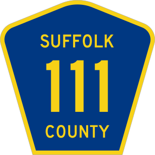
County Route 111 (CR 111) is a north–south county road in Suffolk County, New York, in the United States. It runs northwest and southeast from New York State Route 27 (NY 27) at exit 62 near Eastport to Interstate 495 (I-495) at exit 70 in Manorville. It serves as a connecting route between central Long Island and the Hamptons. The road is known as Captain Daniel Roe Highway, for Captain Daniel Roe (1740–1820) of Selden, who served in the French and Indian War and was a captain in the Revolutionary War. Within Manorville, the road is also known as Eastport Manor Road. It also appears on maps as Port Jefferson-Westhampton Road, for the communities in which the route was originally intended to have its north and south endpoints in.
This page is based on this Wikipedia article Text is available under the CC BY-SA 4.0 license; additional terms may apply. Images, videos and audio are available under their respective licenses.


