The River Tees forms the traditional border between Yorkshire and County Durham, passes through the Teesside Urban area built-up area, and has many crossings. The natural low-lying landscape of the surrounding landscape together with the development of shipping on the water way has led a number of unusual bridges being built. [1]
An early crossing of the Tees was made by the Romans, with the construction of a bridge at Piercebridge, along with a corresponding fortress. [2] The bridge was built on the route of Dere Street, and as a result it likely saw a great deal of military traffic going between the fortress at York and the northern frontier. [3] It was first built in wood around 90 AD, before being rebuilt in stone, possibly when the first bridge washed away. The use of the bridge may have continued into the sub-Roman period. [2]
Crossings of the Tees continued to be important in the journey from north to south, and vice versa, along the east coast, during the medieval period. [4] During the 13th century it was described as "the major obstacle to speedy travel out of the diocese of Durham southwards", with the contemporary fords, bridges and ferries proving particularly inconvenient in the winter period. [5] This included the Great North Road, for which the Croft Bridge was built in the 13th or 14th centuries. Yarm Bridge was built around 1400, by bishop Skirlaw. [4]
In 1771 a major flood on the Tees, along with others in the North-East, caused major damage to the river's bridges, completely destroying some. The Wynch Bridge, Supposedly the oldest suspension bridge in Europe, dating from 1741, was lifted from its moorings. The bridge in Gilmonby was recorded as being destroyed after having only been fully operational for 3 years. On the other hand, The medieval Yarm Bridge was not affected by the flood, despite every other building in the town being damaged. [6]
With the industrialisation of the area through the 19th century, many new bridges where needed closer to the ports mouth. [5] When the Stockton and Darlington railway, first opened in 1825, it was realised that the staiths at Stockton where two small to export the desired amount of coal. The decision was made to start exporting closer to the rivers mouth on the other bank, at Port Darlington (later Middlesbrough). This required the building of the first suspension railway bridge. [a] This moved the commercial centre of gravity of Teesside further down stream, where many future bridges would be built. [7]
By the end of that century there were 21 principal firms on and adjacent to the Tees in the Stockton and Thornaby area, with 36 firms in the Middlesbrough area. This led to the development of two of the most famous bridges on the river, The Transporter Bridge, in 1911, and the Newport Bridge, in 1934, both trying to balance the needs of travellers across the river with shipping up and down it. [5]
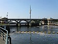
The following is a list of crossings of the River Tees, heading downstream, from source to its mouth in the North Sea. This includes road, rail, pipe and foot/cycle bridges and fords. [8] [9]
Crossing | Photo | Opened | Notes | Coordinates |
---|---|---|---|---|
Moor House Bridge | ![]() | 54°41′57″N2°22′23″W / 54.69917°N 2.37306°W | ||
Birkdale footbridge | ![]() | 1966 | Just downstream from Cow Green reservoir. [10] | 54°39′13″N2°17′23″W / 54.65361°N 2.28972°W |
Cronkley Bridge | ![]() | Private road bridge | 54°39′33″N2°12′55″W / 54.65917°N 2.21528°W | |
Holwick Head Bridge | ![]() | 1998 | The first bridge built here was in 1844, by the Duke of Cleveland. [11] | 54°38′59″N2°10′25″W / 54.64972°N 2.17361°W |
Wynch Bridge | ![]() | 1830 [12] | 
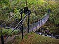
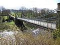
The original suspension bridge built on this spot was finished in 1741, was the first of its kind in Britain. That bridge was washed away in the Great Flood of 1771, with 2 more bridges being subsequently built there. [13] | 54°38′46″N2°9′2″W / 54.64611°N 2.15056°W [H 1] |
Scoberry Bridge | ![]() | 1971 | A bridge on this site was originally built in 1881, by public subscription. That bridge was damaged by flooding in 1942 and closed. Eventually rebuilt in 1971. There has been some controversy over who is responsible for upkeep. [14] [15] | 54°38′28″N2°8′26″W / 54.64111°N 2.14056°W |
Middleton Bridge | ![]() | 1853 | 
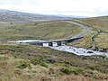
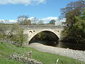
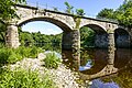
Replacing an earlier bridge, of 1811, which had collapsed before its completion. Consisting of one wide segmental arch, this bridge was under construction as early as 1810, using funds raised by public subscription. [16] [17] It now carries the B6277 road. | 54°37′21″N2°5′3″W / 54.62250°N 2.08417°W [H 2] [H 3] |
Beckstones Wath Footbridge | ![]() | 2002 [18] | Also known as the Millennium Bridge, built in response to campaign from residents in Eggleston and Mickleton, began in the 1980s. [19] The opening ceremony was attended by Lord Barnard and Earl of Strathmore. [18] | 54°36′47″N2°2′16″W / 54.61306°N 2.03778°W |
Eggleston Bridge | ![]() | 1450s | While incorporating parts of the original 15th century bridge, the structure as it now stands mostly dates to the 17th century. [20] Carries the B6281 road. | 54°36′15″N2°0′24″W / 54.60417°N 2.00667°W [H 4] |
Cotherstone Bridge | ![]() | 1932 | This bridge is close to the point where the Balder meets the tees. A bridge on this site was destroyed in an 1881 flood. [21] [22] | 54°34′38″N1°58′51″W / 54.57722°N 1.98083°W |
Crossing | Photo | Opened | Notes | Coordinates |
---|---|---|---|---|
Deepdale Aqueduct | ![]() | 1893 | 
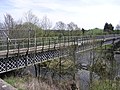
Also known as the "Silver Bridge" locally. A Victorian aqueduct, built for Stockton and Middlesbrough Waterboard by Head Wrightson, with a footpath on top. [23] [24] [25] It was designed by the engineer, James Mansergh. [26] | 54°32′45″N1°55′50″W / 54.54583°N 1.93056°W [H 5] [H 6] |
Barnard Castle Bridge | ![]() | 1569 | 
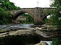
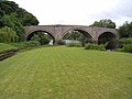
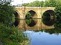
Replacing a much older bridge of an unknown age, the gothic bridge, is also known as "County Bridge". Like many bridges on the Tees it was severely damaged by the 1771 flood, and was rebuilt. [27] [28] [29] It now carries the A67 road. | 54°32′34″N1°55′38″W / 54.54278°N 1.92722°W [H 7] [H 8] [H 9] |
Thorngate Footbridge | ![]() | 1882 | Built to give access to the mills for textile workers. It was the second bridge on the site replacing a bridge that had been completed in the early 1870s. The first bridge, which was apparently cheaply built, collapsed in a storm in 1881, killing 2 onlookers. A second bridge was completed in 1882, but opened without ceremony. [30] [31] | 54°32′21″N1°55′33″W / 54.53917°N 1.92583°W [H 10] |
Abbey Bridge | ![]() | 1773 [32] | Built for John Sawrey Morritt as one single span. There are two emplacements at the south end of the bridge which are the sites of former toll houses, which were built with battlements and ornamental arrow loops. These buildings where demolished in the second half of the 20th century. [26] [32] | 54°31′47″N1°53′57″W / 54.52972°N 1.89917°W [H 11] |
Whorlton Bridge | ![]() | July 1831 [33] | The bridge had been started at this location before October 1829, but a flood on the 13th of that month destroyed all progress. John Green of Newcastle was tasked with the redesign, which he based on his previous work on the Scotswood suspension bridge. [33] | 54°31′35″N1°50′12″W / 54.52639°N 1.83667°W [H 12] [H 13] [H 14] |
Winston Bridge | ![]() | 1763 [34] | Originally built as part of a toll road from Staindrop to Richmond, and now carries the B6274. Designed by armature architect Sir Thomas Robinson. [34] | 54°32′29″N1°46′52″W / 54.54139°N 1.78111°W [H 15] [H 16] |
West Tees Railway Bridge | ![]() | 1856 | Pair of railway viaducts built as part of the former Darlington and Barnard Castle Railway. The railway had to be rerouted, to avoid Lord Barnard's Selaby Hall. The original bridges where destroyed in a flood in 1855. [35] [36] [37] | 54°33′3″N1°45′27″W / 54.55083°N 1.75750°W |
Gainford Railway Bridge | 1856 | 54°32′52″N1°44′47″W / 54.54778°N 1.74639°W | ||
Barforth Hall Bridge | ![]() | 1953 | 
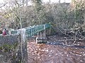
Built by a farmer to access a field, but over the years came to be used by the homeowners of Barforth Hall. A pier collapsed in 2002, and the bridge continued to deteriorate, with a dispute arising in 2009 about who owned the bridge, and who had the responsibility to upkeep it. [38] [39] [40] | 54°32′43″N1°44′42″W / 54.54528°N 1.74500°W |
Crossing | Photo | Opened | Notes | Coordinates |
---|---|---|---|---|
Piercebridge Pipe Bridge | ![]() | 1956 | water pipe | 54°32′7″N1°41′19″W / 54.53528°N 1.68861°W |
Piercebridge Bridge | ![]() | 16th century [H 17] [H 18] [H 19] | The outer arches date to the 16th century, with central arch dated to 1673. The bridge was widened in 1789. [41] | 54°32′5″N1°40′33″W / 54.53472°N 1.67583°W [H 17] [H 18] [H 19] |
A1(M) Bridge, Low Coniscliffe | 1961 | 
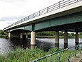
Built in 1961, in advance of the A1(M) Darlington bypass, which opened in 1965. As the part of the road around the river largely follows the alignment of the former Merrybent Railway, this bridge is sited at the location of a former railway bridge, which had been destroyed by fire in 1952. [7] [42] | 54°30′55″N1°37′18″W / 54.51528°N 1.62167°W | |
Blackwell Bridge | ![]() | 1832 [33] | Formerly carried the Great North Road, now carries the A66. Designed by John Green, it was his first masonry bridge. It was widened in 1961. [33] | 54°30′29″N1°35′3″W / 54.50806°N 1.58417°W [H 20] |
Croft Bridge | ![]() | 15th century | A167 road | 54°28′59″N1°33′16″W / 54.48306°N 1.55444°W [H 21] [H 22] |
Croft Viaduct | ![]() | 1840 | East Coast Main Line | 54°28′38″N1°33′10″W / 54.47722°N 1.55278°W [H 23] [H 24] |
Low Hail Bridge | ![]() | 1879 [43] | A privately owned bridge originally built to carry sewage to a treatment plant, that has since closed. Designed by civil engineer Robert Robinson, to an American design, it was completed in 1879. [44] [43] | 54°29′7″N1°31′20″W / 54.48528°N 1.52222°W |
Neasham Hall Bridge | ![]() | 1909 | Built for industrialist and politician Thomas Wrightson, to connect his country house, Sockburn Hall (also known as Neasham Hall), to the church in Eryholme, without having to use the existing ford. [45] | 54°28′42″N1°29′56″W / 54.47833°N 1.49889°W [H 25] |
Girsby Bridge | ![]() | 1870 | The owner of the land around the All Saints Church, Girsby, Theophania Blackett of Sockburn Hall, closed the church and the original wooden bridge near by, restricting both for her family's private use. Darlington Highway Board sued, and she was eventually forced to restore access to the church by building a new bridge, completed in 1870. [14] [44] | 54°28′7″N1°27′31″W / 54.46861°N 1.45861°W |
Fishlocks Bridge | 1987 [7] | Built by the local land owner to access his private land on either side of the river. Built on the site of an ancient ford, and down stream of a ferry. It was designed by Simpson Coulson and Partners, Stockton. [7] | 54°29′2″N1°27′36″W / 54.48389°N 1.46000°W | |
Over Dinsdale Bridge | ![]() | 1830s | 
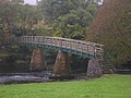
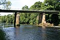
The present deck of bridge dates from 1956, placed on top of the original stone columns. Before that it had been a toll-bridge operated by the Over Dinsdale Estate. [46] | 54°29′47″N1°28′2″W / 54.49639°N 1.46722°W |
Barnard Castle is a market town on the north bank of the River Tees, in County Durham, England. The town is named after and built around a medieval castle ruin. The town's Bowes Museum has an 18th-century Silver Swan automaton exhibit and paintings by Goya and El Greco.
Darlington is a market and industrial town in County Durham, England. It is the main administrative centre of the unitary authority Borough of Darlington. The borough is a constituent member of the devolved Tees Valley area.
The River Tees, in England, rises on the eastern slope of Cross Fell in the North Pennines and flows eastwards for 85 miles (137 km) to reach the North Sea in the North East of England. The modern-day history of the river has been tied with the industries on Teesside in its lower reaches, where it has provided the means of import and export of goods to and from the North East England. The need for water further downstream also meant that reservoirs were built in the extreme upper reaches, such as Cow Green.
Yarm-on-Tees, or simply Yarm, is a market town in North Yorkshire, England. It lies on a meander of the River Tees, extending south-east to the River Leven and south to the village of Kirklevington. A civil parish in the Borough of Stockton-on-Tees, Yarm is near the towns of Stockton-on-Tees, 5 miles (8.0 km) to its northeast, and Darlington, 11 miles (18 km) to its west.
The Stockton and Darlington Railway (S&DR) was a railway company that operated in north-east England from 1825 to 1863. The world's first public railway to use steam locomotives, its first line connected collieries near Shildon with Darlington and Stockton in County Durham, and was officially opened on 27 September 1825. The movement of coal to ships rapidly became a lucrative business, and the line was soon extended to a new port at Middlesbrough. While coal waggons were hauled by steam locomotives from the start, passengers were carried in coaches drawn by horses until carriages hauled by steam locomotives were introduced in 1833.
Stockton-on-Tees is a market town in County Durham, England, with a population of 84,815 at the 2021 UK census. It gives its name to and is the largest settlement in the wider Borough of Stockton-on-Tees. It is part of Teesside and the Tees Valley, on the northern bank of the River Tees.
Piercebridge is a village and civil parish in the borough of Darlington and the ceremonial county of Durham, England. It is situated a few miles west of the town of Darlington. It is on the site of a Roman fort of AD 260–270, which was built at the point where Dere Street crossed the River Tees. Part of the fort is under the village green. The village is sited where the York-Newstead Roman road known as Dere Street crosses the River Tees.
Whorlton is a small village in County Durham, in England. It is situated near the River Tees and to the east of Barnard Castle.
The A67 is a road in England that links Bowes in County Durham with Crathorne in North Yorkshire. The road from Middlesbrough to Darlington was previously the A66 road, the road also starts and ends on the A66.
Croft-on-Tees is a village and civil parish in North Yorkshire, England. It has also been known as Croft Spa, and from which the former Croft Spa railway station took its name. It lies 11 miles (18 km) north-north west of the county town of Northallerton.
The Teesdale Way is a long-distance walk between the Cumbrian Pennines and the North Sea coast of North Yorkshire in England. The walk is 100 miles (160 km) in length; it links in with other long-distance walks such as the Pennine Way and the E2 European Walk between Harwich and Stranraer.
Piercebridge Roman Fort is a scheduled ancient monument situated in the village of Piercebridge on the banks of the River Tees in modern-day County Durham, England. There were Romans here from about AD 70 until at least the early 5th century. There was an associated vicus and bath house at Piercebridge, and another vicus and a villa south of the river at Cliffe. The Victorians used carved stones from this site when they built St Mary's church at Gainford. Part of the site is under Piercebridge village green.
The Darlington and Barnard Castle Railway, was an east–west railway line that connected Darlington and Barnard Castle in County Durham, England. Besides the main running line, it had two branches that headed south into Yorkshire that were only used for freight. The whole system opened up by July 1856 and was closed completely by 1966. The former Merrybent freight branch is now used as part of the A1(M) road that bypasses to the west of Darlington.
Piercebridge railway station was a railway station serving the village of Piercebridge in County Durham, England. It was located on the Darlington and Barnard Castle Railway. The station opened in 1856 and closed completely as part of the Beeching cuts in 1965.
Yarm Viaduct is a railway viaduct carrying the railways above the town of Yarm in North Yorkshire, England. It crosses the River Tees which forms the boundary between North Yorkshire and County Durham. The railway runs between Northallerton and Eaglescliffe, and was opened in 1852 as part of the extension of the Leeds Northern Railway to Stockton-on-Tees. The line and viaduct are currently owned and maintained by Network Rail and carries passenger traffic for TransPennine Express and Grand Central train operating companies. It also sees a variety of freight traffic.
The Skerne Bridge is a railway bridge over the River Skerne in Darlington, County Durham. Built in 1825 for the Stockton and Darlington Railway, it carried the first train on the opening day, 27 September 1825. It is still in use, being the oldest railway bridge in continuous use in the world. It is a Grade I listed building.
Croft Bridge is a road bridge over the River Tees, straddling the border between North Yorkshire and County Durham, in the north of England. The road over the bridge is now the A167, previously a second branch of the Great North Road, meeting the old road in Darlington. The bridge dates back to Medieval times, and is the setting for the awarding of a sword to the incoming Bishop of Durham.
Blackwell Bridge is a masonry road bridge spanning the River Tees between County Durham and North Yorkshire, in Northern England. The bridge was built in 1832, and widened in 1961. It carries the A66 road, which stems from the A66(M) spur off the A1(M) motorway. It used to be the main route north on the A1 until a bypass was opened in 1965.
Croft Viaduct is a railway bridge carrying the East Coast Main Line between Northallerton and Darlington in Northern England. The viaduct crosses the River Tees, the border between North Yorkshire and County Durham. Although it was an early example of a stone viaduct in the railway system, it is not the first true railway viaduct, however, it was the first railway viaduct in the United Kingdom to have been built with an oblique arch. It was grade II listed in 1988, and had overhead line equipment installed in the early 1990s.
{{cite book}}
: CS1 maint: location (link)