Croft Bridge

Last updated

Croft Bridge
Croft North Yorks A167 The Tees.jpg
Coordinates 54°28′59″N1°33′16″W / 54.4830°N 1.5544°W / 54.4830; -1.5544
OS grid reference NZ289098
Carries A167 road
Crosses River Tees
Locale Hurworth, County Durham
Croft, North Yorkshire
Heritage status Grade I listed
(Dual registered; see text)
Historic England numbers1116440
1131364
Preceded by Blackwell Bridge
Followed by Croft Viaduct
Characteristics
Total length330 feet (100 m)
History
Built14th century
Rebuilt1795
Location
Croft Bridge

Croft Bridge is a road bridge over the River Tees, straddling the border between North Yorkshire and County Durham, in the north of England. The road over the bridge is now the A167, previously a second branch of the Great North Road, meeting the old road in Darlington. The bridge dates back to Medieval times, and is the setting for the awarding of a sword to the incoming Bishop of Durham.

Contents

History

The origins of the bridge are in the 14th century, with documents referring to a bridge at the site in 1356 and 1361, though it is possible that either a ford or a timber bridge pre-dated the stone bridge. [1] [2] A grant of pontage was made in 1356 for repairs to the bridge as it had been damaged by severe flooding. [3] In 1531 it was described as being "...[a] grete bridge at Crofte, beinge of sixe myghte large pillars and of seven arches of stone worke..." [4] Until the building of Blackwell Bridge in 1832 (further upstream) all traffic to the south from Darlington had to use Croft Bridge. [5] [6] It remained an important crossing point between Yorkshire and County Durham; in late 1569, Sir Ralph Sadler and the Earl of Sussex, both loyal to Elizabeth I, gathered their forces at the bridge to ride northwards during the Rising of the North campaign. [7] [8]

The bridge is 330 feet (100 m) long, and it has seven arches, each arch being pointed and ribbed, though six of these arches are narrow-ribbed, and the smallest arch is on the southern (Yorkshire) side. [9] [10] [11] [3] A blue stone is a used as a marker on the third pier, and is inscribed with the following; "DUN CONTRIBVAT NORTH RID. COM EBOR. ET COM DTUNEL STATV. APVD SESS. VTBQe GEN. PAK. AN. DO. 1673." [12] Serious floods have the affected the bridge and its environs; in February 1753 severe flooding 15 feet (4.6 m) above the high-water mark caused the toll house to be swept away, taking £50 worth of toll-money with it, and in 1822, the water flooded the bridge to a depth of 15 feet (4.6 m) above its deck. [13]

Over the years, as the bridge became ruinous and dilapidated, arguments broke out between local authorities about who should maintain the bridge. In 1673, it was decreed that the third pier outwards from the Durham side would be the boundary marker between the two sides, with each district being responsible for the part of the bridge within their boundary. [4] This equates to 53 yards (48 m) on the Durham side, and 95 yards (87 m) on the Yorkshire side. [14] In 1795, the width of the bridge was extended by 15 feet (4.6 m) on the upstream side by noted architect John Carr. [15] [16] For the use of the bridge, tolls were charged between 1745 and 1879, although the turnpike trust were not responsible for the bridge or for 300 feet (91 m) either side of it, which caused a case to be pursued through the courts when a traveller with carts used the bridge but turned off in Croft-on-Tees onto the Richmondshire road. Having done so, he at no point used the road which was the responsibility of the turnpike, though they felt he should have paid. [17]

The river downstream of Croft Bridge has a different landscape to that upstream of the bridge; notwithstanding the industrial changes, but in pre-historic times, the valley below the bridge was subject to natural flooding from meltwater and also marine inundation. [18] Now, the bridge carries the A167 road between Northallerton and Darlington. This was originally a branch of the Great North Road from York to Newcastle, which met up with the old A1 road just after it crossed Blackwell Bridge south of Darlington. [19] [20] The bridge has a footpath on either side, and the road carriageway is 24 feet (7.3 m) across. [9]

The bridge is the setting for a handover whenever a new Bishop of Durham is elevated. The incoming bishop is greeted by the master of Sockburn manor with the falchion that was used to slay the Sockburn Worm. A few lines are said, and the bishop then gives the falchion back wishing the master of Sockburn, a long life, health and prosperity. [21] The ceremony used to be held at Neasham which is nearer Sockburn, but the ford there has become unpassable even in low water. [22] The ceremony was discontinued in 1826 when Durham ceased to be a Palatinate, but was revived by the investiture of John Habgood in 1973. [23] [24] [25]

Unusually, the bridge has two different listings with Historic England, both having Grade I listed status. The bridge at the County Durham side (Hurworth) was registered on 20 March 1967, and the Yorkshire side of the bridge, at Croft, was registered on 19 December 1951. [26] [27]

See also

Related Research Articles

<span class="mw-page-title-main">River Tees</span> East coast river of Northern England

The River Tees, in England, rises on the eastern slope of Cross Fell in the North Pennines and flows eastwards for 85 miles (137 km) to reach the North Sea in the North East of England. The modern-day history of the river has been tied with the industries on Teesside in its lower reaches, where it has provided the means of import and export of goods to and from the North East England. The need for water further downstream also meant that reservoirs were built in the extreme upper reaches, such as Cow Green.

<span class="mw-page-title-main">Yarm</span> Town and civil parish in North Yorkshire, England

Yarm, also referred to as Yarm-on-Tees, is a market town and civil parish in the Borough of Stockton-on-Tees, North Yorkshire, England. It is in Teesdale with a town centre on a small meander of the River Tees. To the south-east, it extends to the River Leven, to the south it extends into the Kirklevington.

<span class="mw-page-title-main">Piercebridge</span> Human settlement in England

Piercebridge is a village and civil parish in the borough of Darlington and the ceremonial county of Durham, England. The population of the civil parish as of the 2011 census was 113. It is situated a few miles west of the town of Darlington. It is on the site of a Roman fort of AD 260–270, which was built at the point where Dere Street crossed the River Tees. Part of the fort is under the village green. The village is sited where the York-Newstead Roman road known as Dere Street crosses the River Tees.

<span class="mw-page-title-main">Sockburn</span> Village in County Durham, England

Sockburn is a village and former civil parish, now in the parish of Neasham, in the Darlington district, in the ceremonial county of Durham, England. It is situated at the apex of a meander of the River Tees, to the south of Darlington, known locally as the Sockburn Peninsula. Today, all that remains of the village is an early nineteenth-century mansion, a ruined church and a farmhouse built in the late eighteenth century.

<span class="mw-page-title-main">Winston, County Durham</span> Village in County Durham, England

Winston is a village and civil parish in County Durham, England. It is situated approximately 6 miles (9.7 km) east of Barnard Castle, on a crossroads between the A67 and B6274 roads. According to the 2011 UK Census the population was 431, the parish includes the hamlets of Little Newsham and South Cleatlam.

<span class="mw-page-title-main">Hurworth Place</span> Village in County Durham, England

Hurworth Place is a village in County Durham, in England. It lies south of Darlington on the northern bank of the River Tees, opposite the village of Croft-on-Tees in North Yorkshire to which it is linked by Croft Bridge, a Grade I listed structure dating from the 14th century, which marks the county boundary. It is part of the civil parish of Hurworth.

<span class="mw-page-title-main">Hurworth-on-Tees</span> Human settlement in England

Hurworth-on-Tees is a village in the borough of Darlington, within the ceremonial county of County Durham, England. It is situated in the civil parish of Hurworth. The village lies to the south of Darlington on the River Tees, close to its meeting point with the River Skerne, and immediately adjoins the village of Hurworth Place, which forms part of the same civil parish.

<span class="mw-page-title-main">Dalton-on-Tees</span> Village and civil parish in North Yorkshire, England

Dalton-on-Tees is a village and civil parish in North Yorkshire, England, near the boundary with County Durham. According to the 2001 Census there were 318 people living in the parish in 120 houses. The population had decreased to 303 by the time of the 2011 Census.

<span class="mw-page-title-main">Croft-on-Tees</span> Village and civil parish in North Yorkshire, England

Croft-on-Tees is a village and civil parish in North Yorkshire, England. It has also been known as Croft Spa, and from which the former Croft Spa railway station took its name. It lies 11 miles (18 km) north-north west of the county town of Northallerton.

<span class="mw-page-title-main">Appersett</span> Hamlet in Wensleydale, North Yorkshire, England

Appersett is a hamlet in the Yorkshire Dales in the Richmondshire district of North Yorkshire, England one mile (1.6 km) west of Hawes. It lies on the A684 road and an unclassified road runs alongside Widdale Beck to connect with the B6255 road between Hawes and Ingleton.

<span class="mw-page-title-main">Girsby</span> Village and civil parish in North Yorkshire, England

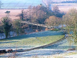
Girsby is a village and civil parish in the former Hambleton District of North Yorkshire, England. The village lies on high ground on the eastern bank of the River Tees. The population of the parish was estimated at 40 in 2015. The population as of the 2011 census remained less than 100. Details are included in the civil parish of Over Dinsdale.

In the folklore of Northumbria, the Sockburn Worm was a ferocious wyvern that laid waste to the village of Sockburn in Durham. It was said that the beast was finally slain by John Conyers. The tale is said by many to be the inspiration for Lewis Carroll's poem Jabberwocky which he wrote while in Croft-on-Tees and Whitburn.

<span class="mw-page-title-main">Croft Spa railway station</span> Former railway station in England

Croft Spa railway station was a railway station serving the settlements of Croft-on-Tees and Hurworth-on-Tees in County Durham, England.

The A1 road around Gateshead and Newcastle upon Tyne after arriving from the south as the A1(M) from its origin in London, currently runs from the A1(M) terminus at Birtley. It then swings to the west of both Gateshead and Newcastle via Coal House, Lobley Hill, Metrocentre, Swalwell, Blaydon Bridge, West Denton, Fawdon and Wideopen to Seaton Burn interchange before continuing north towards Edinburgh.

<span class="mw-page-title-main">Church of St Peter, Croft-on-Tees</span> Church in North Yorkshire, England

The Church of St Peter, Croft-on-Tees is a 12th century grade I listed parish church in the village of Croft-on-Tees in North Yorkshire, England. Artefacts and carvings inside the church are believed to have given rise to many of the characters created by Lewis Carroll, who as a child, attended St Peter's in the 1840s when his father was rector of the church.

<span class="mw-page-title-main">Yarm Viaduct</span> Railway viaduct over the River Tees in England

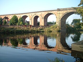
Yarm Viaduct is a railway viaduct carrying the railways above the town of Yarm in North Yorkshire, England. It crosses the River Tees which forms the boundary between North Yorkshire and County Durham. The railway runs between Northallerton and Eaglescliffe, and was opened in 1852 as part of the extension of the Leeds Northern Railway to Stockton-on-Tees. The line and viaduct are currently owned and maintained by Network Rail and carries passenger traffic for TransPennine Express and Grand Central train operating companies. It also sees a variety of freight traffic.

<span class="mw-page-title-main">2019 Yorkshire Dales floods</span> July 2019 floods in the Yorkshire Dales, England

In July 2019, parts of the Yorkshire Dales, in North Yorkshire, England, were subjected to above average rainfall for the time of year. The flash-flooding that followed affected many communities destroying bridges, sweeping roads away, causing landslips on railway lines and resulting in at least one public event being cancelled. The flooding even inundated the fire station in the town of Leyburn, in Wensleydale, whilst the crew were out helping those in need. The recovery took many weeks and months, with immediate help by the rescue services being bolstered by British Army personnel who assisted with the clean up.

<span class="mw-page-title-main">Blackwell Bridge</span> Road bridge in Northern England

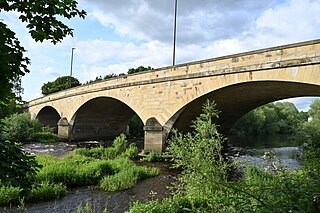
Blackwell Bridge is a masonry road bridge spanning the River Tees between County Durham and North Yorkshire, in Northern England. The bridge was built in 1832, and widened in 1961. It carries the A66 road, which stems from the A66(M) spur off the A1(M) motorway. It used to be the main route north on the A1 until a bypass was opened in 1965.

<span class="mw-page-title-main">Croft Viaduct</span> Railway bridge in Northern England

Croft Viaduct is a railway bridge carrying the East Coast Main Line between Northallerton and Darlington in Northern England. The viaduct crosses the River Tees, the border between North Yorkshire and County Durham. Although it was an early example of a stone viaduct in the railway system, it is not the first true railway viaduct, however, it was the first railway viaduct in the United Kingdom to have been built with an oblique arch. It was grade II listed in 1988, and had overhead line equipment installed in the early 1990s.

References

  1. Croft Conservation Area (PDF). richmondshire.gov.uk (Report). 1988. p. 3 via North Yorkshire Council (north.yorkshire.gov.uk).
  2. Betteney, Alan (2019). "Crossing the Tees" (PDF). teesarchaeology.com. Cleveland Industrial Archaeology Society & Tees Archaeology. p. 14. Retrieved 19 June 2024.
  3. 1 2 Jervoise, E. (1973) [1931]. The ancient bridges of the North of England. Wakefield: EP Publishing. p. 54. ISBN   0-85409-952-2.
  4. 1 2 Stanley, Oliver, ed. (2011) [1933]. "Part 1: England". British Bridges; an Illustrated Technical and Historical Record. London: ICE Publishing. p. 362. ISBN   978-0-7277-5069-3.
  5. Historic England. "Blackwell Bridge (Grade II) (1121318)". National Heritage List for England . Retrieved 21 June 2024.
  6. Rennison, Robert William; Barbey, M. F. (1996) [1981]. Civil engineering heritage. Northern England (2 ed.). London: T. Telford. p. 135. ISBN   0-7277-2518-1.
  7. Longstaffe 1854, p. 107.
  8. Lloyd, Chris (20 November 2002). "Echo memories - Boiled innards buried under a market square". The Northern Echo. p. 6. ISSN   2056-4287.
  9. 1 2 Barbey, M. F. (1981). Civil engineering heritage. Northern England. London: T. Telford. p. 46. ISBN   0-7277-0098-7.
  10. Longstaffe 1854, p. 41.
  11. Pevsner, Nikolaus (2002) [1966]. Yorkshire, the North Riding. London: Yale University Press. p. 133. ISBN   0-300-09665-8.
  12. Boyd, H. F. (7 August 1875). "Croft bridge". Notes and Queries. s5-IV (84): 118. doi:10.1093/nq/s5-IV.84.118d.
  13. Longstaffe 1854, pp. 19–20.
  14. Graham, Frank (1975). The bridges of Northumberland and Durham. Newcastle-upon-Tyne: Northern History. p. 5. ISBN   0-9028-3313-8.
  15. Harrison, D. F. (May 1992). "Bridges and Economic Development, 1300-1800". The Economic History Review. 45 (2). Economic History Society: 253. ISSN   0013-0117. JSTOR   2597622.
  16. Lloyd, Chris (14 July 2010). "A bridge to the past". The Northern Echo. Retrieved 19 June 2024.
  17. Robertson, Max A., ed. (1910). "Busey vs Storey". The English Reports. CX. Edinburgh: William Green & Sons: 392–397. OCLC   9031150.
  18. House, John W.; Fullerton, Brian (1960). Tees-side at mid-century: an industrial and economic survey. London: MacMillan. p. 30. OCLC   5704897.
  19. Harrison, David (2004). The bridges of medieval England: transport and society, 400-1800. Oxford: Clarendon Press. p. 60. ISBN   978-0-19-927274-7.
  20. Goddard, Frank (2004). The Great North Road: a guide for the curious traveller. London: Frances Lincoln. p. 111. ISBN   0711224463.
  21. Harper, Charles George (1901). The Great North Road, the old mail road to Scotland. London: Chapman & Hall. p. 111. OCLC   1045590440.
  22. "The Bridges of the Tees". BBC News. 13 November 2014. Retrieved 18 June 2024.
  23. Harper, Charles George (1901). The Great North Road, the old mail road to Scotland. London: Chapman & Hall. p. 112. OCLC   1045590440.
  24. "Ecclesiastical Intelligence". The Times. No. 26553. 6 September 1901. p. 7. ISSN   0140-0460.
  25. Rhea, Nicholas (7 June 2002). "Dragon-slayer's ancient welcome" . infoweb.newsbank.com. Retrieved 24 June 2024.
  26. Historic England. "Croft Bridge, Tees View (Grade I) (1116440)". National Heritage List for England . Retrieved 23 June 2024.
  27. Historic England. "Croft Bridge A167 (Grade I) (1131364)". National Heritage List for England . Retrieved 23 June 2024.

Sources