Wetherby Bridge

Last updated

Wetherby Bridge
Wetherby Bridge collage.png
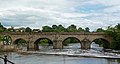
Wetherby bridge, downstream side (upper image), upstream side (lower image)
Coordinates 53°55′36″N1°23′10″W / 53.9266°N 1.38603°W / 53.9266; -1.38603
Carries A661
Crosses River Wharfe
Locale Wetherby, West Yorkshire
Other name(s)Wetherby Bridge
Characteristics
Design arch bridge
MaterialStone
No. of spans6
Piers in water4
History
Opened13th century
Location
Wetherby Bridge

Wetherby Bridge is a scheduled monument and Grade II-listed bridge over the River Wharfe in Wetherby, West Yorkshire, dating from the 13th century. [1] [2] The bridge connects Micklethwaite on the south bank to the town centre on the north. It formerly carried the A1 Great North Road but now carries the A661 Boston Road leading to Boston Spa and the south.

Contents

History

A aerial view of Wetherby Bridge Aerial photographs taken from the Wilderness car park, Wetherby (4th May 2021) 006.jpg
A aerial view of Wetherby Bridge
The three original bridges are evident from the change in height of the three arches seen here. Wetherby Bridge (May 2010) 002.jpg
The three original bridges are evident from the change in height of the three arches seen here.

The bridge has 13th-century origins. [3] It was rebuilt in the 17th century and widened twice, first in 1773 and in 1826 to a design by Bernard Hartley. Its repair has been a contentious political issue in the past.

In 1315 Eleanor de Percy petitioned Edward II for pontage for the bridge that she had undertaken to repair for redemption of the soul. An inquisition in York declared that 'nobody' was bound to repair the bridge and in 1316 Eleanor was granted pontage. [4] In 1599 a stone mason complained at quarter session that he was owed £4 13s 4d for its repair. The court ordered that £5 should be levied to pay him. In 1614 at the Knaresborough quarter sessions it was reported that the bridge's pavement had decayed, the court issued a levy of twenty marks to be collected from the Wapentakes of Barkston, Claro and Skyrack to repair the bridge. [5] In 1662 the bridge was described as being 'hazardous to passengers and cattle'; repairs were estimated to cost £260 which was paid from county rates and two Wetherby residents were appointed as surveyors. [6] Issues regarding the bridge were raised at the quarter sessions ten times over the following fifty years and £300 was expended on its maintenance. The bridge was an important logistical link for the coalfields of Garforth and Kippax to the south of the town and settlements north of the Wharfe. Coal wagons caused the road surface to deteriorate while the fast rising nature of the Wharfe exacerbated structural problems. [6]

Turner

J. M. W. Turner visited Wetherby in 1816 and painted the bridge. The vantage point he used is no longer usable owing to tree growth. [7]

Other river crossings in Wetherby

Until the first Wetherby by-pass was built and its new bridge was opened by the Minister for Transport Ernest Marples in the late 1950s, Wetherby Bridge was the only crossing in the area. The next upstream bridge was at Linton and downstream at Boston Spa. [8] The opening of the first by-pass bridge took the Great North Road away from the town. Wetherby Bridge is now one of three road crossings along with the first and second bypass bridges (opened in the late 1980s). Three bridges are usable by pedestrians; the Ings footbridge (built in the early 1970s), Wetherby Bridge and the first bypass bridge (the second one is inaccessible because of motorway regulations). Several bus routes cross the bridge.

Flooding

Wetherby Bridge is around a hundred yards downstream from Wetherby Weir. When the Wharfe rises the adjacent car park and low-lying land at the Wilderness flood. The bridge's arches can act as a barrier collecting debris and driftwood that can cause problems after the river level subsides.

Wetherby Bridge during Storm Eva with the river level reaching almost the top of the arches. Wetherby Bridge during the December 2015 floods (26th December 2015) 003.JPG
Wetherby Bridge during Storm Eva with the river level reaching almost the top of the arches.

War memorial

The town's war memorial designed by E. F. Roslyn is on the bridge. On the morning of Remembrance Sunday the bridge is closed to traffic for the wreath laying ceremony.

See also

Related Research Articles

<span class="mw-page-title-main">Boston Spa</span> Village and civil parish in West Yorkshire, England

Boston Spa is a village and civil parish in the City of Leeds in West Yorkshire, England. Situated 3 miles (5 km) south of Wetherby, Boston Spa is on the south bank of the River Wharfe across from Thorp Arch. According to the 2001 census, the parish had a population of 4,006 rising to 4,079 in the 2011 census.

<span class="mw-page-title-main">Wetherby</span> Town and civil parish in West Yorkshire, England

Wetherby is a market town and civil parish in the City of Leeds, West Yorkshire, England. It is close to West Yorkshire county's border with North Yorkshire, and lies approximately 12 miles from Leeds City Centre, 12 mi (19 km) from York and 8 mi (13 km) from Harrogate. The town stands on the River Wharfe, and for centuries has been a crossing place and staging post on the Great North Road midway between London and Edinburgh.

<span class="mw-page-title-main">River Wharfe</span> River in Yorkshire, England

The River Wharfe is a river in Yorkshire, England originating within the Yorkshire Dales National Park. For much of its middle course it is the county boundary between West Yorkshire and North Yorkshire. Its valley is known as Wharfedale.

<span class="mw-page-title-main">Wharfedale</span> Valley in Yorkshire, England

Wharfedale is the valley of the upper parts of the River Wharfe and one of the Yorkshire Dales. It is situated in North Yorkshire, and the cities of Leeds and Bradford in West Yorkshire. It is the upper valley of the River Wharfe. Towns and villages in Wharfedale include Buckden, Kettlewell, Conistone, Grassington, Hebden, Bolton Abbey, Addingham, Ilkley, Burley-in-Wharfedale, Otley, Pool-in-Wharfedale, Arthington, Collingham and Wetherby.</ref> Beyond Wetherby, the valley opens out and becomes part of the Vale of York.

<span class="mw-page-title-main">Tadcaster</span> Town in North Yorkshire, England

Tadcaster is a market town and civil parish in North Yorkshire, England, 15 miles (24 km) north-east of Leeds and 10 miles (16 km) south-west of York. Its historical importance from Roman times onward was largely as the lowest road crossing-point on the River Wharfe until the construction of the A64 Tadcaster by-pass some 660 yards (600 m) to the south, in 1978. There are two rail crossings downstream of the town before the Wharfe joins the River Ouse near Cawood.

<span class="mw-page-title-main">Collingham, West Yorkshire</span> Village and civil parish in West Yorkshire, England

Collingham is a village and civil parish 2 miles (3 km) south-west of Wetherby in West Yorkshire, England. It is in the City of Leeds metropolitan borough. The population of the civil parish as of the 2011 census was 2,991.

<span class="mw-page-title-main">A168 road</span> Road in North Yorkshire, England

The A168 is a major road in North Yorkshire, England. It runs from Northallerton to Wetherby, acting as a local access road for the A1(M).

<span class="mw-page-title-main">Thorp Arch</span> Village and civil parish in West Yorkshire, England

Thorp Arch is a village and civil parish near Wetherby, West Yorkshire, England in the City of Leeds metropolitan borough.

<span class="mw-page-title-main">Ebor Way</span> Footpath in Yorkshire, England

The Ebor Way is a 70-mile (112 km) long-distance footpath from Helmsley, North Yorkshire to Ilkley, West Yorkshire, via the city of York, England. It takes its name from Eboracum, the Roman name for York.

<span class="mw-page-title-main">Pontage</span> Toll levied for the building or repair of bridges

Pontage was a toll levied for the building or repair of bridges dating to the medieval era in England, Wales and Ireland.

<span class="mw-page-title-main">Micklethwaite, Wetherby</span> Area in Wetherby, West Yorkshire, England

Micklethwaite is an area of Wetherby on the south bank of the River Wharfe in West Yorkshire, England. It is in the City of Leeds metropolitan borough. It was once a separate village but has been incorporated into Wetherby. In 2004 150 houses were constructed on Micklethwaite Farm. It is the location of Wetherby's police station, the former magistrates' court, the leisure centre, Wetherby Athletic Football Club and a Mercure Hotel.

<span class="mw-page-title-main">History of Wetherby</span>

The recorded history of Wetherby, a market town in the City of Leeds metropolitan borough, West Yorkshire, England, began in the 12th and 13th centuries, when the Knights Templar and later the Knights Hospitallers were granted land and properties in Yorkshire. The preceptory founded in 1217 was at Ribston Park. In 1240, the Knights Templar were granted by the Royal Charter of Henry III the right to hold a market in Wetherby. The charter stated the market should be held on Thursdays, and an annual fair was permitted lasting three days over the day of St James the Apostle.

<span class="mw-page-title-main">Wetherby Ings</span> Water meadows in West Yorkshire, England

Wetherby Ings are water meadows, by the River Wharfe now used as parkland in Wetherby, West Yorkshire, England. The ings on the north and south bank are used as parkland and for sports grounds for the town's football and rugby league teams. The area is liable to flooding during heavy rain and the river has broken its banks frequently.

<span class="mw-page-title-main">Wetherby (Linton Road) railway station</span> Disused railway station in West Yorkshire, England

Wetherby railway station was built on the North Eastern Railway's Cross Gates to Wetherby Line on Linton Road. It replaced an earlier station on York Road which had opened on 1 May 1876.

<span class="mw-page-title-main">The White Rose Way</span> Long-distance footpath in England

The White Rose Way is a 104 miles (167 km) walking trail in England from Leeds, West Yorkshire to Scarborough, North Yorkshire. It was created in 2011 by local author Paul Brown. The walk starts at the foot of the Black Prince Statue in City Square with the finish line being at the former harbour-side Tourist Information Centre in the South Bay, Scarborough.

<span class="mw-page-title-main">Tadcaster railway station</span> Disused railway station in North Yorkshire, England

Tadcaster railway station was on the Harrogate to Church Fenton Line in Tadcaster, North Yorkshire, England.

<span class="mw-page-title-main">Tadcaster Bridge</span> Bridge in North Yorkshire, England

Tadcaster Bridge or Wharfe Bridge spans the River Wharfe in Tadcaster, North Yorkshire, England. The road bridge is believed to date from around 1700. It is the main route connecting the two sides of the town and one of two road crossings in the town, the other being the bridge for the A64 bypass. Tadcaster Bridge partially collapsed on 29 December 2015 after flooding that followed Storm Eva, and reopened on 3 February 2017.

<span class="mw-page-title-main">Linton Bridge</span> Grade II listed road bridge in West Yorkshire, England

Linton Bridge carries the minor road that links Collingham and Linton over the River Wharfe near Wetherby in West Yorkshire, England.

<span class="mw-page-title-main">Thorp Arch Bridge</span> Road bridge in West Yorkshire, England

Thorp Arch Bridge is a stone arch bridge opened in 1770 across the River Wharfe linking the West Yorkshire villages of Boston Spa on the southbank and Thorp Arch on the north.

<span class="mw-page-title-main">National Cycle Route 665</span> Cycle route in the United Kingdom

National Cycle Network (NCN) Route 665 is a Sustrans route from Wetherby to South West York. Two sections of the route are open. As of summer 2020 the route is not fully signed. The central section between Tadcaster and Newton Kyme is still a proposal.

References

  1. West Yorkshire Archaeology Advisory Service. Wetherby Conservation Area, retrieved on 4 August 2007.
  2. Historic England. "WETHERBY BRIDGE (OVER RIVER WHARFE) WITH ATTACHED WAR MEMORIAL (1313468)". National Heritage List for England . Retrieved 12 January 2016.
  3. Unwin 1987 , p. 1
  4. Unwin 1987 , p. 26
  5. Unwin 1987 , p. 43
  6. 1 2 Unwin 1987 , p. 60
  7. "Wetherby Bridge". Welcome to Yorkshire. Retrieved 27 December 2015.
  8. The Archive Photographs Series: Wetherby ISBN   0-7524-0328-1 (published 1995) page 24

53°55′36″N1°23′10″W / 53.9266°N 1.3860°W / 53.9266; -1.3860