This is a list with images of some of the structures in the historic mining town of Oatman, Arizona which is located in the Black Mountains of Mohave County. Two of the structures are listed in the National Register of Historic Places.
The Black Mountains of northwest Arizona are an extensive long mountain range. The Hualapai Native-American Tribe inhabited the area. Tensions between the Hualapai people and settlers began with encroachment of Indian lands. Between 1867 and 1869, the Hualapai were at war with the American settlers from the east coast who lived in this area after the death of the prominent Yavapai leader Anasa. The United States Army arrived in the defense of the settlers in what now is known as the Hualapai War. Skirmishing continued for almost two more years in the area after the majority of the Hualapais surrendered due to an outbreak of dysentery and whooping cough in 1869.[1][2]
Vivian tent city
John Thomas Moss was a frontiersman and prospector from Utica, New York who learned the languages of many of the tribes in the area. In 1862, he discovered gold in the Black Mountains and staked a claim in what became known as the Moss Mine. In 1863, he went into the Hualapai Mountains and organized the profitable Wauba Yuma Mining District.[3][4]
Soon after a tent city was established and named "Vivian" nestled in the southern portion of the Black Mountain range.[5] The tent city of Vivian grew as miners and prospectors continued to arrive in the area. Burros, which is the Spanish word for Donkey, were used by the miners to carry essential supplies, including rock and metals in those days. The wild burros, roaming the streets of Oatman today, are the offspring of the burros that were let lose after they became useless to the miners as resources ran out and mines closed.[6]
In 1902 John Durlin built the Drulin Hotel which provided shelter and food to many of the miners in the area. The hotel, which was renamed "Oatman Hotel" in 1960, is the only historic two-story adobe building in Mohave County.[7] By 1904 the Vivian Mining Company began operations and a Post Office was established. Between 1903 and 1905, the town and mines were served by a narrow gauge rail line. The narrow gauge trail line ran 17 miles to the Colorado River near Needles, California.[8]
Oatman
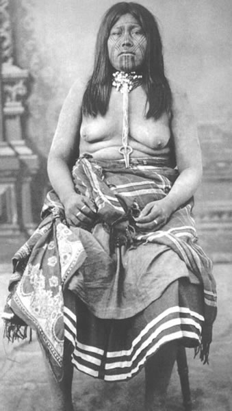
Olive Oatman
In 1909, Vivian was formally named Oatman in honor of Olive Oatman, a 14-year-old girl whose family was attacked by a small group from a Native American tribe believed to be Tolkepayas (Western Yavapai). All were killed except for three of the children: Lorenzo, age 15 (who was left for dead), Olive, and Mary Ann, age 7, who were taken to be slaves for the Yavapais.[9] Olive and Mary Ann were sold as slaves to the Mohave who tattooed both girls on their chins and arms.[10] Olive survived the ordeal, but her younger sister Mary Ann died while in captivity. Eventually. Olive was released when the Mohaves were told by a messenger that the whites would destroy the Mohaves if they did not release her. The trade items included were blankets and a white horse.[11][12]
In 1915, another boom was provided to the settlement when two miners struck a gold find. However, in 1921, a fire of huge proportions consumed many of the structures in the town. The townspeople worked hard to rebuild the small town. Five years later the main mining company, United Eastern Mines, shut down operations for good.[8][7] The town continued to survive due to the travelers who passed through the old U.S. Route 66 which was built in 1920. The town's economy was once again affected when the route became what is now Interstate 40 and was completely bypassed in 1953.[8][7]
In 1995, the Gold Road Mine was reopened, however the decline of gold prices resulted in its closure in 1998. A renewed interest in the town and travel in Route 66 began with the growth of the nearby gaming town of Laughlin, Nevada. The hotels in Laughlin promotes visits to the town. Oatman is now a tourist attraction.[13][8][7]
Cool Springs
Before reaching Oatman through the historic Route 66, there is a gas station, the Cool Springs camp and service station, which originally was built in 1920. The original building burned to the ground in the 1960s and a new one was rebuilt in its place. The pillars are the only items which remained from the original structure. Part of the movie "Universal Soldier" was filmed there.[14] Between the station and Oatman there is a stone bridge on the narrow Route 66. The stone bridge is located in what is known as "Bloody 66" in Sitgreaves Pass. According to the book “The Big Roads”, authored by Earl Swift, the 18-foot stone bridge that crossed the wash was too narrow for two speeding cars to pass safely in opposite directions. One car would hit another or worse impale itself, and sometimes its driver, on the wooden guard rail.[15]
National Register of Historic Places
The National Register of Historic Places includes:
The Oatman Hotel – listed as the "Durlin Hotel" on August 25, 1983, reference: #83002988.
The Oatman Drug Company Building – listed on April 6, 2006, reference: #05001064.
This page is based on this Wikipedia article Text is available under the CC BY-SA 4.0 license; additional terms may apply. Images, videos and audio are available under their respective licenses.


