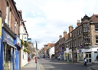
List of mills in Derbyshire

Last updated

Map all coordinates using: OpenStreetMap

This is a list of the cotton and other textile mills in Derbyshire, England. The first mills were built in the 1760s in the Derwent Valley by Arkwright and Strutt, and were powered by the water of the River Derwent. The abundance of water from the River Etherow and its tributaries led to mills being built in Longdendale and Glossopdale, and similarly along the River Wye in Millers Dale. As the industry developed, the mills changed hands, were demolished, were converted to use steam, or consolidated into larger units. They changed their names and their functions. Water-powered mills were smaller than the later steam-powered mills found in Greater Manchester. Parts of Derbyshire have been subsumed into Stockport.

Contents

Longdendale

Derwent Valley

This includes Derby, and Belper
NameArchitectLocationBuiltDemolishedServed
(Years)
North Mill Belper   53°01′45″N1°29′11″W / 53.0291°N 1.4864°W / 53.0291; -1.4864 (North Mill) 1786/1804
Belper mill.jpg 1186846 Notes: The original North Mill, completed in 1786 by Jedediah Strutt, was destroyed by fire in 1803. Its replacement was built in 1804 by his son, William Strutt, on the foundations of the old mill and is one of the oldest surviving examples of an iron-framed 'fire-proof' building in the world. [1]
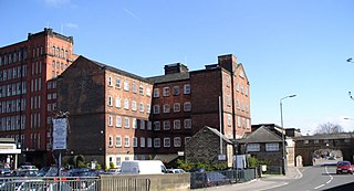
East Mill Belper   53°01′44″N1°29′09″W / 53.0288°N 1.4857°W / 53.0288; -1.4857 (East Mill) 1912 Standing 111
Belper - East Mill - geograph.org.uk - 736044.jpg 1336982 Notes: A fortress-like, seven-storey building, 24 bays by 11, with four corner turrets with Italianate tower, it was constructed by the English Sewing Cotton Company in 1912. [1]
Round Mill Belper   53°01′41″N1°29′11″W / 53.0280°N 1.4865°W / 53.0280; -1.4865 1816 207
Notes: Demolished; designed for bale-breaking.
West Mill Belper   53°01′42″N1°29′12″W / 53.0284°N 1.4866°W / 53.0284; -1.4866 (West Mill) 1797 226
Notes: Demolished.
2nd South Mill Belper   53°01′42″N1°29′12″W / 53.0284°N 1.4866°W / 53.0284; -1.4866 (South Mill) 1811 212
Notes: Demolished.
Junction Mill Belper   53°01′42″N1°29′12″W / 53.0284°N 1.4866°W / 53.0284; -1.4866 (Junction Mill)
Notes: Demolished.
Reeling Mill Belper   53°01′42″N1°29′12″W / 53.0284°N 1.4866°W / 53.0284; -1.4866 (Reeling Mill) 1807 216
Notes: Demolished.
de Bradelei Mill Belper   53°01′18″N1°29′06″W / 53.0216°N 1.4849°W / 53.0216; -1.4849 (de Bradelei Mill)
Notes: George Brettle & Co., makers of hosiery. [2]
Unity Mill Derwent St, Belper   53°01′25″N1°29′10″W / 53.0236°N 1.4861°W / 53.0236; -1.4861 (Unity Mill) mid 19th century
1087354 Notes: A corn mill converted to cotton spinning by John Strutt (1853), then furniture manufacture. [2]
1850 Gritstone warehouse Belper  
Notes: The Ward, Sturt and Sharp hosiery warehouse from 1850. [2]
Boar's Head Cotton Mills Darley Abbey   52°56′38″N1°28′28″W / 52.9438°N 1.4745°W / 52.9438; -1.4745 1782-1862
Boar's Head Mills, Darley Abbey (geograph 2329112).jpg Notes: The Evans Mills produced high-quality 'Boar's Head' sewing cotton. Long Mill was built in 1782, operational in 1788, then burnt down in 1789 and was rebuilt in 1790. The top floor was used as a schoolroom for their child workers. It connects to West Mill (1821), Middle Mill (1804–05) and East Mill (1811). Separate is a Gassing Shed (1862) where the thread was singed, and the North Mill (1835). The free-standing engine house has been demolished but the chimney remains. [3]
Cromford Mill Cromford   53°06′31″N1°33′21″W / 53.1085°N 1.5557°W / 53.1085; -1.5557 1771
Cromford 1771 mill.jpg 1248010 Notes: The first cotton mill set up by Richard Arkwright to use the "Spinning Jenny" to make cotton thread. Later a paint factory.
Bath Street Mill Derby   1851 172
Bath Strett Mills Derby 708578 94511940.jpg Notes:
Queen Street Mill Derby  
Lombe's Mill Derby   18th century
Lombe's Mill print Darley-Factory p105.png Notes:
Masson Mill Matlock Bath   53°06′44″N1°33′44″W / 53.1121°N 1.5621°W / 53.1121; -1.5621 1783 240
Main entrance, Masson Mill - geograph.org.uk - 1408625.jpg Notes:
Milford Mills Milford   53°00′18″N1°28′53″W / 53.0049°N 1.4813°W / 53.0049; -1.4813 ('Milford Mills')
Milford Mills - geograph.org.uk - 450041.jpg Notes: The Milford mill complex, built by Jebediah and William Strutt, spanned the A6 toll road, upstream from Milford bridge. Started in the 1780s to spin cotton, it expanded to include bleaching and dyeing mills. William built the warehouse in 1793, experimenting to produce a multi-storey fire-proof mill.The extant dyehouse near the bridge was a later more successful attempt. [4]

River Wye


NameArchitectLocationBuiltDemolishedServed
(Years)
Cressbrook Mills Cressbrook SK173726 53°15′00″N1°44′31″W / 53.250°N 1.742°W / 53.250; -1.742 ("Cressbrook Mills") 1815 208
Cressbrook Mill - geograph.org.uk - 157740.jpg 1158897 Notes: [5]
Litton Mill Millersdale  SK161729 53°15′11″N1°45′36″W / 53.253°N 1.760°W / 53.253; -1.760 ("Litton Mill")
Litton Mill 0546.JPG Notes: [5]
Lumford Mill Bakewell  53°13′05″N1°41′01″W / 53.2180°N 1.6836°W / 53.2180; -1.6836 ("L8umford Mill")
1346790 83515d8c.jpg Notes:
Rowsley Mill  

The mills of New Mills and Rowarth


NameArchitectLocationBuiltDemolishedServed
(Years)
St. George's Works (Wellington New Mill)  [6]
Grove Paper Mill  53°21′44″N2°00′23″W / 53.3621°N 2.0065°W / 53.3621; -2.0065 ("Grove Paper Mill")
Ned Mill  [6]

Rowarth Brook


NameArchitectLocationBuiltDemolishedServed
(Years)
Top Mill Rowarth  [6]
Grove Mill Rowarth 
Notes: A print works [5] [6]
Froggatt's Mill Rowarth  [6]
Lower Mill Rowarth  [6]
Little Mill Rowarth SK011889 53°23′49″N1°59′06″W / 53.397°N 1.985°W / 53.397; -1.985 ("Little Mill ") 1930 93
Notes: The oldest-known mill in the New Mills area, built between the inn and the brook. It was a two-storey building powered by a waterwheel. The remains were swept away by the flood of 18 June 1930. [5] [6]
Ringstones (Alma Mount) Rowarth  [6]
Bate Mill Thornsett SK007868 53°22′41″N1°59′28″W / 53.378°N 1.991°W / 53.378; -1.991 ("Bate Mill ")
Notes: 1889: bleachers and dyers [6] [7]

River Goyt


NameArchitectLocationBuiltDemolishedServed
(Years)
Torr Vale Mill
aka Stafford's Mill
Lowe's Mill
The Torrs, New Mills  SJ999854 53°21′53″N2°00′11″W / 53.3648°N 2.0030°W / 53.3648; -2.0030 ("Torr Vale Mill
aka Stafford's Mill
Lowe's Mill"
)
1788 **** 212
New Mills, Torr Vale above 1749.JPG 1119721 Notes: [6]
Torr Mill,
a.k.a. Schofield's Mills
The Torrs, New Mills   53°21′50″N2°00′01″W / 53.3640°N 2.0002°W / 53.3640; -2.0002 ("Torrs Hydro, New Mills") 1838 1912 74
Notes: Spindleage: (1811) 14 mules, 2802 spindles, (1848) 20 mules, 13,792 spindles, boiler by Butterley. The first mill was built in 1794 by Samuel Schofield, for cotton spinning. It was powered by water. It was burnt down on 22 October 1838 while being operated by John Sheldon. The second bigger five-storey mill was built immediately on the same site. A chimney was added in 1846, suggesting that this mill was operated by steam and water. The mill was occupied by Josiah Mellor and John Roberts until 1857, when it passed to Messrs Hibbert and Alcock cotton spinners. In June 1873, the mill was floated with capital of £4000 as a co-operative venture known as the Torr Mill Spinning Company. In 1883 a new boiler was installed. The mill became unviable in 1900 and the machinery was removed. Two further firms attempted to use the mill but it was destroyed by fire on 2 December 1912. The leat for this mill passed under the Queens Road bridge and in a trough over the River Sett, and the tail race continued downstream under the Union Road bridge. Torrs Hydro has been built on the site. [6] [8] [9]
Rock Mill, a.k.a. Crowther's Mill The Torrs, New Mills,   53°21′54″N2°00′08″W / 53.3650°N 2.0022°W / 53.3650; -2.0022 ("Rock Mill, a.k.a. Crowther's Mill") [6]
Hague Bar (Hague/Haigh) Mill  [6]
Strines Printworks Strines, Marple,   53°22′35″N2°02′23″W / 53.3765°N 2.0396°W / 53.3765; -2.0396 ("Strines Printworks") [6]

River Sett

Also known as River Kinder.


NameArchitectLocationBuiltDemolishedServed
(Years)
Hyde Bank (Beard) (Goddard Mill) Hide Bank, New Mills SK001856 53°22′01″N2°00′00″W / 53.367°N 2.000°W / 53.367; -2.000 ("Hyde Bank (Beard) (Goddard Mill)") 1785 Standing 238
Beard Mill - geograph.org.uk - 277906.jpg Notes: The first mill was a woollen mill which burnt down. This four-storey gritstone former cotton mill, on Hyde Bank Road straddling the River Sett, dates from the early 19th century. The mill used to be a finishing mill for W S Lowe & Sons, but has been shut for a number of years. It has now been converted into flats and the bridge on the left is a recent replacement. The first cotton spinning mill was constructed in 1785; before that an early woollen and fulling occupied the site. Now in multiple occupation. [6] [10]
Birch Vale Printworks SK 020868 53°22′41″N1°58′16″W / 53.378°N 1.971°W / 53.378; -1.971 ("Birch Vale Printworks") ,   [6]
Garrison Works Thornsett,  SK 015869 53°22′44″N1°58′44″W / 53.379°N 1.979°W / 53.379; -1.979 ("Garrison Works ") [6]
London Place (Watford Bridge Printworks)
Watford Mill from Mellor Rd, New Mills in 1963 Watford Mill from Mellor Rd, New Mills in 1963.jpg
Watford Mill from Mellor Rd, New Mills in 1963
Sett Valley SK 005863 53°22′26″N1°59′38″W / 53.374°N 1.994°W / 53.374; -1.994 ("London Place (Watford Bridge Printworks)")
Notes: 1889: calico printing. [6] [7]
Salem (Bower) Mill SK002858 53°22′08″N1°59′53″W / 53.369°N 1.998°W / 53.369; -1.998 ("Salem (Bower) Mill")
Notes: Two-storey gritstone buildings, formerly a cotton mill of the 1780s and later a chemical works. Next to the medieval manorial corn mill. [6]
Barnes Top Shop (Torr Top Mill) (Midland Ironworks)  [6]
Grove (Wyatt's) (Barnes) Mill  [6] 1790 76

Peak Forest Canal


NameArchitectLocationBuiltDemolishedServed
(Years)
Brunswick Mill/Works Newtown, New Mills SJ997849 53°21′40″N2°00′22″W / 53.361°N 2.006°W / 53.361; -2.006 ("Brunswick Mill/Works ")
New Mills, Brunswick Mill (geograph 3145693).jpg Notes: Three- and four-storey gritstone mill building (datestone 1883) on the Peak Forest Canal. Formerly a cotton mill, bought in 1868 by the Quaker, Edward Godward 1841–1908, who became the first chairman of New Mills UDC, in 1894. Spindleage 1887: 11,000 kitting and sewing cottons. It was extended and used as a sweet factory by Swizzels Matlow. [5] [6] [7]
Victoria Mill Newtown, New Mills  1860 125
Remains of Victoria Mill, Newtown - geograph.org.uk - 1211546.jpg Notes: 1889: Josseph Froggatt & Son, 1,000 spindles. Victoria Mill was built in 1860 and when it closed in 1985 was the last cotton spinning mill to work in New Mills. It was partly destroyed by fire on 13 March 1986 and has subsequently been largely demolished. There is a picture of it just after the fire on the front of New Mills – A look back at its Industrial Heritage (1997). [6] [7]
Woodside (New Brunswick) Mill Newtown, New Mills  [6]
Albion Mill Newtown, New Mills SJ996848 53°21′36″N2°00′25″W / 53.360°N 2.007°W / 53.360; -2.007 ("Albion Mill ")
Albion Mill - geograph.org.uk - 277892.jpg Notes: Three- and four-storey gritstone mill building of 1859. This was the first of a group of mid-19th century cotton mills erected around the Peak Forest Canal. [5] [6]
Warks Moor Mill Newtown, New Mills 
Notes: 1889: Francis Rowbottom, 8000 spindles [6] [7]
Redmoor Mill Newtown, New Mills  [6]
Albert Mill Newtown, New Mills 
Notes: 1889:Bleachers and Dyers and paper maker [6] [7]
Some of these mills are occupied by Swizzels Matlow. [11] One mill was built about 1843, and part was destroyed by fire in 1983. Swizzels Matlow's address is Albion Road.

Other


NameArchitectLocationBuiltDemolishedServed
(Years)
Brunt Mill Longnor,  SK085646 53°10′41″N1°52′26″W / 53.178°N 1.874°W / 53.178; -1.874 ("Brunt Mill") [12] [5]
Calver Mill Calver  SK 247745 53°16′01″N1°37′52″W / 53.267°N 1.631°W / 53.267; -1.631 ("Calver Mill") 1804 Standing 119
Calver Mill - geograph.org.uk - 347691.jpg 1068650 Notes: The mill opened in 1778, built by John Gardom of Bakewell and John Pares of Leicester on the site of a corn mill. To use Arkwright's two patents there was an initial premium of £7000 and an annual royalty of £1000. By 1785, the mill had been developed and stood at three storeys. In 1799, however, the River Derwent washed away Calver Bridge and took part of the mill with it; shortly after the mill was burned to the ground. A new seven-storey mill was subsequently constructed, and began production in 1804. By 1830 it employed 200 workers some being parish apprentices. In 1833 new, larger, waterwheels were constructed. [13] Spinning finished in 1923. In the 1980, the mill featured in Pat Reid's television drama Colditz , standing in for Colditz Castle. [14] [5]
Clough Mill Little Hayfield SK032882 53°23′28″N1°57′11″W / 53.391°N 1.953°W / 53.391; -1.953 ("Clough Mill")
Clough Mill, Little Hayfield - geograph.org.uk - 1205355.jpg Notes: A former water-powered and later steam-powered textile mill. Converted to apartments in 1989. [5]
Edale Mill Edale SK 134854 53°21′54″N1°48′00″W / 53.365°N 1.800°W / 53.365; -1.800 ("Edale Mill") 1795 Standing 139
Edale Mill (geograph 2366416).jpg 1096614 Notes: This mill has now been converted into apartments. The first mill was a corn mill driven by the River Noe. In 1795 Nicholas Cresswell enlarged the building, taking James Harrison, Robert Blackwell and Joseph Fletcher as partners. A three-storey building with external stair column, the present mill was added a little later. The mill which passed to the Fine Spinners & Doublers Ltd, and cotton manufacturing ceased here in 1934. Many of the women workers came from Castleton, walking to the mill via Hollins Cross at a height of 1,250 feet (380 m). This was a climb of 650 feet (200 m); during bad weather they would sleep at the mill. [5] [15]
Haarlem Mill Derby Rd, Wirksworth   1780 Standing 243
Haarlem Mill - geograph.org.uk - 2326070.jpg 1335116 Notes: Cotton spinning mill erected by Richard Arkwright
Hayfield Fulling Mill Hayfield,  SK055863 53°22′26″N1°55′08″W / 53.374°N 1.919°W / 53.374; -1.919 ("Hayfield Fulling Mill") [5]
Lumb Mill
Lambs Hole
Kettleshulme,  SJ 988804 53°19′16″N2°01′08″W / 53.321°N 2.019°W / 53.321; -2.019 ("Lumb Mill
Lambs Hole"
)
[5]
Phoside Mill Hayfield SK037859 53°22′12″N1°56′46″W / 53.370°N 1.946°W / 53.370; -1.946 ("Phoside Mill")
Derelict building at Phoside Farm (geograph 2491893).jpg Notes: [5]
Primrose Mill Hayfield,  SK031880 53°23′20″N1°57′18″W / 53.389°N 1.955°W / 53.389; -1.955 ("Primrose Mill") [5]
Walk Mill Hayfield,  SK037870 53°22′48″N1°56′46″W / 53.380°N 1.946°W / 53.380; -1.946 ("Walk Mill") [5]

Related Research Articles

<span class="mw-page-title-main">Derwent Valley Mills</span> World Heritage site in Derbyshire, England

Derwent Valley Mills is a World Heritage Site along the River Derwent in Derbyshire, England, designated in December 2001. It is administered by the Derwent Valley Mills Partnership. The modern factory, or 'mill', system was born here in the 18th century to accommodate the new technology for spinning cotton developed by Richard Arkwright. With advancements in technology, it became possible to produce cotton continuously. The system was adopted throughout the valley, and later spread so that by 1788 there were over 200 Arkwright-type mills in Britain. Arkwright's inventions and system of organising labour was exported to Europe and the United States.

<span class="mw-page-title-main">River Derwent, Derbyshire</span> River in Derbyshire, England

The Derwent is a river in Derbyshire, England. It is 50 miles (80 km) long and is a tributary of the River Trent, which it joins south of Derby. Throughout its course, the river mostly flows through the Peak District and its foothills.

<span class="mw-page-title-main">Richard Arkwright</span> English inventor and entrepreneur (1732–1792)

Sir Richard Arkwright was an English inventor and a leading entrepreneur during the early Industrial Revolution. He is credited as the driving force behind the development of the spinning frame, known as the water frame after it was adapted to use water power; and he patented a rotary carding engine to convert raw cotton to 'cotton lap' prior to spinning. He was the first to develop factories housing both mechanised carding and spinning operations.

<span class="mw-page-title-main">River Noe</span> River in England

The River Noe is a tributary of the River Derwent in Derbyshire, England. It flows approximately 12 miles (19 km) from its source, the confluence of two streams running off Kinder Scout in the Peak District, east through Edale and then southeast through the village of Hope.

<span class="mw-page-title-main">Belper</span> Town and civil parish in Amber Valley, Derbyshire, England

<span class="mw-page-title-main">Samuel Slater</span> English-American industrialist

Samuel Slater was an early English-American industrialist known as the "Father of the American Industrial Revolution", a phrase coined by Andrew Jackson, and the "Father of the American Factory System". In the United Kingdom, he was called "Slater the Traitor" and "Sam the Slate" because he brought British textile technology to the United States, modifying it for American use. He stole the textile factory machinery designs as an apprentice to a pioneer in the British industry before migrating to the U.S. at the age of 21.

<span class="mw-page-title-main">Jedediah Strutt</span>

Jedediah Strutt or Jedidiah Strutt – as he spelled it – was a hosier and cotton spinner from Belper, England.

<span class="mw-page-title-main">Cromford</span> Village in Derbyshire, England

Cromford is a village and civil parish in Derbyshire, England, in the valley of the River Derwent between Wirksworth and Matlock. It is 17 miles (27 km) north of Derby, 2 miles (3.2 km) south of Matlock and 1 mile (1.6 km) south of Matlock Bath. It is first mentioned in the 11th-century Domesday Book as Crumforde, a berewick of Wirksworth, and this remained the case throughout the Middle Ages. The population at the 2011 Census was 1,433. It is principally known for its historical connection with Richard Arkwright and the nearby Cromford Mill, which he built outside the village in 1771. Cromford is in the Derwent Valley Mills World Heritage Site.

<span class="mw-page-title-main">Belper railway station</span> Railway station in Derbyshire, England

Belper railway station serves the town of Belper in Derbyshire, England. The station is located on the Midland Main Line from London St Pancras to Leeds via Derby, a little under 8 miles (13 km) north of Derby.

<span class="mw-page-title-main">Milford Tunnel</span> Railway tunnel in Derbyshire, England

Milford Tunnel is a double-track railway tunnel on the Midland Main Line in Derbyshire which runs under a hill called the Chevin between Duffield and Belper. It was built in 1840 by the Stephensons for the North Midland Railway. At 856 yards (783 m) long, Milford Tunnel was the second-longest tunnel on the North Midland Railway when it was built.

<span class="mw-page-title-main">Milford, Derbyshire</span> Village in Derbyshire, England

Milford is a village in Derbyshire, England, on the River Derwent, between Duffield and Belper on the A6 trunk road.

<span class="mw-page-title-main">Slater Mill Historic Site</span> United States historic place

The Slater Mill is a historic water-powered textile mill complex on the banks of the Blackstone River in Pawtucket, Rhode Island, modeled after cotton spinning mills first established in England. It is the first water-powered cotton spinning mill in America to utilize the Arkwright system of cotton spinning as developed by Richard Arkwright.

<span class="mw-page-title-main">Belper North Mill</span> Cotton mill in Belper, Derbyshire, England

Belper North Mill, also known as Strutt's North Mill in Belper, is one of the Derwent Valley Mills, given UNESCO World Heritage Status in 2001.

<span class="mw-page-title-main">William Strutt (inventor)</span>

William Strutt, FRS (1756–1830) was a cotton spinner in Belper, Derbyshire, England, and later a civil engineer and architect, using iron frames in buildings to make them fire-resistant.

<span class="mw-page-title-main">Litton Mill</span>

Litton Mill is a textile mill at Millers Dale, near Tideswell in Derbyshire.

<span class="mw-page-title-main">Cromford Mill</span> Grade I listed mill in Derbyshire, England

Cromford Mill is the world's first water-powered cotton spinning mill, developed by Richard Arkwright in 1771 in Cromford, Derbyshire, England. The mill structure is classified as a Grade I listed building. It is now the centrepiece of the Derwent Valley Mills UNESCO World Heritage Site, and is a multi-use visitor centre with shops, galleries, restaurants and cafes.

<span class="mw-page-title-main">Wyver</span> Human settlement in England

Wyver is a locality within Belper civil parish, which is in the Amber Valley district of Derbyshire, England. The area takes up the western bank of the River Derwent just north of the former mills of Belper. Although overwhelmingly rural, the area has some notable associations within that industry and has been used for various activities throughout that time, and in recognition of these it has been made part of the wider UNESCO designated Derwent Valley Mills World Heritage Site.

<span class="mw-page-title-main">George Herbert Strutt</span>

George Herbert Strutt, was a cotton mill owner and philanthropist from Belper in Derbyshire. Strutt became a High Sheriff. He was a descendant of Jedediah Strutt. The Strutt family made themselves, and Britain, rich with their cotton business. Strutt bought the Scottish Glensanda estate where his son was lost and was found as a clothed skeleton five years later.

References

  1. 1 2 Belper & The Strutts: The Mills
  2. 1 2 3 Derwent Valley Mills Heritage Walks Leaflet, Belper Historical Society, 2006
  3. Derwent Valley Mills Heritage Walks Leaflet, Darley Abbey Historical Group, 2006
  4. On site interpretative panel
  5. 1 2 3 4 5 6 7 8 9 10 11 12 13 14 15 "Derbyshire and Peak District Mills". Derbyshire Heritage. 2009. Retrieved 2 December 2009.
  6. 1 2 3 4 5 6 7 8 9 10 11 12 13 14 15 16 17 18 19 20 21 22 23 24 25 26 27 28 Lewis, Steve. "Industrial Development in New Mills" . Retrieved 29 November 2009.
  7. 1 2 3 4 5 6 Worrall, John (1887). Cotton Spinners and Manufacturers Directory. Oldham. p. 179. Retrieved 9 December 2009.{{cite book}}: CS1 maint: location missing publisher (link)
  8. Brumhead, Derek (Autumn 1988). "Commenting on Advert;Stockport Advertiser 1848" (PDF). New Mills Historical Society Journal. New Mills Historical Society (1): 12, 13. Retrieved 26 November 2009.[ permanent dead link ]
  9. Steven Lewis web page,
  10. "NEW MILLS - Old New Mills & Hayfield".
  11. Swizells Matlow literacy exercise Archived 26 January 2009 at the Wayback Machine
  12. Caudwell Land
  13. Cooper, Brian (1983). Transformation of a Valley: The Derbyshire Derwent. London: Heinemann. p. 99. ISBN   9780435329730.
  14. Cooper 1983, p. 101.
  15. Cooper 1983, pp. 102–6.