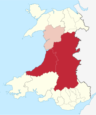
Powys is a county and preserved county in Wales. It borders Gwynedd, Denbighshire, and Wrexham to the north; the English ceremonial counties of Shropshire and Herefordshire to the east; Monmouthshire, Blaenau Gwent, Merthyr Tydfil, Caerphilly, Rhondda Cynon Taf, and Neath Port Talbot to the south; and Carmarthenshire and Ceredigion to the west. The largest settlement is Newtown, and the administrative centre is Llandrindod Wells.

Brecknockshire, also known as the County of Brecknock, Breconshire, or the County of Brecon, was one of the thirteen historic counties of Wales. It was created in 1536 under the Laws in Wales Act 1535. From 1889 it was an administrative county with a county council; the administrative county was abolished in 1974. The county was named after the medieval Welsh territory of Brycheiniog, which was anglicised to "Brecknock" and also gave its name to the county town of Brecon. The county was mountainous and primarily rural.

Radnorshire was one of the thirteen historic counties of Wales and later from 1974 to 1996 a district. It covered a sparsely populated area, and was bounded to the north by Montgomeryshire and Shropshire, to the east by Herefordshire, to the south by Brecknockshire and to the west by Cardiganshire.

The Elan Valley Reservoirs are a chain of man-made lakes created from damming the Elan and Claerwen rivers within the Elan Valley in Mid Wales. The reservoirs, which were built by the Birmingham Corporation Water Department, provide clean drinking water for Birmingham in the West Midlands of England. The five lakes are known as the Claerwen, Craig-goch, Pen-y-garreg, Garreg-ddu, and Caban-coch.

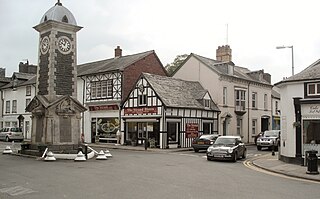
Rhayader is a market town and community in Powys, Wales, within the historic county of Radnorshire. The town is 20 miles (32 km) from the source of the River Wye on Plynlimon, the highest point of the Cambrian Mountains, and is located at the junction of the A470 road and the A44 road 13 miles (21 km) north of Builth Wells and 30 miles (48 km) east of Aberystwyth.

Builth Wells is a market town and community in the county of Powys and historic county of Brecknockshire (Breconshire), mid Wales, lying at the confluence of rivers Wye and Irfon, in the Welsh part of the Wye Valley. In 2011 it had a population of 2,568.

Mid Wales, or Central Wales, is a region of Wales, encompassing its midlands, in-between North Wales and South Wales. The Mid Wales Regional Committee of the Senedd covered the unitary authority areas of Ceredigion and Powys and the area of Gwynedd that had previously been the district of Meirionnydd. A similar definition is used by the BBC. The Wales Spatial Plan defines a region known as "Central Wales" which covers Ceredigion and Powys.

Llanelwedd is a village and community near Builth Wells, in Powys, Wales. It lies within the historic boundaries of Radnorshire. Llanelwedd features the Royal Welsh Showground.
The Central Wales Football League(formerly the Mid Wales Football League) is a football league in Wales at tier four of the Welsh Football pyramid, run by the Central Wales Football Association. The league consists of two regionally based divisions - a Northern Division and a Southern Division. The league offers a promotion route to the Football Association of Wales administered tier three Ardal Leagues. Relegation is possible to the relevant tier five level leagues in Aberystwyth, Ceredigion and Montgomeryshire.
The office of High Sheriff of Powys was established in 1974 as part of the creation of the county of Powys in Wales, replacing the shrievalties of the amalgamated counties: High Sheriff of Montgomeryshire, High Sheriff of Radnorshire and High Sheriff of Brecknockshire.

The Mid-Wales Railway was conceived as a trunk route through Wales connecting industrial areas in North West England with sea ports in South West Wales. The company was prevented from reaching its goal by competing proposals in Parliament, and it was only able to build a line between Llanidloes and a junction with the Brecon and Merthyr Railway 5 miles (8 km) east of Brecon. The line was 70 miles (110 km) long and opened in 1864. The company found it impossible to raise the share subscription, but the contractor partnership of Davies and Savin agreed to build the line and take shares in payment,
The Mid Wales South League was an association football league, from Mid Wales but some from just over the border in England. It was last called the Watson Financial Mid Wales League (South) for sponsorship reasons.
Lôn Cambria is the section in Wales of National Cycle Route 81 in the British National Cycle Network, which runs from Aberystwyth to Wolverhampton.

Afon Elan is a tributary of the River Wye which runs through the wide expanse of upland moors, traditionally known as Elenydd, in central Wales. Its valley is the Elan Valley. The name probably arises from elain meaning 'hind' or 'fawn' in reference perhaps to the rushing, bounding nature of its course.

Llanbister is a small village and community with a 2011 population of 382 in Powys, mid Wales, in the historic county of Radnorshire. It is on the river Ithon, at the junction of the A483 road and the B4356. It is served by Llanbister Road railway station on the Heart of Wales Line, but the station is some 4 miles east of the village.
The Radnorshire Challenge Cup is a football knockout tournament competed for by clubs either based within the Mid-Wales county boundary of Radnorshire or have a team in membership of the Mid Wales South League.


