Listed buildings in Conisbrough and Denaby

Last updated

Conisbrough is a ward and Denaby is a civil parish in the metropolitan borough of Doncaster, South Yorkshire, England. The ward and parish contain 18 listed buildings that are recorded in the National Heritage List for England. Of these, two are listed at Grade I, the highest of the three grades, and the others are at Grade II, the lowest grade. The listed buildings are in the town of Conisbrough, and the villages of Denaby Main and Old Denaby. The most important buildings are Conisbrough Castle and St Peter's Church, both listed at Grade I. The other listed buildings include houses, a medieval well cover, a set of stocks, a public house, a railway station and station house, a railway viaduct, two mileposts, another church and a chapel, a drinking fountain, and two war memorials.

Contents

Key

Map all coordinates using: OpenStreetMap
GradeCriteria [1]
IParticularly important buildings of more than special interest
IIBuildings of national importance and special interest

Buildings

Name and locationPhotographDateNotesGrade
St Peter's Church
53°28′59″N1°13′47″W / 53.48305°N 1.22967°W / 53.48305; -1.22967 (St Peter's Church)
St.Peter's church - geograph.org.uk - 922213.jpg
8th century (probable)The church was altered and extended through the centuries, it was restored in 1866–67, and the vestry was added in 1913–14. It is built in magnesian limestone with lead roofs, and consists of a nave with a clerestory, north and south aisles, a south porch, a chancel with a north chapel and vestry, and a west tower embraced by the aisles. The tower has angle buttresses, a west doorway with a pointed arch, a statue niche, and clock faces on the north and south sides. At the top is a string course with north and south gargoyles, a traceried frieze, and an embattled parapet with crocketed pinnacles. There are embattled parapets on the nave, aisles and porch. [2] [3] I
Conisbrough Castle
53°29′04″N1°13′33″W / 53.48442°N 1.22580°W / 53.48442; -1.22580 (Conisbrough Castle)
ConisbroughCastle.jpg
c. 1120The remains of the castle are in magnesian limestone. They consist of the keep, and a D-shaped enclosure with the remains of the gatehouse and a barbican. The keep is cylindrical, about 28 metres (92 ft) high, with four storeys, and six full-height buttresses rising as turrets. The third floor contains a chapel with a small vestry. [4] [5] I
Well cover
53°29′01″N1°13′49″W / 53.48354°N 1.23027°W / 53.48354; -1.23027 (Well cover)
Late medievalThe well cover is in limestone, and is partly buried in the pavement. It has a rectangular plan, and a pitched roof with projecting verges and a moulded ridge. In the south end is a blocked entrance. [6] II
The Old Hall, Denaby
53°29′10″N1°16′24″W / 53.48615°N 1.27345°W / 53.48615; -1.27345 (The Old Hall, Denaby)
15th centuryA medieval house, much altered and divided, it is in sandstone with some brick, partly rendered, with quoins, and tile roofs. There are two stoeys and a partilal cellar, the windows are casements, and on the north front is a garderobe turret. [7] [8] II
Former Old Hall Restaurant
53°28′57″N1°13′50″W / 53.48240°N 1.23051°W / 53.48240; -1.23051 (Former Old Hall Restaurant)
Cromwell's, Conisbrough.jpg
Early to mid 18th centuryA house later used for other purposes, it is in magnesian limestone, with rusticated quoins, stone slate eaves courses, and a pantile roof with coped gables and shaped kneelers. There are two storeys, cellars and attics, five bays, and lean-tos on the left and rear. The doorway has an architrave, a frieze with urns and a swag, and a cornice, and the windows are sashes. [9] II
Set of stocks
53°29′00″N1°13′34″W / 53.48329°N 1.22601°W / 53.48329; -1.22601 (Set of stocks)
Conisbrough stocks - geograph.org.uk - 631369.jpg
Late 18th century (probable)The stocks were resited in Coronation Park in the early 20th century. They consist of a pair of square magnesian limestone posts with rounded tops. The boards are wooden, and contain four holes for legs. [10] II
The Old Priory Nursing Home and outbuilding
53°29′04″N1°13′42″W / 53.48431°N 1.22827°W / 53.48431; -1.22827 (The Old Priory Nursing Home and outbuilding)
c. 1800A vicarage that was later extended and used for other purposes, it is in magnesian limestone with a hipped roof of Welsh slate and pantile. There are two storeys, a front of four bays, and a rear wing continuing as an outbuilding. The middle two bays project under a coped pedimented gable with a blind quatrefoil in the tympanum. In the right bay is a canted bay window, and the other windows are sashes. [11] II
The Red Lion public house
53°28′45″N1°13′42″W / 53.47903°N 1.22845°W / 53.47903; -1.22845 (The Red Lion public house)
The Red Lion, Conisbrough - geograph.org.uk - 2708470.jpg
Late 18th to early 19th centuryThe public house is pebbledashed, and has a roof of Welsh slate and stone slate. There are three storeys, a central block of three bays with a pedimented gable, and lean-to side wings, each with a half-pediment. The central doorway has an architrave, a fanlight, and a cornice. It is flanked by canted bay windows, and the other windows are sashes, those in the wings in round-arched recesses. [12] [13] II
The Priory
53°28′59″N1°13′43″W / 53.48300°N 1.22852°W / 53.48300; -1.22852 (The Priory)
Early to mid 19th centuryA house later used for other purposes, it is stuccoed, with giant end pilasters, a cornice below a parapet containing balustraded panels, and a hipped Welsh slate roof. There are two storeys, three bays, the middle bay projecting, and a rear wing projecting to the right. Steps lead up to a central doorway that has an archivolt with a keystone, and a modillion cornice. In the outer bays are canted bay windows with modillion cornices, and the other windows are sashes, the window above the doorway in a segmental-arched recess. [14] II
Mexborough station and station house
53°29′27″N1°17′19″W / 53.49096°N 1.28858°W
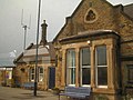
 / 53.49096; -1.28858 (Mexborough station and station house)
Mexborough railway station 1.jpg
1871The station and house were built by the Manchester, Sheffield and Lincolnshire Railway. They are in sandstone with a Welsh slate roof, and consist of a single-storey range containing a parcel office, a ticket office and waiting rooms, and at the east end is a two-storey house. The buildings have a chamfered plinth, quoins, chamfered surrounds to sash windows, an eaves band, and an arcaded loggia. The house and the ticket office each has a bay window, and above is a gable containing a quatrefoil. On the ticket office is a war memorial plaque, and to the right of it is a pedestrian entrance. [15] [16] II
Milepost, Conisbrough
53°29′21″N1°14′05″W / 53.48926°N 1.23480°W / 53.48926; -1.23480 (Milepost, Conisbroughain)
Milepost, Conisbrough.jpg
Late 19th centuryThe milepost is on the south side of Doncaster Road, and is in stone with cast iron overlay. It has a triangular plan and a rounded top. On the top is inscribed "BRAMPTON BIERLOW & HOOTON" "ROBERTS ROAD" "SWINTON BRANCH" and "CONISBORO", and on the sides are the distances to Doncaster, Conisbrough, Barnsley, Wentworth, Swinton, and Mexborough. [17] II
Milepost, Denaby Main
53°29′35″N1°15′28″W / 53.49294°N 1.25781°W / 53.49294; -1.25781 (Milepost, Denaby Main)
Milepost, Denaby Main.jpg
Late 19th centuryThe milepost is on the north side of Doncaster Road, and is in stone with cast iron overlay. It has a triangular plan and a rounded top. On the top is inscribed "BRAMPTON BIERLOW & HOOTON" "ROBERTS ROAD" "SWINTON BRANCH" and "DENABY", and on the sides are the distances to Doncaster, Conisbrough, Barnsley, Wentworth, Swinton, and Mexborough. [18] II
Wesleyan Methodist Chapel
53°28′51″N1°13′44″W / 53.48078°N 1.22896°W / 53.48078; -1.22896 (Wesleyan Methodist Chapel)
Wesleyan Methodist Chapel. Conisbrough.jpg
1876The chapel is in orange brick with sandstone dressings and a hipped tile roof, and is in Italianate style. The front has two storeys and three bays, the middle bay projecting under a broken triangular pediment, with bands, and pilasters flanking the middle bay and at the corner. In the centre are double round-headed doorways, over which is an inscribed and dated plaque. The upper floor contains a tripartite window with round-headed lights, and above is a semicircular window. The outer bays also contain round-headed windows, and all the openings have keystones. [19] II
St Alban's Church and presbytery
53°29′22″N1°14′40″W / 53.48951°N 1.24450°W / 53.48951; -1.24450 (St Alban's Church and presbytery)
Church on Wadworth Street - geograph.org.uk - 2583247.jpg
1897–98The north aisle and chapel were added to the church in 1920. It is built in sandstone with Welsh slate roofs, and consists of a nave and chancel in one unit with a clerestory, a south aisle, a north aisle between gabled projections, and a southwest tower. The tower has corner gargoyles, a coped parapet, and a shingled octagonal spirelet with a heart-shaped finial. A link from the south aisle leads to the presbytery, which is at right angles. The presbytery has two storeys and an attic, and coped gables. Some windows are sashes, and others are mullioned and transomed. [20] [21] II
Conisbrough Viaduct
53°29′20″N1°12′42″W / 53.48877°N 1.21167°W
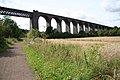
 / 53.48877; -1.21167 (Conisbrough Viaduct)
Conisbrough Viaduct - geograph.org.uk - 925574.jpg
1906–07The viaduct was built by the Dearne Valley Railway to carry its line over the valley of the River Don, and is 482.8 metres (1,584 ft) long. It is in red brick, faced by Staffordshire blue engineering brick, and crossing the river is a lattice girder span, There are 21 round arches, with tapering piers, impost bands, and hood moulds. The parapets are carried on corbel tables and have flat coping stones. [12] [22] II
Drinking fountain and lamp
53°28′58″N1°13′34″W / 53.48287°N 1.22614°W / 53.48287; -1.22614 (Drinking fountain and lamp)
Cast iron fountain and lamp standard. - geograph.org.uk - 523256.jpg
1911The drinking fountain and lamp standard are by the southern entrance to Coronation Park, and in cast iron. The base is shaped and octagonal, and contains a narrow dog trough. The main basin is D-shaped with a rounded lip, and in the centre is an octagonal column with a round-arched panel on each face, the front face inscribed and dated. The top of the column is ogee-shaped with fleur-de-lys motifs, and is surmounted by a lamp standard with decorative shell motifs and a ladder bar. [23] II
Conisbrough War Memorial
53°28′59″N1°13′34″W / 53.48312°N 1.22600°W / 53.48312; -1.22600 (Conisbrough War Memorial)
Conisbrough war memorial (9438).jpg
c. 1920The war memorial is in sandstone, and consists of the life-size statue of an infantryman with a rifle standing on a stylised square Doric column. The column is on a plinth of three steps, there is an inscription on the base, and on the faces of the column are bronze plaques with the names of those lost in the First World War. [12] [24] II
Denaby War Memorial
53°29′32″N1°14′52″W / 53.49230°N 1.24783°W / 53.49230; -1.24783 (Denaby War Memorial)
The Denaby War Memorial (geograph 2954608).jpg
1930sThe war memorial is in Memorial Park, and it consists of a square sandstone column with a stepped cap surmounted by a stylised lamp. This stands on a square plinth on a platform of three octagonal steps. The faces of the column are incised with a Latin cross design, and on the faces are bronze plaques with inscriptions and the names of those lost in the two World Wars. [25] II

Related Research Articles

Ackworth is a civil parish in the metropolitan borough of the City of Wakefield, West Yorkshire, England. The parish contains 36 listed buildings that are recorded in the National Heritage List for England. Of these, one is listed at Grade I, the highest of the three grades, four are at Grade II*, the middle grade, and the others are at Grade II, the lowest grade. The parish contains the settlements of High Ackworth, Low Ackworth, Ackworth Moor Top, and part of East Hardwick, and the surrounding countryside. Most of the listed buildings are houses, cottages and associated structures. The other listed buildings include a church and items in the churchyard, a plague stone or cross base, a village cross, former almshouses, a school and an associated Quaker meeting house, three guide posts, and two mileposts,

Darrington is a civil parish in the metropolitan borough of the City of Wakefield, West Yorkshire, England. The parish contains 16 listed buildings that are recorded in the National Heritage List for England. Of these, one is listed at Grade I, the highest of the three grades, and the others are at Grade II, the lowest grade. The parish contains the villages of Darrington and Wentbridge and the surrounding countryside. The listed buildings consist of houses and associated structures, two churches and items in the churchyard of the older church, a farmhouse, farm buildings, a former windmill, a former school, a bridge and a viaduct, a guide post, and a milestone.

Hemsworth is a civil parish in the metropolitan borough of the City of Wakefield, West Yorkshire, England. The parish contains eleven listed buildings that are recorded in the National Heritage List for England. All the listed buildings are designated at Grade II, the lowest of the three grades, which is applied to "buildings of national importance and special interest". The parish contains the town of Hemsworth, the village of Fitzwilliam, and the surrounding countryside. Most of the listed buildings are houses and associated structures, and the others consist of a church, a public house, and three mileposts.

Brierley is a town and Grimethorpe is a village in the North East Ward in the metropolitan borough of Barnsley, South Yorkshire, England. The ward contains six listed buildings that are recorded in the National Heritage List for England. Of these, one is listed at Grade II*, the middle of the three grades, and the others are at Grade II, the lowest grade. The listed buildings consist of three houses, a farmhouse, a milepost, and a church.

Rockingham is a ward in the metropolitan borough of Barnsley, South Yorkshire, England. The ward contains seven listed buildings that are recorded in the National Heritage List for England. All the listed buildings are designated at Grade II, the lowest of the three grades, which is applied to "buildings of national importance and special interest". The ward contains the village of Birdwell, part of the town of Hoyland, and the surrounding area. The listed buildings consist of a farmhouse and farm buildings, some of which have been converted for residential use, a church, a milepost, a memorial obelisk, and a ruined prospect tower.

Balby South is a ward in the metropolitan borough of Doncaster, South Yorkshire, England. The ward contains three listed buildings that are recorded in the National Heritage List for England. All the listed buildings are designated at Grade II, the lowest of the three grades, which is applied to "buildings of national importance and special interest". The ward contains part of the suburb of Balby and part of the village of Warmsworth. The listed buildings in the ward consist of a church, and a large house, later a hospital and then offices, and associated structures.

Bawtry is a civil parish in the metropolitan borough of Doncaster, South Yorkshire, England. The parish contains 44 listed buildings that are recorded in the National Heritage List for England. Of these, one is listed at Grade I, the highest of the three grades, one is at Grade II*, the middle grade, and the others are at Grade II, the lowest grade. The parish contains the town of Bawtry and the surrounding area. Most of the listed buildings are in or near the town centre, and include houses and associated structures, shops, offices, churches, a headstone in a churchyard, a market cross, a hotel, a restaurant, public houses, a pinfold, a Masonic Hall and gate, and a war memorial. Outside the town are a listed milepost and a bridge.

Bentley is a ward in the metropolitan borough of Doncaster, South Yorkshire, England. The ward contains 22 listed buildings that are recorded in the National Heritage List for England. Of these, one is listed at Grade I, the highest of the three grades, and the others are at Grade II, the lowest grade. The ward contains the suburb of Bentley, the villages of Almholme, Arksey, and Toll Bar, and the surrounding area. There is a group of listed buildings in Arksey, including the church, the vicarage, the former school and its wall, a group of almshouses, a hall, and a pinfold. Elsewhere, the listed buildings include another church, another pinfold, houses and cottages, a former watermill, farmhouses and farm buildings, a road causeway, a road bridge, and four mileposts.

Brodsworth is a civil parish in the metropolitan borough of Doncaster, South Yorkshire, England. The parish contains 24 listed buildings that are recorded in the National Heritage List for England. Of these, one is listed at Grade I, the highest of the three grades, one is at Grade II*, the middle grade, and the others are at Grade II, the lowest grade. The parish contains the village of Brodsworth and the surrounding area. The most important building in the parish is Brodsworth Hall, which is listed, together with associated structures and items in the gardens and grounds. The other listed buildings include houses, cottages and associated structures, farmhouses and farm buildings, a church, a milepost, and a school.

Cadeby is a civil parish in the metropolitan borough of Doncaster, South Yorkshire, England. The parish contains five listed buildings that are recorded in the National Heritage List for England. All the listed buildings are designated at Grade II, the lowest of the three grades, which is applied to "buildings of national importance and special interest". The parish contains the village of Cadeby and the surrounding countryside. The listed buildings consist of a farmhouse, a barn, a church, and the two portals of Conisbrough Railway Tunnel.

Edlington is a civil parish in the metropolitan borough of Doncaster, South Yorkshire, England. The parish contains five listed buildings that are recorded in the National Heritage List for England. Of these, one is listed at Grade I, the highest of the three grades, and the others are at Grade II, the lowest grade. The parish contains the town of Edlington and the surrounding area. The listed buildings consist of a church, a dovecote, a monument to the memory of a dog, a farmhouse, and a war memorial.

Hatfield is a civil parish in the metropolitan borough of Doncaster, South Yorkshire, England. The parish contains 32 listed buildings that are recorded in the National Heritage List for England. Of these, two are listed at Grade I, the highest of the three grades, and the others are at Grade II, the lowest grade. The parish contains the villages of Hatfield and Hatfield Woodhouse, and the surrounding area. Most of the listed buildings are houses, cottages and associated structures, farmhouses and farm buildings. The other listed buildings include churches and associated items, a former charity school, two former tower windmills, three mileposts, and a cemetery chapel.

High Melton is a civil parish in the metropolitan borough of Doncaster, South Yorkshire, England. The parish contains eight listed buildings that are recorded in the National Heritage List for England. Of these, one is listed at Grade II*, the middle of the three grades, and the others are at Grade II, the lowest grade. The parish contains the village of High Melton and the surrounding area. All the listed buildings are in the village, and consist of a church, a country house later used for other purposes, houses, cottages, farmhouses, a former village hall, and a milestone.

Mexborough is a town and a ward in the metropolitan borough of Doncaster, South Yorkshire, England. The ward contains two listed buildings that are recorded in the National Heritage List for England. Of these, one is listed at Grade I, the highest of the three grades, and the other is at Grade II, the lowest grade. The listed buildings consist of a church and a free-standing carved arch.

Norton is a civil parish, and Norton and Askern is a ward, in the metropolitan borough of Doncaster, South Yorkshire, England. The parish and ward contain 27 listed buildings that are recorded in the National Heritage List for England. Of these, two are listed at Grade I, the highest of the three grades, and the others are at Grade II, the lowest grade. The parish and ward contain the villages of Norton, Campsall, Skellow, and Sutton and the surrounding countryside. Most of the listed buildings are houses, cottages and associated structures, farmhouses and farm buildings. The other listed buildings include a church, three cross bases, two bridges, a former windmill, a former watermill, a public house, two mileposts, a former toll house, and a village pump.

Rossington is a civil parish in the metropolitan borough of Doncaster, South Yorkshire, England. The parish contains ten listed buildings that are recorded in the National Heritage List for England. Of these, one is listed at Grade II*, the middle of the three grades, and the others are at Grade II, the lowest grade. The parish contains the village of Rossington and the surrounding area. The listed buildings include houses and associated structures, two churches, a milepost, a shop, a well house, and a war memorial.

Town ward is a ward in the metropolitan borough of Doncaster, South Yorkshire, England. The ward contains 105 listed buildings that are recorded in the National Heritage List for England. Of these, two are listed at Grade I, the highest of the three grades, two are at Grade II*, the middle grade, and the others are at Grade II, the lowest grade. The ward contains the central part of the town of Doncaster. Most of the listed buildings in the ward are houses and associated structures, shops, offices, hotels and public houses, commercial buildings, market buildings, and public buildings. The town has an important railway history, and buildings associated with this, including some in Doncaster Works and Doncaster railway station are listed. The other listed buildings include a lock on the River Don Navigation, churches and associated structures, a former theatre, a war memorial, and a former swimming pool and health club.

Boston Castle is a ward in the Metropolitan Borough of Rotherham, South Yorkshire, England. The ward contains 39 listed buildings that are recorded in the National Heritage List for England. Of these, three are listed at Grade I, the highest of the three grades, three are at Grade II*, the middle grade, and the others are at Grade II, the lowest grade. The ward contains the central part of the town of Rotherham and the area of Moorgate to the south. The listed buildings include houses and associated structures, churches and a chapel, shop and offices, re-sited Roman remains, a former shooting lodge in the form of a castle, schools, a lamp standard for an oil lamp, a former foundry, mileposts, a public house, a commemorative clock, two war memorials, and a former cinema.

Keppel is a ward in the Metropolitan Borough of Rotherham, South Yorkshire, England. The ward contains 13 listed buildings that are recorded in the National Heritage List for England. Of these, one is listed at Grade II*, the middle of the three grades, and the others are at Grade II, the lowest grade. The ward contains the suburb of Kimberworth to the north of the centre of Rotherham, the village of Thorpe Hesley further to the north, and the surrounding area. The listed buildings consist of houses and associated structures, farmhouses and farm buildings, churches, a commemorative column, a milepost, and a war memorial.

Rotherham East is a ward in the Metropolitan Borough of Rotherham, South Yorkshire, England. The ward contains three listed buildings that are recorded in the National Heritage List for England. All the listed buildings are designated at Grade II, the lowest of the three grades, which is applied to "buildings of national importance and special interest". The ward is to the east of the centre of Rotherham, and the listed buildings consist of a set of gate piers and walls, a milepost, and a church.

References

Citations

Sources