Related Research Articles

The Stikine River is a river, historically also the Stickeen River, approximately 610 kilometres (380 mi) long, in northwestern British Columbia in Canada and in southeast Alaska in the United States.

Dease Lake is a small community located in the Cassiar Country of the Northern Interior of British Columbia, Canada. It is located a few hours south of the Yukon border on Stewart–Cassiar Highway at the south end of the lake of the same name. Dease Lake is the last major centre before the Alaska Highway while driving north bound, and also the junction to Telegraph Creek and the Grand Canyon of the Stikine. Dease Lake Indian Reserve No. 9 is located nearby and is under the governance of the Tahltan First Nation band government.
The Stikine Ranges are a group of mountain ranges and mountainous plateaus in northwestern British Columbia, Canada. They are the northernmost subdivision of the Cassiar Mountains and among the least explored and most undeveloped parts of the province.

The Tuya Range is a mountain range in the Stikine Ranges of the Cassiar Mountains in the far north of the Canadian province of British Columbia, near its border with the Yukon Territory and to the southwest of Watson Lake, Yukon, which is the nearest major settlement.
Toozaza Peak is a tuya in the Stikine Ranges of the Cassiar Mountains in northern British Columbia, Canada, located in the Iverson Creek. Toozaza Peak is the summit of a north–south aligned ridge between the head of Toozaza Creek and the head of the Jennings River, just south of the Jennings' divide with the Little Rancheria River headwaters. The Little Rancheria and Toozaza Creek are part of the Liard, while the Jennings is part of the Yukon River drainage via Teslin Lake, and the peak therefore stands astride the line of the Continental Divide. It is part of the Tuya Volcanic Field, a volcanic field associated with the Stikine Volcanic Belt, part of the Northern Cordilleran Volcanic Province.
The Beaver River is a tributary of the Liard River, entering that stream in the area of its Grand Canyon just south of the British Columbia-Yukon border after running generally south-east from its origin in the extreme southeast corner of the Yukon Territory.

The Tahltan River is a tributary of the Stikine River in northwest part of the province of British Columbia, Canada. It flows generally east and southeast about 95 km (59 mi) to join the Stikine River at Tahltan, British Columbia.
The Swift River is a river that begins in Yukon Territory and flows southwest into British Columbia to its mouth at the east side of Teslin Lake on the Teslin River system. The river drains the uppermost portion of the Cassiar Mountains and in its lower reaches traverses the Nisutlin Plateau, which lies along the east side of Teslin Lake north of the mouth of the Jennings River, which is to the south of the Swift.
The Rancheria River is a tributary of the Liard River in the southern Yukon Territory, Canada, just north of the border with British Columbia. The river's main tributary is the Little Rancheria River, which begins in British Columbia. Both river basins are in the northernmost of extension of the Stikine Ranges of the Cassiar Mountains, which extend from the Finlay River north to the Liard and end just inside the Yukon, with the Rancheria River forming the northern end of the range.
The Jennings River is a river in far northern British Columbia, Canada. It is approximately 150 kilometres (93 mi) long. The river was named for William T. Jennings (1846-1906), a civil engineer who, in 1897, assessed various road and railroad routes from the Pacific Ocean to the Yukon.
The Cottonwood River is a tributary of the Dease River in the Cassiar Country of the Northern Interior of British Columbia, Canada. Rising in the northern Stikine Ranges just east of Toozaza Peak, and just south of the origins of the Jennings and Little Rancheria River near the border with Yukon, it flows south along the east flank of the Tuya Range to meet the Dease just north of that river's source at Dease Lake, between the north end of that lake and McDame Creek and the former mining centre and community of McDame Post.
The Tuya River is a major tributary of the Stikine River in far northwestern British Columbia, Canada. Rising at Tuya Lake, which is on the south side of Tuya Mountains Provincial Park, it flows south to meet the Stikine River where that river bisects the Tahltan Highland. Its main tributary is the Little Tuya River.
The Klappan River is a major tributary of the Stikine River in northwestern British Columbia, Canada. It flows north from an area known as the Sacred Headwaters, which is the source not only of this river but also of the Nass, Skeena, Spatsizi and Stikine Rivers. The headwaters region is the site of a controversial coal-bed methane project.
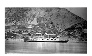
Steamboats operated on the Stikine River in response to gold finds in along that river and in the Cassiar Country of northwestern British Columbia, Canada.
The Cassiar Land District is a cadastral survey subdivision of the province of British Columbia, Canada, created with rest of those on Mainland British Columbia via the Lands Act of the Colony of British Columbia in 1860. The British Columbia government's BC Names system, a subdivision of GeoBC, defines a land district as "a territorial division with legally defined boundaries for administrative purposes" All land titles and surveys use the Land District system as the primary point of reference, and entries in BC Names for placenames and geographical objects are so listed.
The Tasakili River is a tributary of the Stikine River, flowing southeast out of the Boundary Ranges on the United States side of the range to join that river in Canada, just before the Stikine transits the Alaska-British Columbia border.
Cornice Mountain, 1503 m, is a mountain in the Stikine Icecap area of the Boundary Ranges in northwestern British Columbia, Canada. It is located southwest of the confluence of the Flood and Stikine Rivers.
Cornice Mountain, 2339 m, is a mountain in the Cambria Icefield of the Boundary Ranges of the northern Coast Mountains in British Columbia, Canada. The peak is on the north flank of the Cambria Icefield, south of Strohn Creek and between Meziadin Lake and the Bear River Pass, northeast of the town of Stewart.
The Quaal River is a river in the Kitimat Ranges of the Coast Mountains in British Columbia, Canada, flowing south into Kitkiata Inlet in the North Coast region.
Beatty Creek is a tributary of the Tahltan River in northwest part of the province of British Columbia, Canada. It flows generally south about 62 km (39 mi) to join the Tahltan River a few kilometres downstream from the Little Tahltan River confluence. The Tahltan River is one of the main tributaries of the Stikine River.
References
- Canada GeoNames Database entry (YT)
- Canada GeoNames Database entry (BC)
- "Stikine Ranges". BC Geographical Names.
Coordinates: 60°12′13″N129°33′36″W / 60.20361°N 129.56000°W