Logan Township, Fountain County, Indiana

Last updated
Logan Township
Map highlighting Logan Township, Fountain County, Indiana.svg
Location of Logan Township in Fountain County
Coordinates: 40°17′15″N87°12′39″W / 40.28750°N 87.21083°W / 40.28750; -87.21083 Coordinates: 40°17′15″N87°12′39″W / 40.28750°N 87.21083°W / 40.28750; -87.21083
Country United States
State Indiana
County Fountain
Government
  Type Indiana township
Area
  Total22.62 sq mi (58.6 km2)
  Land22.23 sq mi (57.6 km2)
  Water0.38 sq mi (1.0 km2)
Elevation
[1]
679 ft (207 m)
Population
 (2010)
  Total3,672
  Density165.2/sq mi (63.8/km2)
FIPS code 18-44622 [2]
GNIS feature ID453579

Logan Township is one of eleven townships in Fountain County, Indiana, United States. As of the 2010 census, its population was 3,672 and it contained 1,685 housing units. [3]

Contents

History

The Bethel Church and Graveyard was listed on the National Register of Historic Places in 1995. [4]

Geography

According to the 2010 census, the township has a total area of 22.62 square miles (58.6 km2), of which 22.23 square miles (57.6 km2) (or 98.28%) is land and 0.38 square miles (0.98 km2) (or 1.68%) is water. [3] It contains the town of Attica, which is near the banks of the Wabash River and which has a population of about 3,200 people.

U.S. Route 41, [5] Indiana State Road 28 [6] and Indiana State Road 55 [7] enter the township from Warren County, across the river to the west; at this point they all share the same route. In passing through Attica, U.S. 41 and State Road 55 go south, while State Road 28 continues east. A Norfolk Southern Railway line also crosses the river into the township; the line continues east-northeast near the river, [8] carrying about 45 freight trains each day. [9]

Map of Logan Township Map of Logan Township, Fountain County, Indiana.svg
Map of Logan Township

Cemeteries

The township contains five cemeteries. Riverside and Saint Francis of Xavier are on the south edge of Attica, [10] [11] while Hatton is on the southeast side of town. [12] Ruppert lies further to the southeast outside of town, [13] and Clark is in the far northeast corner of the township. [14]

Related Research Articles

Adams Township, Warren County, Indiana Township in Indiana, United States

Adams Township is one of twelve townships in Warren County, Indiana. According to the 2010 census, its population was 512 and it contained 250 housing units.

Jordan Township, Warren County, Indiana Township in Indiana, United States

Jordan Township is one of twelve townships in Warren County, Indiana, United States. According to the 2010 census, its population was 247 and it contained 105 housing units. It is almost entirely agricultural and contains no incorporated towns.

Kent Township, Warren County, Indiana Township in Indiana, United States

Kent Township is one of twelve townships in Warren County, Indiana, United States. According to the 2010 census, its population was 428 and it contained 196 housing units.

Liberty Township, Warren County, Indiana Township in Indiana, United States

Liberty Township is one of twelve townships in Warren County, Indiana, United States. According to the 2010 census, its population was 896 and it contained 362 housing units.

Medina Township, Warren County, Indiana Township in Indiana, United States

Medina Township is one of twelve townships in Warren County, Indiana, United States. According to the 2010 census, its population was 457 and it contained 191 housing units.

Mound Township, Warren County, Indiana Township in Indiana, United States

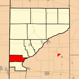
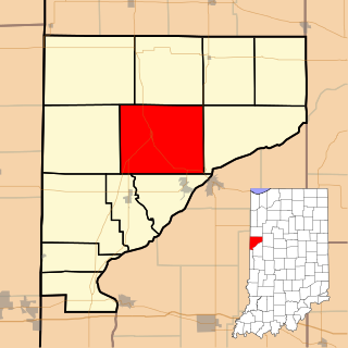
Mound Township is one of twelve townships in Warren County, Indiana, United States. According to the 2010 census, its population was 418 and it contained 183 housing units.

Pike Township, Warren County, Indiana Township in Indiana, United States

Pike Township is one of twelve townships in Warren County, Indiana, United States. According to the 2010 census, its population was 1,221 and it contained 529 housing units.

Pine Township, Warren County, Indiana Township in Indiana, United States

Pine Township is one of twelve townships in Warren County, Indiana, United States. According to the 2010 census, its population was 481 and it contained 213 housing units.

Prairie Township, Warren County, Indiana Township in Indiana, United States

Prairie Township is one of twelve townships in Warren County, Indiana, United States. According to the 2010 census, its population was 257 and it contained 117 housing units; the population density is the lowest of any township in the county, at 6.1 inhabitants per square mile (2.4/km2).

Steuben Township, Warren County, Indiana Township in Indiana, United States

Steuben Township is one of twelve townships in Warren County, Indiana, United States. It was established in 1834. According to the 2010 census, its population was 487 and it contained 199 housing units. It contains no incorporated towns and is largely agricultural.

Warren Township, Warren County, Indiana Township in Indiana, United States

Warren Township is one of twelve townships in Warren County, Indiana, United States. According to the 2010 census, its population was 806 and it contained 324 housing units.

Washington Township, Warren County, Indiana Township in Indiana, United States

Washington Township is one of twelve townships in Warren County, Indiana, United States. It is the most populous township in the county; according to the 2010 census, its population was 2,298, with 1,898 of those living in Williamsport, and it contained 1,011 housing units. It has the highest population density of the Warren County townships at about 120 inhabitants per square mile (46/km2).

Bolivar Township, Benton County, Indiana Township in Indiana, United States

Bolivar Township is one of eleven townships in Benton County, Indiana. As of the 2010 census, its population was 1,252 and it contained 548 housing units. Bolivar Township was organized in March 1860 and named for South American liberator Simón Bolivar.

Hickory Grove Township, Benton County, Indiana Township in Indiana, United States

Hickory Grove Township is one of eleven townships in Benton County, Indiana. As of the 2010 census, its population was 409 and it contained 172 housing units. It was organized in March 1876 and named for a grove of hickory trees that grew within its borders in the 19th century.

Cain Township, Fountain County, Indiana Township in Indiana, United States

Cain Township is one of eleven townships in Fountain County, Indiana. As of the 2010 census, its population was 1,142 and it contained 488 housing units.

Davis Township, Fountain County, Indiana Township in Indiana, United States

Davis Township is one of eleven townships in Fountain County, Indiana, United States. As of the 2010 census, its population was 682 and it contained 286 housing units.

Fulton Township, Fountain County, Indiana Township in Indiana, United States

Fulton Township is one of eleven townships in Fountain County, Indiana, United States. As of the 2000 census, its population was 674.

Richland Township, Fountain County, Indiana Township in Indiana, United States

Richland Township is one of eleven townships in Fountain County, Indiana, United States. As of the 2010 census, its population was 950 and it contained 423 housing units.

Shawnee Township, Fountain County, Indiana Township in Indiana, United States

Shawnee Township is one of eleven townships in Fountain County, Indiana, United States. As of the 2010 census, its population was 672 and it contained 282 housing units.

Cleveland Township, Whitley County, Indiana Township in Indiana, United States

Cleveland Township is one of nine townships in Whitley County, Indiana, United States. As of the 2010 census, its population was 3,398 and it contained 1,441 housing units.

References

  1. "US Board on Geographic Names". United States Geological Survey. 2007-10-25. Retrieved 2008-01-31.
  2. "U.S. Census website". United States Census Bureau . Retrieved 2008-01-31.
  3. 1 2 "Population, Housing Units, Area, and Density: 2010 - County -- County Subdivision and Place -- 2010 Census Summary File 1". United States Census. Archived from the original on 2020-02-12. Retrieved 2013-05-10.
  4. "National Register Information System". National Register of Historic Places . National Park Service. July 9, 2010.
  5. "U.S. Route 41". Highway Explorer. Archived from the original on 2010-12-07. Retrieved 2010-09-21.
  6. "State Road 28". Highway Explorer. Archived from the original on 2011-07-11. Retrieved 2010-09-21.
  7. "State Road 55". Highway Explorer. Archived from the original on 2011-07-11. Retrieved 2010-09-21.
  8. "State of Indiana 2011 Rail System Map" (PDF). Indiana Department of Transportation. 2011. Retrieved 2011-06-19.
  9. Warren County Local Economic Development Organization. "Warren County Transportation/Utilities" . Retrieved 2010-09-12.
  10. "Riverside Cemetery". Geographic Names Information System . United States Geological Survey . Retrieved 2011-09-05.
  11. "Saint Francis of Xavier Cemetery". Geographic Names Information System . United States Geological Survey . Retrieved 2011-09-05.
  12. "Hatton Cemetery". Geographic Names Information System . United States Geological Survey . Retrieved 2011-09-05.
  13. "Ruppert Cemetery". Geographic Names Information System . United States Geological Survey . Retrieved 2011-09-05.
  14. "Clark Cemetery". Geographic Names Information System . United States Geological Survey . Retrieved 2011-09-05.