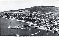
HobartHOH-bart; is the capital and most populous city of the island state of Tasmania, Australia. Located in Tasmania's south-east on the estuary of the River Derwent, it is the southernmost capital city in Australia. Despite containing nearly half of Tasmania's population, Hobart is the least-populated Australian state capital city, and second-smallest by population and area after Darwin if territories are taken into account. Its skyline is dominated by the 1,271-metre (4,170 ft) kunanyi / Mount Wellington, and its harbour forms the second-deepest natural port in the world, with much of the city's waterfront consisting of reclaimed land. The metropolitan area is often referred to as Greater Hobart, to differentiate it from the City of Hobart, one of the seven local government areas that cover the city. It has a mild maritime climate.

The River Derwent, also known as timtumili minanya in palawa kani, is a significant river and tidal estuary in Tasmania, Australia. It begins its journey as a freshwater river in the Central Highlands at Lake St Clair, descending over 700 metres (2,300 ft) across a distance of more than 200 kilometres (120 mi). At the settlement of New Norfolk in the Derwent Valley its waters become brackish, flowing through Hobart, the capital city of Tasmania, its seawater estuary eventually empties into Storm Bay and the Tasman Sea.

The Tasman Bridge is a prestressed concrete girder bridge connecting the Tasman Highway over the River Derwent in Hobart, Tasmania, Australia. When it opened on 29 March 1965, the Tasman was the longest prestressed concrete bridge in Australia, with a total length measuring 1,396 metres (4,580 ft), including approaches. The bridge provides a vital link between Hobart's city centre on the western shore and the City of Clarence on the eastern shore. Averaging 73,029 vehicle crossings per day, the bridge is the highest volume road section in Tasmania. It features five lanes of traffic including a central lane equipped for tidal flow operations and separated shared-use walkways on both sides, with ramp upgrades for improved access and cyclists completed in 2010.

Bruny Island is a 362-square-kilometre (140 sq mi) island located off the southeastern coast of Tasmania, Australia. The island is separated from the Tasmanian mainland by the D'Entrecasteaux Channel, and its east coast lies within the Tasman Sea. Located to the island's northeast Storm Bay, is the river mouth to the Derwent River estuary, and serves as the main port of Hobart, Tasmania's capital city. Both the island and the channel are named after French explorer, Antoine Bruni d'Entrecasteaux. Its traditional Aboriginal name is lunawanna-allonah, which survives as the name of two island settlements, Alonnah and Lunawanna.

Lake St Clair or leeawulenna is a natural freshwater lake located in the Central Highlands area of Tasmania, Australia. The lake forms the southern end of the Cradle Mountain-Lake St Clair National Park. It has an area of approximately 45 square kilometres (17 sq mi), and a maximum depth of 215 metres (705 ft), making it Australia's deepest lake.
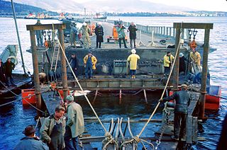
The Hobart Bridge was a floating arch bridge that crossed the River Derwent, connecting the eastern and western shores of the city of Hobart, Tasmania, Australia.

The Wrest Point Hotel Casino is a casino in Tasmania. It was Australia's first legal casino, opening in the suburb of Sandy Bay in Hobart, on 10 February 1973. The hotel tower is the tallest building in Hobart as well as Tasmania.

Sandy Bay is a prestigious suburb of the city of Hobart, Tasmania, Australia, located immediately south of the central business district and adjoining Battery Point. Sandy Bay is bordered by the Derwent River to the east and is known for its beaches, including Nutgrove Beach, Long Beach, and Lords Beach.

The Bowen Bridge is a segmental cantilever road bridge crossing the River Derwent in Tasmania, Australia. The bridge serves as a vital transportation link in the state capital of Hobart, facilitating the movement of vehicles, pedestrians, and cyclists between the local government areas of Clarence on the eastern shore and Glenorchy on the western shore. The Bowen Bridge links the East Derwent Highway with the Brooker Highway at Glenorchy, approximately 10 kilometres (6.2 mi) from the Hobart city centre.

Montagu Bay is a suburb of Hobart, Tasmania, located in the City of Clarence on the eastern shore of the Derwent River, about four kilometres from the city centre of greater Hobart. It is a small primarily residential suburb located between Rosny, Rose Bay and Lindisfarne and is centred on a small bay of the same name, formerly known as Smelting Works Bay. The bay has a boat ramp and jetty, and is frequently filled with yachts and other vessels at anchor.

Taroona is a major residential suburb approximately 15 minutes drive from the centre of Hobart, Tasmania on the scenic route between Hobart and Kingston. Although on the edges of the City of Hobart, Taroona is actually part of the municipality of Kingborough. Taroona is bounded on the east by the Derwent River, and has several beaches along the shore, the main beaches with public access are Taroona Beach, Hinsby Beach and Dixons Beach. Past Hinsby Beach, the Alum Cliffs form a section of cliffed coast to the neighbouring suburb of Bonnet Hill.
Bonnet Hill is a residential locality in the local government area (LGA) of Kingborough in the Hobart LGA region of Tasmania, Australia. The locality is about 2 kilometres (1.2 mi) east of the town of Kingston. The 2016 census recorded a population of 505 for the state suburb of Bonnet Hill.
Howrah Beach is a 1.2 km (1 mi) stretch of recreational beach situated along the River Derwent in Howrah, a suburb of Hobart, Tasmania, Australia. The south-facing beach neighbours Bellerive Beach to the west and is bookended by Howrah Point to the east. The beach has views of the Derwent estuary, the neighbouring suburb of Tranmere, Sandy Bay on the western shore, and southern views of South Arm, Tinderbox and the northern tip of Bruny Island. Howrah Beach is backed by a narrow tree-lined reserve and private properties, the Clarence Foreshore Trail, Clarence High School adjoining Wentworth Park, Howrah Community Centre, Howrah Men's Shed and the Sunshine Tennis Club.
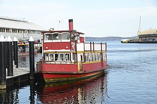
Ferries in Hobart are a form of public transport in the city of Hobart, Tasmania. Though for decades they had not provided a major alternative public transport service for commuters and tourists in Hobart across the Derwent River, a renewed ferry service began in 2021. This has resulted in a revival of ferry transport in Hobart, including long-term plans to expand the network.

Sandy Bay Road is a key arterial road in Tasmania that connects the southeastern edge of the Hobart CBD with the southeastern suburb of Taroona. It spans approximately 12 kilometres, providing both scenic views and access to several historic sites and modern amenities. The road begins as a continuation of Harrington Street near its intersection with Davey Street and follows a primarily southward path.

Nutgrove Beach is a popular beach destination along the River Derwent in Sandy Bay, Hobart, Tasmania. The north facing beach has views of kunanyi / Mount Wellington, Lords Beach, Wrest Point Hotel Casino, the Tasman Bridge, and the City of Clarence on the eastern shore. Nutgrove Beach neighbours Long Beach and Red Chapel Beach, and is close to the Sandy Bay Sailing Club and Lower Sandy Bay shops. The beach is dog-friendly and has bathroom facilities.

Long Beach is a popular beach destination along the River Derwent in Sandy Bay, Hobart, Tasmania. The east facing beach has views of the City of Clarence on the eastern shore and Blinking Billy Point. Long Beach neighbours Nutgrove Beach and is close to the Long Beach Reserve Playground, Sandy Bay Sailing Club, Sandy Bay Regatta Association, Hobart Pétanque Club and Lower Sandy Bay shops. Long Beach has a sea pontoon for swimmers and bathroom facilities.
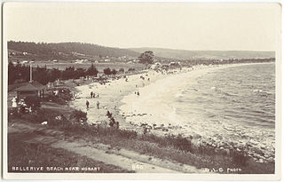
Bellerive Beach is a suburban beach along the River Derwent in Bellerive, Hobart, Tasmania. The south-facing beach is located near the historic Kangaroo Battery coastal defences to the west and Howrah Beach to the east. It offers views across the Derwent estuary to Howrah, Tranmere, and Sandy Bay. Bellerive Beach is accompanied by parkland featuring play equipment, barbecues, and bathroom facilities. The beach is also bordered by the Bellerive Oval, a tree-lined reserve, and private residences.
Taroona Beach is a popular beach destination along the River Derwent in Taroona, Hobart, Tasmania. The south facing beach looks directly out to Storm Bay and the Tasman Sea, with views of the Derwent estuary, the City of Clarence on the eastern shore, Opossum Bay, South Arm, the Alum Cliffs and northern tip of Bruny Island. Taroona Beach is situated between Hinsby Beach and Crayfish Point, home of the Fisheries and Aquaculture Centre for the Institute for Marine and Antarctic Studies. Taroona Beach contains a boat ramp and is backed by Taroona Park which contains bathroom facilities, a skate park, scout hall, the Taroona Tennis Club, and the Taroona Bowls and Community Club.

Hinsby Beach is a beach along the River Derwent in the Hobart suburb of Taroona, Australia. The south facing beach looks directly out to Storm Bay and the Tasman Sea, with views of the Derwent estuary, the Alum Cliffs, Taroona Shot Tower, the City of Clarence on the eastern shore and Opossum Bay, South Arm. Hinsby Beach is situated between the Alum Cliffs and Taroona Beach. A naturally secluded section of the beach, beyond the rocky south-western outcrop is a zoned naturist beach.


