Loving, New Mexico

Last updated

Loving, New Mexico
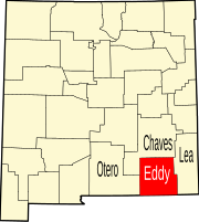
Eddy County New Mexico Incorporated and Unincorporated areas Loving Highlighted.svg
Location of Loving, New Mexico
Usa edcp location map.svg
Red pog.svg
Loving, New Mexico
Location in the United States
Coordinates: 32°17′10″N104°05′51″W / 32.28611°N 104.09750°W / 32.28611; -104.09750
Country United States
State New Mexico
County Eddy
Named for Oliver Loving
Area
[1]
  Total1.21 sq mi (3.13 km2)
  Land1.21 sq mi (3.12 km2)
  Water0.00 sq mi (0.00 km2)
Elevation
[2]
3,051 ft (930 m)
Population
 (2020) [3]
  Total1,390
  Density1,152.57/sq mi (444.91/km2)
Time zone UTC-7 (Mountain (MST))
  Summer (DST) UTC-6 (MDT)
ZIP code
88256
Area code 575
FIPS code 35-44420
GNIS feature ID2413569 [2]
Website villageofloving.org

Loving is a village in Eddy County, New Mexico. As of the 2010 census, the village population was 1,413. [4] Loving was settled by Swiss immigrants in the 1890s. [5]

Contents

Geography

Loving is located in southeastern Eddy County. U.S. Route 285 passes through the west side of the village, leading northwest 12 miles (19 km) to Carlsbad, the county seat, and southeast 74 miles (119 km) to Pecos, Texas. The Pecos River flows southwards 4 miles (6 km) east of Loving.

According to the United States Census Bureau, the village has a total area of 1.2 square miles (3.0 km2), all land. [4]

Demographics

Historical population
CensusPop.Note
1950 1,487
1960 1,64610.7%
1970 1,192−27.6%
1980 1,35513.7%
1990 1,243−8.3%
2000 1,3266.7%
2010 1,4136.6%
2020 1,390−1.6%
U.S. Decennial Census [6] [3]

As of the census [7] of 2000, there were 1,326 people, 441 households, and 339 families residing in the village. The population density was 1,168.7 inhabitants per square mile (451.2/km2). There were 516 housing units at an average density of 454.8 per square mile (175.6/km2). The racial makeup of the village was 57.69% White, 0.30% African American, 1.58% Native American, 36.88% from other races, and 3.54% from two or more races. Hispanic or Latino of any race were 78.28% of the population.

There were 441 households, out of which 43.1% had children under the age of 18 living with them, 58.5% were married couples living together, 12.0% had a female householder with no husband present, and 23.1% were non-families. 21.5% of all households were made up of individuals, and 10.0% had someone living alone who was 65 years of age or older. The average household size was 3.01 and the average family size was 3.49.

In the village, the population was spread out, with 34.6% under the age of 18, 8.1% from 18 to 24, 26.1% from 25 to 44, 19.3% from 45 to 64, and 11.8% who were 65 years of age or older. The median age was 31 years. For every 100 females, there were 101.2 males. For every 100 females age 18 and over, there were 105.0 males.

The median income for a household in the village was $22,414, and the median income for a family was $25,132. Males had a median income of $25,000 versus $16,250 for females. The per capita income for the village was $10,715. About 23.5% of families and 24.0% of the population were below the poverty line, including 26.5% of those under age 18 and 25.5% of those age 65 or over.

Education

It is within Loving Municipal Schools. [8] Loving High School was built in the late-1980s. [9] It has an active athletic program, especially in softball where it has won 19 state titles. Other state titles include three for football, one for basketball, four for baseball, and three for track.

Notable people

Related Research Articles

<span class="mw-page-title-main">Santa Fe County, New Mexico</span> County in New Mexico, United States

Santa Fe County is located in the U.S. state of New Mexico. As of the 2020 census, the population was 154,823, making it New Mexico's third-most populous county, after Bernalillo County and Doña Ana County. Its county seat is Santa Fe, the state capital.

<span class="mw-page-title-main">San Miguel County, New Mexico</span> County in New Mexico, United States

San Miguel County is a county in the U.S. state of New Mexico. As of the 2020 census, the population was 27,201. Its county seat is Las Vegas.

<span class="mw-page-title-main">Luna County, New Mexico</span> County in New Mexico, United States

Luna County(Spanish: Condado de Luna) is a county located in the U.S. state of New Mexico. As of the 2020 census, the population was 25,427. Its county seat is Deming. This county abuts the Mexican border. Luna County comprises the Deming, NM Micropolitan Statistical Area.

<span class="mw-page-title-main">Lea County, New Mexico</span> County in New Mexico, United States

Lea County is a county located in the U.S. state of New Mexico. As of the 2020 census, its population was 74,455.

<span class="mw-page-title-main">Eddy County, New Mexico</span> County in New Mexico, United States

Eddy County is a county located in the U.S. state of New Mexico. As of the 2020 census, the population was 62,314. Its county seat and largest city is Carlsbad. The county was created in 1891 and later organized in 1892. It is north of the Texas state line.

<span class="mw-page-title-main">Cibola County, New Mexico</span> County in New Mexico, United States

Cibola County is a county in the U.S. state of New Mexico. As of the 2020 census, the population was 27,172. Its county seat is Grants. It is New Mexico's youngest county, and the third youngest county in the United States, created on June 19, 1981, from the westernmost four-fifths of the formerly much larger Valencia County.

<span class="mw-page-title-main">Chaves County, New Mexico</span> County in New Mexico, United States

Chaves County is a county in New Mexico, United States. As of the 2020 census, the population was 65,157. Its county seat is Roswell. Chaves County was named for Colonel Jose Francisco Chaves, a military leader there during the Civil War and later in Navajo campaigns. The county was created by the New Mexico Territorial Legislature on February 25, 1889, out of land from Lincoln County.

<span class="mw-page-title-main">Fort Sumner, New Mexico</span> Village and county seat in De Baca County, New Mexico, United States

Fort Sumner is a village in and the county seat of De Baca County, New Mexico, United States. The population was 1,031 at the 2010 U.S. Census, down from the figure of 1,249 recorded in 2000. Fort Sumner is the spring and fall home of the Columbia Scientific Balloon Facility, and is home to the burial site of famed outlaw of the American West, Billy the Kid, who was shot and killed there in 1881.

<span class="mw-page-title-main">Artesia, New Mexico</span> City in New Mexico, United States

Artesia is a city in Eddy County, New Mexico, centered at the intersection of U.S. routes 82 and 285; the two highways serve as the city's Main Street and First Street, respectively. As of the 2020 census, the city population was 12,875.

<span class="mw-page-title-main">La Huerta, New Mexico</span> Census-designated place in New Mexico, United States

La Huerta, formerly known as Carlsbad North, is an unincorporated area and census-designated place (CDP) in Eddy County, New Mexico, United States. The population was 1,246 at the 2010 census. The community, whose name means "fruit garden" in Spanish, was named after the orchards and garden plots that supplied food to Carlsbad.

<span class="mw-page-title-main">Hope, New Mexico</span> Village in New Mexico, United States

Hope is a village in Eddy County, New Mexico, United States. It is located approximately 20 miles (32 km) west of Artesia on U.S. Route 82. It has had a post office since 1890. As of the 2010 census, the village's population was 105.

<span class="mw-page-title-main">Cloudcroft, New Mexico</span> Village in Otero County, New Mexico, United States

Cloudcroft is a village in Otero County, New Mexico, United States, and is located within the Lincoln National Forest. The population was 750 at the 2020 census.

<span class="mw-page-title-main">La Luz, New Mexico</span> CDP in New Mexico, United States

La Luz is a census-designated place (CDP) in Otero County, New Mexico, United States. The population was 1,615 at the 2000 census. It is located immediately north of Alamogordo and lies in the eastern edge of the Tularosa Basin and on the western flank of the Sacramento Mountains. Until 1848, La Luz was a part of Mexico. The CDP gets its name from the Spanish word for "light."

<span class="mw-page-title-main">Pecos, New Mexico</span> Village in New Mexico, United States

Pecos is a village in San Miguel County, New Mexico, United States. The population was 1,392 at the 2010 census, shrinking slower than other parts of San Miguel County, partly because Pecos is within commuting distance of Santa Fe. The village is built along the Pecos River, which flows from the north out of the Santa Fe National Forest. Notable locations nearby include Pecos National Historical Park, Glorieta Pass, Pecos Benedictine Monastery, and Lisboa Springs Trout Hatchery. It is also an entry point for hunting, fishing, hiking and camping in the Pecos Wilderness. The closest metropolitan area is the Santa Fe metropolitan area, approximately 26 miles (42 km) to the west.

<span class="mw-page-title-main">New Athens, Ohio</span> Village in Ohio, United States

New Athens is a village in Harrison County, Ohio, United States. The population was 222 at the 2020 census.

<span class="mw-page-title-main">Wakeman, Ohio</span> Village in Ohio, United States

Wakeman is a village in Huron County, Ohio, United States, along the Vermilion River. Its namesake was Jesup Wakeman, an early settler of Fairfield County, Connecticut, who was involved in western land speculation between 1800 and 1840. The population was 990 at the 2020 census.

<span class="mw-page-title-main">Lowry Crossing, Texas</span> City in Texas, United States

Lowry Crossing is a city in Collin County, Texas, United States. The population was 1,689 at the 2020 census.

<span class="mw-page-title-main">Pecos, Texas</span> City in Texas, United States

Pecos is the largest city in and the county seat of Reeves County, Texas, United States. It is in the valley on the west bank of the Pecos River at the eastern edge of the Chihuahuan Desert, in the Trans-Pecos region of West Texas and just south of New Mexico's border. Its population was 12,916 at the 2020 census. On January 24, 2012, Pecos City appeared on the Forbes 400 as the second-fastest growing small town in the United States. The city is a regional commercial center for ranching, oil and gas production, and agriculture. The city is most recognized for its association with the local cultivation of cantaloupes. Pecos claims to be the site of the world's first rodeo on July 4, 1883.

<span class="mw-page-title-main">Toyah, Texas</span> Town in Texas, United States

Toyah is a town in Reeves County, Texas, United States. The population was 61 in the 2010 census.

Milltown is a town in Polk County, Wisconsin, United States. The population was 1,146 at the 2000 census. The village of Milltown is located within the town.

References

  1. "ArcGIS REST Services Directory". United States Census Bureau. Retrieved October 12, 2022.
  2. 1 2 U.S. Geological Survey Geographic Names Information System: Loving, New Mexico
  3. 1 2 "Census Population API". United States Census Bureau. Retrieved October 12, 2022.
  4. 1 2 "Geographic Identifiers: 2010 Demographic Profile Data (G001): Loving village, New Mexico". U.S. Census Bureau, American Factfinder. Retrieved February 18, 2016.[ dead link ]
  5. Julyan, Robert (1996). The Place Names of New Mexico. University of New Mexico Press. p. 217. ISBN   0826316891.
  6. "Census of Population and Housing". Census.gov. Retrieved June 4, 2015.
  7. "U.S. Census website". United States Census Bureau . Retrieved January 31, 2008.
  8. "2020 CENSUS - SCHOOL DISTRICT REFERENCE MAP: Eddy County, NM" (PDF). U.S. Census Bureau . Retrieved June 28, 2022.
  9. Sizer, Theodore R. (1992). Horace's School: Redesigning the American High School. Houghton Mifflin Harcourt. ISBN   978-0-395-75534-1.