Main Street station (Toronto)

Last updated • 5 min readFrom Wikipedia, The Free Encyclopedia

Main Street
TTC - Line 2 - Bloor-Danforth line.svg
Main Street Station Exterior 2022.jpg
Station exterior
General information
Location315 Main Street
Toronto, Ontario
Canada
Coordinates 43°41′21″N79°18′06″W / 43.68917°N 79.30167°W / 43.68917; -79.30167
Platforms Side platforms
Tracks2
Connections
  •  20  Cliffside
  •  23  Dawes
  •  62  Mortimer
  •  64  Main
  •  87  Cosburn
  •  113  Danforth
  •  135  Gerrard
  •  300 Symbol ksiezyc.svg   Bloor–Danforth
BSicon CLRV.svg   506   306 Symbol ksiezyc.svg   Carlton
GO Transit logo.svg Lakeshore East line GO logo.png GO Stouffville logo.svg Danforth GO
Construction
Structure typeUnderground
AccessibleYes
Other information
Website Official station page
History
OpenedMay 10, 1968;56 years ago (1968-05-10)
Passengers
2023–2024 [1] 18,682
Rank39 of 70
Services
Preceding station Logo of the Toronto Transit Commission.svg Toronto Transit Commission Following station
Woodbine
towards Kipling
Line 2 Bloor–Danforth Victoria Park
towards Kennedy
Danforth Avenue 506 Carlton Terminus
Location
Main Street station (Toronto)

Main Street is a station on Line 2 Bloor–Danforth in Toronto, Ontario, Canada and is located on the east side of Main Street a short distance north of Danforth Avenue. Connections to GO Transit's commuter train service on the Lakeshore East line can be made at Danforth GO Station, approximately 300 metres to the south on the east side of Main Street.

Contents

Description

Platform Main Street Station Platform 2022.jpg
Platform
Street level Main Street Station Bus Waiting Area 2022.jpg
Street level
Concourse level Main Street Station Concourse Level 2022.jpg
Concourse level

The TTC station is roughly rectangular in shape and has 3 levels: street level, concourse level and platform level. The bus bays, streetcar platform and fare gates are located at street level. There are 5 bus bays on the north and east sides of the station building. The south side of the building is occupied by a single, long streetcar platform on the inside of a clockwise streetcar loop encircling the building that serves as the eastern terminus of the 506 Carlton streetcar (306 Carlton at night).The bus bays and streetcar platform are behind the fare gates inside the fare-paid area. A set of 2 opposing stairwells lead down to the concourse level, where a single up-only escalator leads back to street level. The concourse level is home to a Gateway Newsstand. From the concourse, 2 more sets of opposing stairwells on the north and south sides of the concourse level lead down to the platforms, with up-only escalators connecting both platforms to the concourse.

This station became wheelchair accessible in 2004. [2] One elevator near the southeast corner of the station building provides access from street level to the concourse level of the eastbound subway platform; a second elevator in the northwest corner provides a connection between the concourse level and the westbound subway platform. [3] To facilitate accessibility, automatic sliding doors were added at the street entrance and on the north side of the station building to access the bus bays, along with an accessible fare gate and improved signage. [4] A space is reserved for Wheel-Trans vehicles.

History

Main Street station opened on May 10, 1968, as part of the first round of extensions to Line 2, which had opened 2 years earlier between Keele and Woodbine. Line 2 opened between Warden and Islington in 1968, with 1-stop extensions to Kennedy and Kipling opening in 1980. [5] Main Street station was built on the site of the former Main streetcar loop that opened on May 15, 1955, as the eastern terminus of the Carlton streetcar line (today route 506 Carlton). Main Loop was built to relieve congestion at Luttrell Loop, which had been the previous terminus of the Carlton streetcar since 1923. Between April 25 and June 13, 1966, the 1955 loop was closed to build a new streetcar loop for Main Street subway station. During construction, Carlton streetcars temporarily returned to Luttrell Loop. Carlton streetcars started using the new station loop in 1966, before the subway platforms at the station were open to the public in 1968. [6]

Unlike most TTC stations, its name includes the word "Street" in order to avoid the possible misreading that it is the subway's "main" station. It is named after Main Street, which was the main street of the suburban town of East Toronto, which was amalgamated into Toronto in 1908.

The station was initially built with its turnstiles and collector booths on the concourse level between the bus and streetcar terminal and the subway platforms, because until 1973, some of the buses serving the station crossed the fare zone boundary between Toronto and the then-city of Scarborough.[ citation needed ] When the fare zone system was abolished in 1973, the fare gates were moved upstairs to street level, to bring the bus bays and streetcar platform into the fare-paid area. Because of this, Main Street station has a larger concourse compared to many other subway stations on Line 2, particularly those directly to the east which were built as part of the original section of Line 2 opened in 1966.

Main–Danforth has been identified by Metrolinx as a transportation mobility hub as it is located at the interchange of two or more current or planned regional rapid transit lines. [7] As a result, Main Street was the first subway station to be outfitted with new accessible paddle-style Presto fare gates, which replaced the existing tripod turnstiles system-wide and are used with Presto cards [8] across the subway system.

Danforth GO Station is a station on the Lakeshore East Line, located approximately 300 metres (980 ft) south of the station along Main Street. The station has also sporadically served trains on the Stouffville Line. The 2 stations are within walking distance of each other and an accessible ramp exists at Danforth GO, but the path follows Main Street on the sidewalk for most of its distance and is exposed to the elements.

The TTC closed the bus and streetcar loop at Main Street station between May 7, 2023, and September 2023 for infrastructure upgrades. The work included concrete and asphalt pavement rehabilitation within the bus loop, concrete bus platform rehabilitation including the installation of tactile walking surface indicator, and fencing replacement throughout the loop. Construction activities were set to continue until the end of November 2023. [9]

Subway infrastructure in the vicinity

East of the station the tracks angle north away from Danforth Avenue and emerge to run on the surface at the Tyra Portal in Dentonia Park, just west of Victoria Park station. To the west the subway tunnel was mostly constructed by cut-and-cover along Harris Avenue from Woodbine station.

Surface connections

TTC routes serving the station include:

RouteNameAdditional information
20CliffsideEastbound to Kennedy station
23DawesNorthbound to St. Clair Avenue East
62MortimerWestbound to Hennick Bridgepoint Hospital via Broadview station
64MainSouthbound to Queen Street East
87ACosburnWestbound to Broadview station via East York Acres
87CWestbound to Broadview station
113DanforthWestbound to Kennedy station
135GerrardEastbound to Warden station
306Carlton Blue Night Streetcar service to High Park Loop
506 CarltonStreetcar; westbound to High Park Loop

Related Research Articles

<span class="mw-page-title-main">St. Clair West station</span> Toronto subway station

St. Clair West is a subway station on Line 1 Yonge–University in Toronto, Ontario, Canada. It spans the block north of St. Clair Avenue West to Heath Street, between Bathurst Street and Tweedsmuir Avenue. The station serves the local communities of Forest Hill South, Humewood, Bracondale Hill and Casa Loma.

<span class="mw-page-title-main">Spadina station</span> Toronto subway station

Spadina is a subway station on Line 1 Yonge–University and Line 2 Bloor–Danforth in Toronto, Ontario, Canada. It is located on Spadina Road, north of Bloor Street West. It is one of only three stations open overnight, along with Queens Quay station and Union station.

<span class="mw-page-title-main">Union station (TTC)</span> Toronto subway station

Union is a subway station on Line 1 Yonge–University of the Toronto subway in Toronto, Ontario, Canada. It opened in 1954 as one of twelve original stations on the first phase of the Yonge line, the first rapid transit line in Canada. It was the southern terminus of the line until the opening of the University line in 1963, and is today the inflection point of the U-shaped line. Along with Spadina station and Queens Quay station, it is one of three stations open overnight to support late-night streetcar routes.

<span class="mw-page-title-main">Queen station</span> Toronto subway station

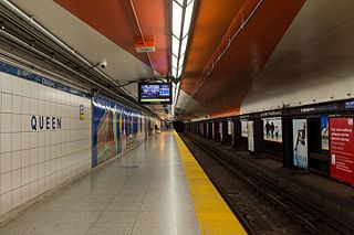
Queen is a subway station on Line 1 Yonge–University in Toronto, Ontario, Canada. It is located under Yonge Street north from Queen Street to Shuter Street.

<span class="mw-page-title-main">Bloor–Yonge station</span> Toronto subway station

Bloor–Yonge is a subway station on Line 1 Yonge–University and Line 2 Bloor–Danforth in Toronto, Ontario, Canada. Located in Downtown Toronto, under the intersection of Yonge Street and Bloor Street, it is the busiest subway station in the system, handling over 200,000 passengers on an average weekday.

<span class="mw-page-title-main">St. Clair station</span> Toronto subway station

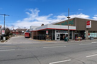
St. Clair is a subway station on Line 1 Yonge–University in Toronto, Ontario, Canada. The station opened in 1954 as part of the original Yonge Street subway.

<span class="mw-page-title-main">Eglinton station</span> Toronto subway station

Eglinton is a subway station on Line 1 Yonge–University of the Toronto subway. Located on Eglinton Avenue, it is central to the Yonge–Eglinton neighbourhood in Midtown Toronto. Eglinton station is the seventh busiest station of the Toronto Transit Commission (TTC).

<span class="mw-page-title-main">Finch station</span> Toronto subway station

Finch is the northern terminus subway station of the eastern section of Line 1 Yonge–University in Toronto, Ontario, Canada. It is located under Yonge Street, north of Finch Avenue.

<span class="mw-page-title-main">Don Mills station</span> Toronto subway station

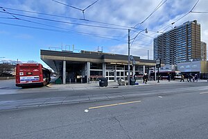
Don Mills is a subway station that is the eastern terminus of Line 4 Sheppard in Toronto, Ontario, Canada. The station is at the northeast corner of Sheppard Avenue East and Don Mills Road, within the residential communities of Don Valley Village and Henry Farm, adjacent to Fairview Mall. The station is close to Highways 401 and 404, as well as the Don Valley Parkway. Other nearby landmarks include Georges Vanier Secondary School and the Fairview branch of the Toronto Public Library.

<span class="mw-page-title-main">Kennedy station</span> Toronto subway station

Kennedy is the eastern terminal station on Line 2 Bloor–Danforth of the Toronto subway system. Opened in 1980, it is located east of the Kennedy Road and Eglinton Avenue intersection. With the adjacent Kennedy GO station on the Stouffville line of GO Transit, Kennedy is an intermodal transit hub and the fifth busiest station in the system, after Bloor–Yonge, St. George, Sheppard–Yonge, and Union, serving a total of approximately 42881 customer trips a day.

<span class="mw-page-title-main">Kipling station</span> Toronto subway station

Kipling is the western terminus station of Line 2 Bloor–Danforth of the Toronto subway system. The station is served by buses and subway trains operated by the Toronto Transit Commission and is adjacent to the Kipling GO Station on the Milton line of GO Transit and the Kipling Bus Terminal, where passengers can connect with MiWay and GO Transit bus services. It opened on November 21, 1980, as part of the extensions west, to this station, and east to Kennedy station. It is located in the Islington–City Centre West neighbourhood on St. Albans Road at Aukland Road, west of the overpass of Kipling Avenue, after which the station is named. The 900 Airport Express bus route connects Kipling to the Toronto Pearson International Airport.

<span class="mw-page-title-main">Islington station (Toronto)</span> Toronto subway station

Islington is a subway station on Line 2 Bloor–Danforth of the Toronto subway in Toronto, Ontario, Canada. It is located on the north side of Bloor Street West on the west side of Islington Avenue. A central platform serves trains running in both directions.

<span class="mw-page-title-main">Royal York station</span> Toronto subway station

Royal York is a subway station on Line 2 Bloor–Danforth of the Toronto subway in Toronto, Ontario, Canada. It is located just north of Bloor Street West on the east side of Royal York Road.

<span class="mw-page-title-main">Dundas West station</span> Toronto subway station

Dundas West is a subway station on Line 2 Bloor–Danforth of the Toronto subway in Toronto, Ontario, Canada. It is located just north of Bloor Street West at the corner of Dundas Street and Edna Avenue. The station is about 200 metres west of Bloor GO Station on the GO Transit Kitchener line and the Union Pearson Express.

<span class="mw-page-title-main">Keele station</span> Toronto subway station

Keele is a subway station on Line 2 Bloor–Danforth of the Toronto subway in Toronto, Ontario, Canada. It is located just north of Bloor Street West on the east side of Keele Street. The station opened in 1966, and was the western terminus of the line until 1968.

<span class="mw-page-title-main">Pape station</span> Toronto subway station

Pape is a subway station on Line 2 Bloor–Danforth in Toronto, Ontario, Canada. The station opened in 1966 and is located in Toronto's Greektown neighbourhood at the northeast corner of Pape Avenue and Lipton Avenue, just north of Danforth Avenue. It is located at the site of the former Lipton loop.

<span class="mw-page-title-main">Coxwell station</span> Toronto subway station

Coxwell is a subway station on the Line 2 Bloor–Danforth in Toronto, Ontario, Canada. The station is located on Strathmore Boulevard just east of Coxwell Avenue and one block north of Danforth Avenue. It opened in 1966 as part of the original segment of the Bloor–Danforth line. Automatic sliding doors, accessible fare gates and the addition of elevators made the station fully accessible in late December 2017.

<span class="mw-page-title-main">Woodbine station</span> Toronto subway station

Woodbine is a subway station on Line 2 Bloor–Danforth in Toronto, Ontario, Canada. The station is at the southeast corner of Woodbine Avenue and Strathmore Boulevard, just north of Danforth Avenue.

<span class="mw-page-title-main">Danforth GO Station</span> Railway station in Toronto, Ontario, Canada

Danforth GO Station is a railway station on GO Transit's Lakeshore East line in Toronto, Ontario, Canada. The station is situated in the east end of Old Toronto, south west of the intersection of Main Street and Danforth Avenue. The station is a short walk from Main Street station on Line 2 Bloor–Danforth of the Toronto subway.

<span class="mw-page-title-main">506 Carlton</span> Streetcar route in Toronto, Canada

506 Carlton is a Toronto streetcar route run by the Toronto Transit Commission in Ontario, Canada. It runs from Main Street station on subway Line 2 Bloor–Danforth along Gerrard, Carlton and College Streets to High Park. Despite the route's name, less than 10 percent of its length actually uses Carlton Street.

References

  1. "Subway ridership, 2023–2024" (PDF). Toronto Transit Commission. Retrieved November 12, 2024. This table shows the typical number of customer-boardings made on each subway line and the number of customers travelling to and from each station platform on a typical weekday in Sep 2023–Aug 2024.
  2. "Main Street Subway Station Becomes Accessible". Canadian Newswire. November 22, 2004. Archived from the original on June 13, 2011. Retrieved August 1, 2012.
  3. "Installation of elevators at Main Street Station" (PDF). Construction News. Toronto Transit Commission. Archived from the original on December 10, 2017. Retrieved August 1, 2012.
  4. "Main Street: Accessible Alternative". Archived from the original on September 2, 2012. Retrieved August 17, 2012.
  5. "2013 TTC Operating Statistics". Toronto Transit Commission. Archived from the original on August 16, 2021. Retrieved January 14, 2015.
  6. Bow, James (September 6, 2017). "Route 506 - The Carlton Streetcar". Transit Toronto. Archived from the original on January 8, 2018. Retrieved January 25, 2018.
  7. "Main-Danforth Mobility Hub Profile" (PDF). Metrolinx. September 19, 2012. Archived from the original (PDF) on February 6, 2017. Retrieved May 1, 2013.
  8. Novakovic, Stefan (April 8, 2016). "Three Levels of Government Unveil Presto Gates at Main Street". Urban Toronto. Archived from the original on April 12, 2016. Retrieved April 11, 2016.
  9. "Main Street Station - Bus and streetcar loop closure". Toronto Transit Commission . Archived from the original on May 4, 2023. Retrieved May 4, 2023.