Manlio Fabio Altamirano | |
---|---|
City and municipality | |
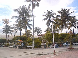
![]() Manlio Fabio Altamirano main plaza | |
Coordinates: 19°06′01″N96°20′28″W / 19.10028°N 96.34111°W | |
Country | ![]() |
State | Veracruz |
Region | Sotavento Region |
Government | |
• Mayor | Ana Lilia Arrieta Gutiérrez (MORENA) |
Area | |
• Total | 246.8 km2 (95.3 sq mi) |
Population | |
• Total | 23,918 |
• Density | 96.9/km2 (251/sq mi) |
• Seat | 6,084 |
Time zone | UTC-6 (CST) |
• Summer (DST) | UTC-5 (CDT) |
Website | Official Website |
Year | Pop. | ±% |
---|---|---|
1995 | 20,562 | — |
2000 | 20,580 | +0.1% |
2005 | 20,374 | −1.0% |
2010 | 22,585 | +10.9% |
2015 | 23,404 | +3.6% |
2020 | 23,918 | +2.2% |
[1] |
Manlio Fabio Altamirano (also, Manlio Favio Altamirano and Altamirano) is a town in the Mexican state of Veracruz. It serves as the municipal seat for the surrounding municipality of the same name. As 2020 the municipality had a population of 23,918, about 25% resides in the municipal seat (6,084 hab.). [1] Other localities includes Mata Loma (2,121 hab.), Tenenexpan (2,050 hab.), Loma de los Carmona (1,183 hab.) and El Sauce (865 hab.). [1]
Jalacingo is a municipality located in the central area of the Mexican state of Veracruz, in the region called the Capital, on the border with the state of Puebla. It is located at the coordinates 19°36'N 97°13'W, the city has a height of 1860 meters above sea level, while the height of the municipality varies from 600 to 2900 meters above sea level.
Emiliano Zapata is a municipality in the Mexican state of Veracruz. It is located 2 km from Jalapa-Enríquez on Federal Highways 180 and 190. The municipality is named for the hero of the Mexican Revolution, Emiliano Zapata. The municipal seat is at Dos Ríos.
Cotaxtla is a town and municipality in the Mexican state of Veracruz. It is located 45 km from the city of Veracruz on Federal Highway 180.
Las Vigas de Ramírez is a city in the Mexican state of Veracruz. It serves as the municipal seat for the surrounding municipality of the same name. The city was established by decree on 23 November 1523, named after the teacher Rafael Ramírez Castañeda (1884–1959).
Ixhuacán, or Ixhuacán de los Reyes, is a city in the Mexican state of Veracruz. It is located approximately 36 km (22 mi) from Xalapa Enríquez; Federal Highway 123 runs through it. It is bordered by Teocelo, Xico and Coatepec. Coffee is the chief product of Ixhuacán de los Reyes.
Jamapa is a municipality in the Mexican state of Veracruz which stands on Federal Highway 137. Its name comes from Nahuatl Xam-a-pan, meaning 'in the river of the adobes'. The municipality was established on 17 February 1870.
Altamirano may refer to:
Alvarado is a municipality in the Mexican state of Veracruz. The municipality is part of the state's Papaloapan Region and its municipal seat is established at the homonymous city of Alvarado.
Actopan is a municipality located at 19°30′N96°37′W in the montane central zone in the Mexican state of Veracruz, about 50 km from the state capital of Xalapa. Actopan, the municipal seat, is a small city located near the capital of the state. The region is one of the most important producers of mangoes in the state.
Cazones de Herrera, or Cazones, is a town and municipality located in the north of the Mexican state of Veracruz on the Gulf of Mexico. While it has tourist attractions along its shore, especially in the Barra de Cazones area, the municipality, including the seat, has a high level of socioeconomic marginalization. Most of the municipality's population works in agriculture.
Cosautlán is a municipality in the Mexican state of Veracruz. It is located in the montane central zone of the state, about 23.5 km from Xalapa, the state capital. It has a surface of 72.38 km2. It is located at 19°20′N96°59′W. The town has 2224 men and 2393 women.
Landero y Coss is a municipality in the Mexican state of Veracruz.
Medellín is a municipality in the Mexican state of Veracruz. The municipal seat is the town of Medellín.
Miahuatlán is a municipality in the Mexican state of Veracruz.
Rafael Lucio is a municipality located in the montane central zone of the Mexican state of Veracruz, about 9 km from the state capital Xalapa. It has a surface of 24.68 km2. It is located at 19°35′N96°59′W.
Soledad de Doblado is a municipality located in the semiarid zone of the center of the Mexican state of Veracruz, in the plains of the Sotavento of Veracruz, about 75 km from the state capital of Xalapa. It has a surface of 370.96 km2. It is located at 19°03′N96°25′W. On June 16, 1896, by Decree the town was named Soledad de Doblado, in honor of Manuel Doblado, who signed in this place, on February 19, 1862, the preliminary agreements with the representatives of England, Spain and France. By a decree of November 16, 1961 it rose to the category of city.
Tepetlán is a municipality located in the montane central zone in the Mexican state of Veracruz. It has a surface of 83.90 km2. During the Pre-Hispanic epoch it was inhabited by the Totonac, the most ancient date in the one that one alludes as municipality in that of the 1 °. Of December, 1868 In the Cologne it named the village San Antonio Tepetlán, for decree of November 5, 1932, the head-board is called Tepetlán, remaining suppressed the first part of the name.
Banderilla is a municipality in the Mexican state of Veracruz. It is located about 9 km from the state capital, Xalapa. It has a surface area of 22.21 km2. It is located at 19°35′N96°56′W.
″La Martucha″ La Martucha is a community in the Mexican state, Veracruz de Ignacio de la Llave, part of Manlio Fabio Altamirano town. La Martucha is located in the central area of Sotaventoplainnear by Veracruz Port and about five kilometers southwest of the county seat, Manlio Fabio Altamirano. La Martucha has 19 ° 04 ' 39 " N and 96 ° 17'36 " W geographic coordinates, at an altitude of 30 meters above sea level. According to the results with the 2005 Census of Population and Housing conducted by the National Institute of Statistics and Geography. The population of Martucha is a total of 83 citizens, which 42 are men and 41 are women. On September 17, 2010, La Martucha town was severely affected by the flooding of the nearby river, Jamapa, which destroyed about 80% of buildings, as a consequence of heavy rainfall, Hurricane Karl.
Las Minas is a municipality in the Mexican state of Veracruz, located 28 kilometres (17 mi) northeast of the state capital Xalapa.