Feni River is a river in the Indian state of Tripura and southeastern Bangladesh. It is a trans-boundary river with an ongoing dispute about water rights. The Feni River originates in South Tripura district and flows through Sabroom town and then enters Bangladesh. Muhuri River, also called Little Feni, from Noakhali District joins it near its mouth. The river is navigable by small boats as far as Ramgarh, about 80 kilometres (50 mi) upstream.
Habiganj, formerly known as Habibganj, which was named after its founder Syed Habib Ullah of Taraf kingdom, is a district of the Sylhet Division in the north-eastern part of Bangladesh. Between and thirteenth and early seventeenth centuries, Habiganj was part of the state of Nasirabad. At present, it is a district of Sylhet Division.

Moulvibazar also spelled Maulvibazar, Moulavibazar, and Maulavibazar, is the southeastern district of Sylhet Division in northeastern Bangladesh, named after the town of Moulvibazar. It is bordered by the Indian states of Tripura and Assam to the south and east, respectively; and by the Bangladeshi districts of Habiganj to the west and Sylhet to the north.
The Battle of Dhalai was a battle in the Bangladesh Liberation War. It was an Indian attack from Tripura into East Pakistan to stop Pakistani cross-border shelling.

Sabroom is a town and a nagar panchayat in South Tripura district in the Indian state of Tripura.
Khowai River is a trans-boundary river that originates in the eastern part of the Atharamura Hills of Tripura in India. Flowing north-north-west, it leaves India at Khowai, and enters Bangladesh at Balla in Habiganj District. The river passes east of Habiganj town, where it is under pressure from encroachment and pollution. North of town it turns west, and joins the Kushiyara near Adampur in Lakhai Upazila, Kishoreganj District.

Chhagalnaiya is an Upazila of Feni District in the Division of Chittagong, Bangladesh.
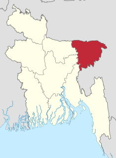
Matiranga is an Upazila of Khagrachari District in the Division of Chittagong, Bangladesh.
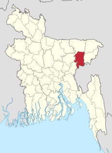
Ajmiriganj is an Upazila of Habiganj District in the Division of Sylhet, Bangladesh.

The Surma River is a major river in Bangladesh, part of the Surma-Meghna River System. It starts when the Barak River from northeast India divides at the Bangladesh border into the Surma and the Kushiyara rivers. It ends in Kishoreganj District, above Bhairab Bāzār, where the two rivers rejoin to form the Meghna River. The waters from the river ultimately flow into the Bay of Bengal.
The Surma-Meghna River System is a river complex in the Indian Subcontinent, one of the three that form the Ganges Delta, the largest on earth. It rises in the Manipur Hills of northeast India as the Barak River and flows west becoming the Surma River and then flows south as the Meghna River, a total of 946 kilometres (588 mi) of which 669 kilometres (416 mi) are within Bangladesh, to the Bay of Bengal.
The Government of Tripura also known as the State Government of Tripura, or locally as State Government, is the supreme governing authority of the Indian state of Tripura and its 8 districts. It consists of an executive, led by the Governor of Tripura, a judiciary and a legislative branch.

Comilla Jagannath Temple, also known as Sateroratna Mandir or seventeen-jewel temple, is located in Comilla, Bangladesh. It is dedicated to the Hindu God Jagannath. It dates back to the 16th century and was built by Sree Sreejoktou Moharaja Rada Kishor Manikuo Bahadur, who was the king of Tripura. The deities of Jagannath, Balabhadra and Subhadra were originally installed in a temple in Tripura from where they were subsequently shifted to this temple.
Manu is a village in Dhalai Tripura district, Tripura, India. It falls under Tripura East Lok Sabha Constituency.
Moulvibazar is a town in north-eastern Bangladesh just south of Sylhet. It is the capital of Moulvibazar Sadar Upazila and Moulvibazar District. Moulvibazar is located on the banks of the Manu River. The city has a high population density. The Moulvibazar region is well known for its tea gardens and tropical forests. The most of the tea gardens of Bangladesh is in Moulvibazar.
On 12 October 1988, activists of the Indian National Congress attacked a Communist Party of India (Marxist) office in Birchandra Manu village, Belonia sub-division in southern Tripura, India. The attack took place whilst the CPI(M) cadres were hoisting a red flag to mark the re-opening of their local party office at 4 pm. Present at the hoisting ceremony were two prominent CPI(M) leaders, the Tripura Tribal Areas Autonomous District Council member Sridam Pal and the Tripura Legislative Assembly member Brajamohan Jamatia.

The Dhalai River a trans-boundary river in India and Bangladesh. It rises in the mountains of the Indian state of Tripura. It enters Kulaura Upazila of Maulvi Bazar District of Bangladesh. Later it joins Manu River in Rajnagar Upazila. The co-ordinates of Dhalai River at Ambassa are 23.55'128'' N and 91.51'204'' E in degrees minutesseconds(DMS). It originate from Atharamura Hill and is 117 kilometres (73 mi) long. Some of the popular riverside township of Dhalai River are Ambassa town, Baralutma and Kamalpur town.
The Juri River is a trans-boundary river in India and Bangladesh. It rises in the Jampui Hills of the Indian state of Tripura. It enters Kulaura Upazila of Maulvi Bazar District of Bangladesh. Later it joins Kushiyara River.

The Longai River is a trans-boundary river in India and Bangladesh. It rises in the Jampui Hills of the Indian state of Tripura. It enters Karimganj district of Assam. Later it enters Bangladesh, and drains in Hakaluki Haor.

A magnitude 5.7 earthquake struck India 20 km (12 mi) east north-east of Ambassa in the state of Tripura on January 5, 2017 with a maximum observed intensity of 6-7 EMS. It struck at 2:39 pm local time, and was centered in an isolated area. The estimated depth was 32.0 km.