Marakkara

Last updated

Marakkara
Grama Panchayath
Marakkara.jpg
Kadampuzha temple.jpg
Kadampuzha Town.jpg
FHC Marakkara.png
India Kerala location map.svg
Red pog.svg
Marakkara
Location in Kerala, India
India location map.svg
Red pog.svg
Marakkara
Marakkara (India)
Coordinates: 10°57′0″N76°2′0″E / 10.95000°N 76.03333°E / 10.95000; 76.03333
CountryFlag of India.svg India
State Kerala
District Malappuram
Government
  TypeGrama Panchayath
Area
  Total
27.00 km2 (10.42 sq mi)
Elevation
127.0 m (416.7 ft)
Population
 (2011)
  Total
40,404
  Density1,500/km2 (3,900/sq mi)
Languages
  Official Malayalam, English
Time zone UTC+5:30 (IST)
PIN
676553
Vehicle registration KL-55, KL-10

Marakkara is a Grama Panchayath in Kuttippuram Block Panchayat, Tirur Taluk, Malappuram district in the state of Kerala, India. [1]

Contents

Kadampuzha Temple

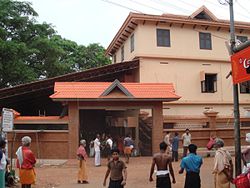
The famous Kadampuzha Devi Temple is situated inside the Marakkara panchayath.Kadampuzha Devi Temple is a Hindu temple and pilgrimage center at Kadampuzha in Malappuram district, Kerala, India. The main deity of this temple is Goddess Parvati/Durga in the form of a huntress. There is no idol of Goddess in this temple, and she is worshipped in a pit. The presence of Lord Ganesha is also believed to be with the Goddess, and there are sub-shrines for Lord Sastha and serpent deities. A separate Shiva temple exists near the temple, called 'Madambiyarkavu'. Both these temples are under the control of Malabar Devaswom Board.

Transportation

Marakkara village connects to other parts of India through valanchery town. National highway No.66 passes through valanchery and the northern stretch connects to Goa and Mumbai. The southern stretch connects to Cochin and Trivandrum. State Highway No.28 starts from Nilambur and connects to Ooty, Mysore and Bangalore through Highways.12,29 and 181. National Highway No.966 connects to Palakkad and Coimbatore. The nearest airport is at Kozhikode. The nearest major railway station is at Tirur.

Demographics

As of 2011 India census, Marakkara had a population of 40,404, with 18,999 males and 21,405 females. [1]

Administration

Marakkara is a Grama Panchayath, divided into 20 wards.[ citation needed ]

Villages

No.Name
1Marakkara
2 Melmuri

Wards

Ward no.Name
1Randathani
2Marakkara
3Erkkara
4Maruthinchira
5Melmuri
6Parappur
7Karekkad North
8Chithrampally
9Majeedkundu
10Jarathingal
11Malayil
12Neeradi
13Pilathara
14Kadampuzha
15Chullikkad
16A.C.nirapp
17Kallarmangalam
18Chelakuth
19Poovanchina
20Attuppuram

Election results

Panchayath election 2020

marakkara panchayath Election 2020 [2]

S.No.Party NameParty symbolNumber of Members
01 UDF UDF logo.png 15
02Independents No flag.svg 03
03 LDF Left Democratic Front (Kerala) Logo.svg 02

Panchayath election 2015

Marakkara panchayath Election 2015 [3]

S.No.Party NameParty symbolNumber of Members
01Independents No flag.svg 12
02 UDF UDF logo.png 8
03 LDF Left Democratic Front (Kerala) Logo.svg 0

Panchayath election 2010

Marakkara panchayath Election 2015 [4]

S.No.Party NameParty symbolNumber of Members
01 UDF UDF logo.png 16
02Independents No flag.svg 02
03 LDF Left Democratic Front (Kerala) Logo.svg 02

Panchayath election 2005

Marakkara panchayath Election 2005

S.No.Party NameParty symbolNumber of Members
01 UDF UDF logo.png 09
02Independents No flag.svg 10
03 LDF Left Democratic Front (Kerala) Logo.svg 00

Marakkara Panchayat

See also

References

  1. 1 2 "Census of India : Villages with population 5000 & above". Registrar General & Census Commissioner, India. Archived from the original on 8 December 2008. Retrieved 10 December 2008.
  2. "Marakkara Panchayath election 2020". lbtrend. Archived from the original on 9 March 2021. Retrieved 11 December 2020.
  3. "Marakkara panchayath 2015". lsgkerala.gov.in.
  4. "Marakkara Panchayath election 2015". lsgkerala.gov.in.