Mbarara–Ntungamo–Kabale–Katuna Road

Last updated

Mbarara–Ntungamo–Kabale–Katuna Road
Route information
Length77.7 mi (125.0 km)
HistoryDesignated in 2011
Completion in 2018
Major junctions
North end Mbarara
  Ntungamo
Kabale
South end Katuna

Mbarara–Ntungamo–Kabale–Katuna Road is a road in the Western Uganda, connecting the city of Mbarara, in Mbarara District, with the towns of Ntungamo, Kabale and Katuna at the international border with the Republic of Rwanda. [1]

Mbarara District District in Uganda

Mbarara District is a district in South Western Uganda. The district was named after its chief municipal centre, the city of Mbarara, where the district headquarters are located.

Contents

Location

The road starts at Mbarara (pop. 195,238), [2] the largest city in the Western Region of Uganda. It continues in a southwesterly direction through Ntungamo and Kabale to end at Katuna at the international border with Rwanda, a distance of about 125 kilometres (78 mi) [1] The coordinates of the road, immediately south of Ntungamo are:0°54'10.0"S, 30°15'14.0"E (Latitude:-0.902778; Longitude:30.253889). [3]

Western Region, Uganda Region in Western, Uganda

The Western region is one of four regions in the country of Uganda. As of Uganda's 2014 census, the region's population was 8,874,862.

Uganda republic in East Africa

Uganda, officially the Republic of Uganda, is a landlocked country in East-Central Africa. It is bordered to the east by Kenya, to the north by South Sudan, to the west by the Democratic Republic of the Congo, to the south-west by Rwanda, and to the south by Tanzania. The southern part of the country includes a substantial portion of Lake Victoria, shared with Kenya and Tanzania. Uganda is in the African Great Lakes region. Uganda also lies within the Nile basin, and has a varied but generally a modified equatorial climate.

Ntungamo Place in Uganda

Ntungamo is a town in the Western Region of Uganda. It is the largest town in Ntungamo District and the site of the district headquarters. It is the hometown of longtime President Yoweri Museveni.

Upgrading to bitumen

In December 2010, the European Union extended a grant of USh325 billion (approximately €116 million at that time), to improve the 125 kilometres (78 mi), stretch of the East African Northern Corridor, between Mbarara and Katuna. The road was divided into two sections: (a) Mbarara-Ntungamo Section, was budgeted at UShs154 billion (€51 million) and (b) Ntungamo-Katuna Section was budgeted at UShs198.26 billion (€65 million). The Ugandan government was budgeted to contribute 8 percent of the grant value (approximately €9.28 million). [1] The construction contract was awarded to Reynolds Construction Company of Switzerland, the lowest bidder. The work was designated in December 2011. [4] Road works involve widening the roadway to 11 metres (36 ft). [5] As of August 2016, Uganda National Roads Authority listed the road as an ongoing project. [6] By May 2018, the last section of this road was reported as completed. [7]

European Union Economic and political union of European states

The European Union (EU) is a political and economic union of 28 member states that are located primarily in Europe. It has an area of 4,475,757 km2 (1,728,099 sq mi) and an estimated population of about 513 million. The EU has developed an internal single market through a standardised system of laws that apply in all member states in those matters, and only those matters, where members have agreed to act as one. EU policies aim to ensure the free movement of people, goods, services and capital within the internal market, enact legislation in justice and home affairs and maintain common policies on trade, agriculture, fisheries and regional development. For travel within the Schengen Area, passport controls have been abolished. A monetary union was established in 1999 and came into full force in 2002 and is composed of 19 EU member states which use the euro currency.

Northern Corridor is the busiest and most important transport route in East and Central Africa, providing a gateway through Kenya to the landlocked economies of Uganda, Rwanda, Burundi and Eastern DR Congo, as well as South Sudan.

Switzerland federal republic in Central Europe

Switzerland, officially the Swiss Confederation, is a country situated in western, central, and southern Europe. It consists of 26 cantons, and the city of Bern is the seat of the federal authorities. The sovereign state is a federal republic bordered by Italy to the south, France to the west, Germany to the north, and Austria and Liechtenstein to the east. Switzerland is a landlocked country geographically divided between the Alps, the Swiss Plateau and the Jura, spanning a total area of 41,285 km2 (15,940 sq mi). While the Alps occupy the greater part of the territory, the Swiss population of approximately 8.5 million people is concentrated mostly on the plateau, where the largest cities are to be found: among them are the two global cities and economic centres Zürich and Geneva.

See also

Economy of Uganda

Endowed with significant natural resources, including ample fertile land, regular rainfall, and mineral deposits, it is thought that Uganda could feed all of Africa if it were commercially farmed. The economy of Uganda has great potential, and it appeared poised for rapid economic growth and development.

Transport in Uganda

Transport in Uganda refers to the transportation structure in Uganda. The country has an extensive network of paved and unpaved roads.

The Uganda National Roads Authority (UNRA) is a government agency mandated to develop and maintain the national roads network, advise the government on general roads policy, contribute to the addressing of national transport concerns, and perform certain other functions. UNRA is charged with, among other things, the selection of contractors, the supervision of construction, the scheduling of maintenance, and the prioritization of national road works.

Related Research Articles

Bushenyi Place in Western Uganda, Uganda

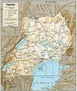
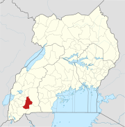
Bushenyi is a town in Western Uganda. It is the 'chief town' of Bushenyi District and the district headquarters are located there. The district is named after the town, in keeping with the practice in most of the districts in the country.

The Mbarara Northern Bypass Road is a road that bypasses the northern part of Mbarara City.

The Mukono–Kyetume–Katosi–Nyenga Road is a road in the Central Region of Uganda, connecting the towns of Mukono, Kyetume and Katosi in Mukono District to Nkokonjeru and Nyenga in Buikwe District.

Sanga Town in Western Region, Uganda

Sanga Town, also known as Sanga, is an urban center in the Kiruhura District, Ankole sub-region, in the Western Region of Uganda.

The Ishaka–Kagamba Road is a road in the Western Region of Uganda, connecting the town of Kagamba in Ntungamo District with Ishaka in Bushenyi District.

Kabale–Kisoro–Bunagana Road is a road in Western Uganda, connecting the towns of Kabale with the towns of Kisoro, Bunagana, at the border with the Democratic Republic of the Congo and Kyanika at the border with Rwanda.

The Nyakahita–Kazo–Kamwenge–Fort Portal Road is a road in the Western Region of Uganda, connecting the towns of Nyakahita and Kazo in Kiruhura District, Ibanda in Ibanda District, Kamwenge in Kamwenge District, and Fort Portal in Kabarole District.

Kazo, Uganda Place

Kazo is a town in the Western Region of Uganda.

The Kyenjojo–Kabwoya Road, in the Western Region of Uganda, connects the town of Kyenjojo in the Kyenjojo District with Kabwoya in the Hoima District. The road is part of the 238 kilometres (148 mi) Kyenjojo–Hoima–Masindi–Kigumba road corridor.

Tororo–Mbale–Soroti Road is a road in Eastern Uganda, connecting the towns of Tororo in Tororo District to Mbale in Mbale District and Soroti in Soroti District.

The Soroti–Dokolo–Lira Road is a road in Uganda, connecting the towns of Soroti in Soroti District, Dokolo in Dokolo District, and Lira in Lira District.

Ntungamo–Rukungiri Road is in the Western Region of Uganda, connecting the towns of Ntungamo in Ntungamo District with Rukungiri in Rukungiri District.

The Kampala–Mpigi Expressway, also Busega–Mpigi Expressway, is a proposed four-lane, dual carriage highway in the Central Region of Uganda, connecting, Kampala, the capital city, and Mpigi, the headquarters of Mpigi District.

Letshego Microfinance Uganda,, whose official name is Letshego Uganda Limited, is a Tier IV microfinance institution in Uganda.

Rukiga District is a district in Western Uganda. Its capital is Mparo. However, the largest urban center in the district is Muhanga.

Muhanga, Rukiga Place in Western Uganda, Uganda

Muhanga is a town in the Western Region of Uganda. It is the main commercial centre and largest town of Rukiga District. However, the district headquarters are located at Mparo.

References

  1. 1 2 3 Faridah Kulabako, and John Njoroge (30 December 2010). "Mbarara-Katuna Road Gets UShs325 Billion". Daily Monitor . Kampala. Retrieved 29 August 2015.
  2. UBOS (27 August 2014). "The Population of The Regions of the Republic of Uganda And All Cities And Towns of More Than 15,000 Inhabitants". Citypopulation.de Quoting Uganda Bureau of Statistics (UBOS). Retrieved 29 August 2015.
  3. Google (29 August 2015). "Location of Mbarara–Ntungamo–Kabale–Katuna Road At Google Maps" (Map). Google Maps . Google. Retrieved 29 August 2015.
  4. Maseruka, Josephine (2 January 2012). "Corruption Cited In Mbarara-Katuna Road Reconstruction". New Vision . Kampala. Retrieved 30 August 2015.
  5. URSO (January 2012). "Ongoing Major Projects". Ugandaroadsector.org (URSO). Retrieved 30 August 2015.
  6. Gilbert Kidimu (30 August 2016). "UNRA's Eight-Year Journey". New Vision . Kampala. Retrieved 12 March 2019.
  7. Ampurire, Paul (30 May 2018). "3 Years Later: Inside UNRA's Transformative Journey To Build An Efficient Entity". Kampala: SoftPower Uganda. Retrieved 12 March 2019.

Coordinates: 0°54′10″S30°15′14″E / 0.90278°S 30.25389°E / -0.90278; 30.25389

Geographic coordinate system Coordinate system

A geographic coordinate system is a coordinate system that enables every location on Earth to be specified by a set of numbers, letters or symbols. The coordinates are often chosen such that one of the numbers represents a vertical position and two or three of the numbers represent a horizontal position; alternatively, a geographic position may be expressed in a combined three-dimensional Cartesian vector. A common choice of coordinates is latitude, longitude and elevation. To specify a location on a plane requires a map projection.