
Delaware is a state in the Mid-Atlantic region of the United States, bordering Maryland to its south and west; Pennsylvania to its north; and New Jersey and the Atlantic Ocean to its east. The state takes its name from the nearby Delaware River named after Thomas West, 3rd Baron De La Warr, an English nobleman and Virginia's first colonial governor.

Little Creek is a town in Kent County, Delaware, United States. It is part of the Dover, Delaware Metropolitan Statistical Area. The population was 224 at the 2010 census.
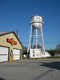
Magnolia is a town in Kent County, Delaware, United States. It is part of the Dover, Delaware Metropolitan Statistical Area. Recent estimates put the population at around 235, however, the population was 225 at the 2010 census.
Claymont is a census-designated place (CDP) in New Castle County, Delaware, United States. The estimated 2017 population of the 19703 ZIP code, which Claymont encompasses, was 15,292.

Hockessin is a census-designated place (CDP) in New Castle County, Delaware, United States. The population was 13,527 at the 2010 census.
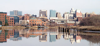
Wilmington is the largest and most populous city in the U.S. state of Delaware. The city was built on the site of Fort Christina, the first Swedish settlement in North America. It lies at the confluence of the Christina River and Brandywine River, near where the Christina flows into the Delaware River. It is the county seat of New Castle County and one of the major cities in the Delaware Valley metropolitan area. Wilmington was named by Proprietor Thomas Penn after his friend Spencer Compton, Earl of Wilmington, who was prime minister during the reign of George II of Great Britain.

Wappinger, officially the Town of Wappinger, is a town in Dutchess County, New York, United States. The town is located in the Hudson River Valley region, approximately 60 miles (97 km) north of Midtown Manhattan, on the eastern bank of the Hudson River. The population was 27,048 at the 2010 census. The name is derived from the Wappinger Native Americans who inhabited the area. Wappinger comprises three-fourths of the incorporated Village of Wappingers Falls, several unincorporated hamlets such as Chelsea, Diddell, Hughsonville, Middlebush, Myers Corners, New Hackensack, and Swartwoutville, and a number of neighborhoods.

Concord Township is a township in Delaware County, Pennsylvania, United States. The population was 17,231 at the 2010 census. It contains the unincorporated communities of Concordville and Glen Mills.
Newtown Township is a township in Delaware County, Pennsylvania, United States. Prior to 1789 it was part of Chester County. The population was 12,216 as of the 2010 census, and was 19,705 as of 2017.
Springfield Township, or simply Springfield, is a township in Delaware County in the U.S. state of Pennsylvania. The population was 24,211 at the 2010 census. Springfield is a suburb of Philadelphia, located about 10 miles (16 km) west of the city.

Radnor Township, often called simply Radnor, is a first class township with home rule status in Delaware County, Pennsylvania, United States. As of the 2019 United States census estimate, the township population is 31,875. Radnor Township is the largest municipality in Delaware County by land area and the fourth-largest by population, following Upper Darby Township, Haverford Township, and Chester.

The Delaware Valley is the valley through which the Delaware River flows. By extension, this toponym is commonly used to refer to Greater Philadelphia or the Philadelphia metropolitan area. The Delaware Valley is coterminous with a metropolitan statistical area (MSA) and broader combined statistical area (CSA), and is composed of counties located in Southeastern Pennsylvania, South Jersey, Delaware, and the Eastern Shore of Maryland. As of the 2010 Census, the MSA has a population of over 6 million, while the CSA has a population of over 7.1 million.
U.S. Route 113 (US 113) is a spur of US 13 in the U.S. states of Maryland and Delaware. The U.S. Highway runs 74.75 miles (120.30 km) from US 13 in Pocomoke City, Maryland north to Delaware Route 1 (DE 1) in Milford, Delaware. In conjunction with DE 1, US 113 is one of two major north–south highways on the Delmarva Peninsula that connect Dover with Pocomoke City and the Eastern Shore of Virginia. The U.S. Highway is the primary north–south highway in Worcester County, Maryland, where it connects Pocomoke City with Snow Hill and Berlin. US 113 is one of three major north–south highways in Sussex County, Delaware, where it connects Selbyville, Millsboro, and Georgetown with Milford. While US 113 does not pass through Ocean City or the Delaware Beaches, the U.S. Highway intersects several highways that serve the Atlantic seaboard resorts, including US 50, Maryland Route 90 (MD 90), US 9, DE 404, and DE 1. US 113 is a four-lane divided highway for its whole length.

Centerville is an unincorporated community in New Castle County, Delaware, United States. Centerville is now known primarily for being the location of Du Pont family estates, as well as several other wealthy business families from nearby Wilmington, and the home of Governor Jack Markell.
Windsor Hills is an unincorporated community in New Castle County, Delaware, United States. Windsor Hills is located north of the intersection of Delaware Route 261 and Shipley Road to the northeast of Wilmington.
Forest Hills Park is an unincorporated community in New Castle County, Delaware, United States. Forest Hills Park is located west of Shipley Road to the south of Wilson Road north of Wilmington.
Quaker Hill is an unincorporated community in New Castle County, Delaware, United States. Quaker Hill is located along Meeting House Road north of Old Wilmington Road to the north of Hockessin.
Stanton is an unincorporated community in New Castle County, Delaware, United States, near the confluence of the Red Clay and White Clay Creeks. It is located in the southern end of Mill Creek Hundred.

Star Hill is an unincorporated community in Kent County, Delaware, United States. Star Hill is located at the intersection of U.S. Route 13 and Voshells Mill Road/Voshells Mill Star Hill Road south of Camden.


