
Death Valley National Park is an American national park that straddles the California–Nevada border, east of the Sierra Nevada. The park boundaries include Death Valley, the northern section of Panamint Valley, the southern section of Eureka Valley and most of Saline Valley. The park occupies an interface zone between the arid Great Basin and Mojave deserts, protecting the northwest corner of the Mojave Desert and its diverse environment of salt-flats, sand dunes, badlands, valleys, canyons and mountains. Death Valley is the largest national park in the contiguous United States, as well as the hottest, driest and lowest of all the national parks in the United States. It contains Badwater Basin, the second-lowest point in the Western Hemisphere at 282 feet (86 m) below sea level. More than 93% of the park is a designated wilderness area. The park is home to many species of plants and animals that have adapted to this harsh desert environment including creosote bush, Joshua tree, bighorn sheep, coyote, and the Death Valley pupfish, a survivor from much wetter times. UNESCO included Death Valley as the principal feature of its Mojave and Colorado Deserts Biosphere Reserve in 1984.
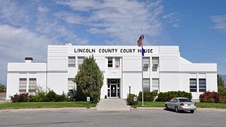
Lincoln County is a county located in the U.S. state of Nevada. As of the 2010 census, the population was 5,345. Its county seat is Pioche. Like many counties in Nevada, it is dry and sparsely populated, though notable for containing the Area 51 government Air Force base.
Valley Springs is a census-designated place (CDP) in Calaveras County, California, United States, in the foothills of the Sierra Nevada Mountain Range. Valley Springs is registered as a California Historical Landmark, number 251.

Bear Valley Springs is a guarded-gate community in Kern County, California, United States. Bear Valley Springs is in the Tehachapi Mountains and is part of the greater Tehachapi area. The elevation ranges from 4,121 feet (1,256 m) to 6,934 feet (2,113 m). The population fluctuates between a low during the winter months when snow is common, to a high in the summer months when its elevation keeps it much cooler than surrounding areas and major cities. The population was 5,172 at the 2010 census, up from 4,232 at the 2000 census. For statistical purposes, the United States Census Bureau has defined Bear Valley Springs as a census-designated place (CDP). The census definition of the area may not precisely correspond to local understanding of the area with the same name.

Moreno Valley is a city in Riverside County, California and is part of the Riverside-San Bernardino-Ontario Metropolitan Area. It is the second-largest city in Riverside County by population and one of the Inland Empire's population centers. As of the 2010 census, the city's population was 193,365. Moreno Valley is also part of the larger Greater Los Angeles area.

Yucca Valley is an incorporated town in San Bernardino County, California, United States. The population was 20,700 as of the 2010 census. Yucca Valley lies 17 miles (27 km) west of Twentynine Palms, 27 miles (43 km) north of Palm Springs, 62 miles (100 km) south of Barstow via State Route 247 and 55 miles (89 km) east of San Bernardino.

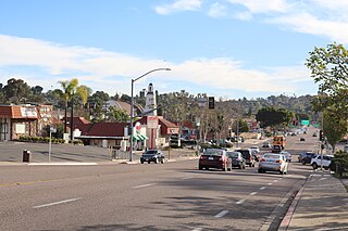
Spring Valley is a census-designated place (CDP) in the East County region of San Diego County, California. The population was 28,205 at the 2010 census.

Spring Valley is a city situated on the Illinois River in Bureau County, Illinois, United States. The population was 5,398 at the 2000 census, and 5,558 in 2010. It is part of the Ottawa Micropolitan Statistical Area.

Spring Valley is a home rule-class city in Jefferson County, Kentucky, United States. The population was 654 at the 2010 census.

Spring Valley is a city in Fillmore County, Minnesota, United States. The population was 2,479 at the 2010 census.

Spring Valley is an unincorporated town and census-designated place in Clark County, Nevada, United States, located 2 miles (3 km) west of the Las Vegas Strip. The population was 178,395 at the 2010 census. Spring Valley was formed in May 1981.

Spring Valley is a suburb of New York City, a village in the towns of Ramapo and Clarkstown in Rockland County, New York, United States. It is located north of Chestnut Ridge, east of Airmont and Monsey, south of Hillcrest, and west of Nanuet. The population was 31,347 at the 2010 census, making it the 2nd most populous community in Rockland County, after New City.

Spring Valley Village is a city in Harris County, Texas, United States, and an enclave of Houston. The population was 3,715 at the 2010 U.S. census and 4,319 at the 2019 American Community Survey.

The Coachella Valley is an arid rift valley in the Colorado Desert of Southern California's Riverside County. The valley extends approximately 45 mi (72 km) southeast from the San Gorgonio Pass to the northern shore of the Salton Sea and the neighboring Imperial Valley, and is approximately 15 mi (24 km) wide along most of its length. It is bounded on the northeast by the San Bernardino and Little San Bernardino Mountains, and on the southwest by the San Jacinto and Santa Rosa Mountains.
Casa de Oro is a neighborhood in east San Diego County, California, United States. The community, twelve miles east of San Diego, is in the unincorporated town of Spring Valley and an unincorporated part of La Mesa. The United States Census Bureau has also divided the neighborhood between two census-designated places (CDPs), Spring Valley CDP and Casa de Oro-Mount Helix CDP. Casa de Oro's main thoroughfare is Campo Road.

The Reno–Sparks Metropolitan Statistical Area, as defined by the United States Census Bureau, is an area consisting of two counties in Western Nevada, anchored by the cities of Reno and Sparks, part of Greater Reno-Tahoe-Fernley CSA. As of the 2010 census, the MSA had a population of 425,417.

Ricks Spring is a karst spring, a natural water outflow from a cave in Logan Canyon within the Wasatch-Cache National Forest in northeast Utah. The spring is not an artesian source, but comes from the Logan River. Ricks Spring is the most well known of several springs in an underground water network of the area.

Coachella Valley National Wildlife Refuge is a 3,709-acre (15.01 km2) protected area in the Coachella Valley, located east of Palm Springs near Palm Desert, California. The refuge contains the majority of critical habitat for the Coachella Valley Fringe-toed Lizard within the Coachella Valley Preserve and Indio Hills Palms State Reserve.

Riverside County is a county located in the southern portion of the U.S. state of California. As of the 2010 census, the population was 2,189,641, making it the fourth-most populous county in California and the 10th-most populous in the United States. The name was derived from the city of Riverside, which is the county seat.

Spring Valley is an unincorporated community located within Marlboro Township in Monmouth County, New Jersey, United States. Located in the northern section of the township, the area is mainly forested with some businesses and cemeteries lining the main roads in the area, Spring Valley Road and Texas Road. U.S. Route 9, Route 18 and County Route 3 are major roads nearby Spring Valley.


