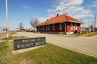
Walnut Ridge is a city in Lawrence County, Arkansas, United States. The population was 5098 at the 2019 census. The city is the county seat of Lawrence County. Walnut Ridge lies immediately north of Hoxie. The two towns form a contiguous urban area with approximately 8,000 residents. Williams Baptist University is in College City, a formerly separate community that merged into Walnut Ridge in 2017.

Walnut Creek is a city in Contra Costa County, California, United States, located in the East Bay region of the San Francisco Bay Area, about 16 miles (26 km) east of the city of Oakland. With a total estimated population of 70,166, Walnut Creek serves as a hub for its neighboring cities because of its location at the junction of the highways from Sacramento and San Jose (I-680) and San Francisco/Oakland (SR-24) and its accessibility by BART. Its active downtown neighborhood features hundred-year-old buildings and extensive high-end retail establishments.
Magnolia is a town in Kent County, Delaware, United States. It is part of the Dover, Delaware Metropolitan Statistical Area. Recent estimates put the population at around 235, however, the population was 225 at the 2010 census.

Walnut Hill is a village in Marion County, Illinois, United States. The population was 109 at the 2000 census.

The Delaware Water Gap is a water gap on the border of the U.S. states of New Jersey and Pennsylvania where the Delaware River cuts through a large ridge of the Appalachian Mountains. The gap constitutes the southern portion of the Delaware Water Gap National Recreation Area, which is used primarily for recreational purposes, such as rafting, canoeing, swimming, fishing, hiking, and rock climbing.
Walnut Ridge may refer to the following places in the United States:

A water gap is a gap that flowing water has carved through a mountain range or mountain ridge and that still carries water today. Such gaps that no longer carry water currents are called wind gaps. Water gaps and wind gaps often offer a practical route for road and rail transport to cross the mountain barrier.

Kittatinny Mountain is a long ridge traversing across northwestern New Jersey running in a northeast-southwest axis, a continuation across the Delaware Water Gap of Pennsylvania's Blue Mountain Ridge. It is the first major ridge in the far northeastern extension of the Ridge and Valley province of the Appalachian Mountains, and reaches its highest elevation, 1,803 feet, at High Point in Montague Township. Kittatinny Mountain forms the eastern side of Wallpack Valley; the western side comprises the Wallpack Ridge (highest elevation: 928 feet above sea level.

Blue Mountain, Blue Mountain Ridge, or the Blue Mountains of Pennsylvania is a ridge of the Appalachian Mountains in the U.S. state of Pennsylvania. Forming the southern and eastern edge of the Ridge-and-Valley Appalachians physiographic province in Pennsylvania, Blue Mountain extends 150 miles (240 km) from the Delaware Water Gap on the New Jersey border in the east to Big Gap in Franklin County, south-central Pennsylvania, at its southwestern end.

Bridesburg, the northernmost of Philadelphia's River Wards, is a river-front neighborhood in the Northeast section of Philadelphia, Pennsylvania, United States. Bridesburg is an historically German and Irish community, with a significant community of Polish immigrants who arrived mostly in the early- to mid-twentieth century. The community is home to two Catholic churches: All Saints Church, designed by Edwin Forrest Durang, built in 1889; and Saint John Cantius Church, built some time after 1892 in Polish Cathedral style.

Arkansas Highway 25 is a northeast–southwouthwest state highway in north central Arkansas. The route runs 85.66 miles (137.86 km) from US 64 in Conway to US 63/412 in Black Rock through Greers Ferry, Batesville, and the foothills of The Ozarks.

Genoa Township is one of the eighteen townships of Delaware County, Ohio, United States. Genoa Township boasts scenic open spaces including two recreational reservoirs, excellent service including its own police and fire departments, high quality schools, and proximity to job and entertainment centers.
U.S. Route 13 Business is an 8.19-mile (13.18 km) business route of US 13 that runs through the heart of the city of Wilmington in New Castle County, Delaware, where US 13 bypasses downtown Wilmington to the east, running near Interstate 495 (I-495) and the Delaware River. US 13 Bus. begins at I-495 and US 13 at the southern border of Wilmington and heads north toward the downtown area, where it splits into a one-way pair. Past downtown, the business route heads through the northeastern part of the city on North Market Street before continuing through suburban Brandywine Hundred on Philadelphia Pike. US 13 Bus. reaches its northern terminus at US 13 in Claymont. US 13 Bus. is a four-lane road for much of its length.
U.S. Route 11 (US 11) roughly parallels Interstate 81 (I-81) in the U.S. state of Pennsylvania. It serves Harrisburg and Scranton. Between those two cities, US 11 follows the Susquehanna River, while I-81 follows a shorter route over the mountains.
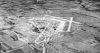
Marine Corps Air Facility Walnut Ridge is a former United States Army and United States Marine Corps airfield located in Walnut Ridge, Arkansas. After it was closed, it was redeveloped into Walnut Ridge Regional Airport.

Naaman is an unincorporated community in New Castle County, Delaware, United States. Naaman is located at the intersection of Delaware Route 92 and Ridge Road northeast of Claymont.

Walnut Ridge Air Force Station is a closed United States Air Force General Surveillance Radar station. It is located 4.7 miles (7.6 km) north-northeast of Walnut Ridge, Arkansas. It was closed in 1963.

Sandy Ridge is an unincorporated community located within Delaware Township in Hunterdon County, New Jersey, United States. As its name implies, the community is located at the top of a small hill that is sandwiched between the Hunterdon Plateau and the Sourland Mountains. Sandy Ridge Road is the main road east and west through the community while County Route 605 is a minor arterial road that passes north and south through the area. CR 605 enters from the south on Sandy Ridge-Mt. Airy Road, jogs to the west on Sandy Ridge Road for 0.04 miles (64 m), and exits to the north on Cemetery Road towards CR 523. The area consists of mainly residences with some farmland and forestland. The Sandy Ridge Church is a Baptist church founded in 1818 with its current building constructed in 1866 and is located in the center of Sandy Ridge.


