
Dover is the capital and second-largest city in the U.S. state of Delaware. It is also the county seat of Kent County, and the principal city of the Dover, DE Metropolitan Statistical Area, which encompasses all of Kent County and is part of the Philadelphia-Wilmington-Camden, PA-NJ-DE-MD Combined Statistical Area. It is located on the St. Jones River in the Delaware River coastal plain. It was named by William Penn of Dover in Kent, England. As of 2010, the city had a population of 36,047.

Camden is a town in Kent County, Delaware, United States. It is part of the Dover, Delaware Metropolitan Statistical Area. The population was 3,464 at the 2010 census.
Milford is a city in Kent and Sussex counties in the U.S. state of Delaware. According to the 2010 census, the population of the city is 9,559.
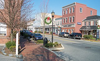
Smyrna is a town in Kent and New Castle counties in the U.S. state of Delaware. It is part of the Dover, Delaware Metropolitan Statistical Area. According to the Census Bureau, as of 2010, the population of the town is 10,023.

Hockessin is a census-designated place (CDP) in New Castle County, Delaware, United States. The population was 13,527 at the 2010 census. The place name may be derived from the Lenape word "hòkèsa" meaning "pieces of bark" or from a misspelling of "occasion," as pronounced by the Quakers who settled the area originally.

New Castle is a city in New Castle County, Delaware, six miles (10 km) south of Wilmington, situated on the Delaware River. According to the 2010 Census, the population of the city is 5,285.

The Delaware Valley is the valley through which the Delaware River flows. By extension, this toponym is commonly used to refer to Greater Philadelphia or Philadelphia metropolitan area, which straddles the Lower Delaware River just north of its estuary. The Delaware Valley Metropolitan Area is located at the southern part of the Northeast megalopolis and as such, the Delaware Valley can be described as either a metropolitan statistical area (MSA), or as a broader combined statistical area (CSA). The Delaware Valley Metropolitan Area is composed of several counties in southeastern Pennsylvania and southwestern New Jersey, one county in northern Delaware, and one county in northeastern Maryland. The MSA has a population of over 6 million, while the CSA has a population of over 7.1 million. Philadelphia, being the region's major commercial, cultural, and industrial center, wields a rather large sphere of influence that affects the counties that immediately surround it.
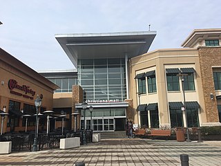
The Christiana Mall is a super-regional shopping mall located between the cities of Newark and Wilmington, Delaware, United States. The mall is situated at the intersection of Interstate 95 and Delaware Route 1, near the Cavaliers Country Club, and close to the center of the Northeast megalopolis.

Northwood is an unincorporated community in New Castle County, Delaware, United States.

Kirkwood is an unincorporated community in central New Castle County, Delaware, United States. It lies along Delaware Route 71, southwest of the city of Wilmington, the county seat of New Castle County. Its elevation is 69 feet (21 m). Although it is unincorporated, it has a post office, with the ZIP code of 19708.
Hanbys Corner is an unincorporated community in New Castle County, Delaware, United States. It is located at the intersection of Delaware Route 3 and Delaware Route 92, in Brandywine Hundred. The area is named for Richard G. Hanby, who first purchased the 125-acre (0.51 km2) parcel from the descendants of William Penn in 1753. His descendants included several notable figures in the local political scene including Samuel Winfield Hanby (1817-1892) who was elected as a State Representative in 1874, Jacob Klose Hanby (1839-1932) who was Samuel's son and was elected State Representative in 1904, Robert Johnson Hanby (1834-1898), who served in the 124th PA infantry during the Civil War and was elected State Senator in 1896, and Florence Wood Hanby (1870-1963), who was Robert's daughter-in-law and was the first woman elected to the Delaware House of Representatives in 1924. In addition Wayne Hanby and James Hanby have both served as Justices of the Peace for New Castle County. The last Hanby to occupy the property, Albert T. Hanby (1881-1947), another son of Samuel, attended West Chester State College before getting his law degree from Penn Law School. Albert became a Philadelphia lawyer and left his farm at Hanby's Corner to be used for the good of "all the children in Delaware". He and his wife created a foundation in 1945 to protect the property from further development. Today the YMCA operates their Hanby Camp there, and the trust provide scholarships for kids who might not otherwise be able to attend. In 2007 that support was over $70,000.
Webster Farm is an unincorporated community in New Castle County, Delaware, United States. Webster Farm is located southwest of the intersection of Delaware Route 3 and Wilson Road northeast of Wilmington.
West Farm is an unincorporated community in New Castle County, Delaware, United States. West Farm is located southeast of the intersection of Delaware Route 52 and Kirk Road north of Greenville.
Blue Ball is an unincorporated community in New Castle County, Delaware, United States. Blue Ball is located at the junction of U.S. Route 202, Delaware Route 141, and Delaware Route 261 north of Wilmington.
Sedgley Farms is an unincorporated community in New Castle County, Delaware, United States. Sedgley Farms is located along Centerville Road north of Delaware Route 48 to the west of Wilmington.
Stanton is an unincorporated community in New Castle County, Delaware, United States, near the confluence of the Red Clay and White Clay Creeks. It is located in the southern end of Mill Creek Hundred.
Sandtown is an unincorporated community in Kent County, Delaware, United States. Sandtown is located on Delaware Route 10 just east of the Maryland border.

Westgate is a neighborhood in the Southwest District of Baltimore, located between Baltimore County (west) and the city neighborhood of Ten Hills (east). Its boundaries are marked by Baltimore National Pike (north), Frederick Avenue (south), Rock Glen Avenue and Edmondson Avenue (east) and the city line (west).
Hollandsville is an unincorporated community in Kent County, Delaware, United States. Hollandsville is located at the intersection of Delaware Route 12 and Spectrum Farms Road/Hills Market Road west of Felton.


