
Cheswold is a town in Kent County in the U.S. state of Delaware. It is part of the Dover, Delaware Metropolitan Statistical Area. The population was 1,380 at the 2010 census.

Clayton is a town in Kent and New Castle counties in the U.S. state of Delaware. Located almost entirely in Kent County, it is part of the Dover, Delaware Metropolitan Statistical Area. The population was 2,918 at the 2010 census.
Farmington is a town in Kent County, Delaware, United States. It is part of the Dover, Delaware Metropolitan Statistical Area. The population was 110 at the 2010 census.

Felton is a town in Kent County, Delaware, United States. It is part of the Dover, Delaware Metropolitan Statistical Area. The population was 1,298 at the 2010 census.
Harrington is a city in Kent County, Delaware, United States. It is part of the Dover, Delaware Metropolitan Statistical Area. Harrington hosts the annual Delaware State Fair each July. The population was 3,562 at the 2010 census.

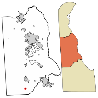
Houston is a town in Kent County, Delaware, United States. It is part of the Dover, Delaware Metropolitan Statistical Area. The population was 374 at the 2010 census. It was named for John W. Houston.

Viola is a town in Kent County, Delaware, United States. It is part of the Dover, Delaware Metropolitan Statistical Area. The population was 157 at the 2010 census.

Woodside is a town in Kent County, Delaware, United States. It is part of the Dover, Delaware Metropolitan Statistical Area. The population was 181 at the 2010 census.

Wyoming is a town in Kent County, Delaware, United States. It was named after the Wyoming Valley in Pennsylvania. It is part of the Dover, Delaware, Metropolitan Statistical Area. The population was 1,313 at the 2010 census.

Townsend is a town in New Castle County, Delaware, United States. The population was 2,049 at the 2010 census, an increase of 492.2% from 2000. The center of population of Delaware is located in Townsend.

Delaware Route 404 (DE 404) is a major state highway in Sussex County, Delaware that spans the width of the state. DE 404's western terminus is at the Maryland border northwest of Bridgeville, where the road continues into that state as Maryland Route 404 (MD 404), and its eastern terminus is at the Five Points intersection with U.S. Route 9 (US 9), DE 1, and US 9 Business. The route passes through rural areas as well as the towns of Bridgeville and Georgetown. DE 404 runs concurrent with DE 18 from east of Bridgeville to Georgetown and with US 9 from Georgetown to Five Points. DE 404 has a business route, DE 404 Bus., that passes through Bridgeville and a truck route, DE 404 Truck, that bypasses Georgetown. DE 404, along with MD 404, serves as a major route connecting the Chesapeake Bay Bridge and the Baltimore–Washington Metropolitan Area with the Delaware Beaches.
Delaware Route 16 (DE 16) is an east-west state highway in Delaware, mainly across northern Sussex County, with a small portion near the Maryland border in extreme southwestern Kent County. It runs from Maryland Route 16 (MD 16) at the Maryland border in Hickman to the Delaware Bay at Broadkill Beach. The route runs through rural areas, passing through the towns of Greenwood, Ellendale, and Milton. DE 16 intersects U.S. Route 13 (US 13) and DE 36 in Greenwood, US 113 in Ellendale, DE 30 and DE 5 in the Milton area, and DE 1 between Milton and Broadkill Beach. West of DE 1, the route serves as part of a connection between the Baltimore–Washington Metropolitan Area and the Delaware Beaches. DE 16 was built as a state highway during the 1920s and 1930s. By 1936, the route was designated onto its current alignment.

Delaware Route 20 (DE 20) is an east–west state highway in Sussex County, Delaware. Its western terminus is the Maryland state line in Reliance, where it continues as Maryland Route 392 (MD 392). Its eastern terminus is DE 54 west of Fenwick Island. The route runs through rural areas of Sussex County and passes through the towns of Seaford, Millsboro, and Dagsboro. DE 20 intersects U.S. Route 13 (US 13) in Seaford, US 9 in Hardscrabble, US 113 and DE 24/DE 30 in Millsboro, DE 26 in Dagsboro, and DE 17 in Roxana. DE 20 was originally created by 1936 to run from the Maryland border east to US 113 in Millsboro. By 1970, it was realigned to bypass Seaford. The route was extended east to DE 1 in Fenwick Island by 1994; however, the eastern terminus was cut back to DE 54 in 2005 to avoid the concurrency with that route.

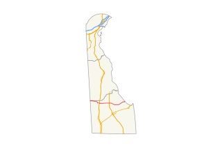
Delaware Route 10 (DE 10) is a state highway in Kent County, Delaware. It runs from Maryland Route 287 (MD 287) at the Maryland border in Sandtown east to an interchange with DE 1 at the North Gate of Dover Air Force Base in the southeastern part of the city of Dover. The route passes through the towns of Camden and Wyoming along the way. From the Maryland border to Camden, it is a two-lane undivided road that passes through rural areas. DE 10 is a four-lane divided highway called Lebanon Road between U.S. Route 13 (US 13) in Camden and DE 1. DE 10 has one alternate route, DE 10 Alternate, which provides an alternate alignment between Willow Grove and Highland Acres, passing through Woodside and Rising Sun.

Delaware Route 24 (DE 24) is a state highway located in Sussex County, Delaware. The route runs east from Maryland Route 348 (MD 348) at the Maryland border east of Sharptown, Maryland to an intersection with DE 1 in Midway, between Lewes and Rehoboth Beach. Along the way, DE 24 passes through Laurel, Millsboro, and Long Neck. DE 24 intersects U.S. Route 13 (US 13) in Laurel, US 113/DE 20 in Millsboro, and DE 5 and DE 23 in Long Neck. The route runs concurrent with DE 30 between Mission and Millsboro. DE 24 features an alternate alignment, DE 24 Alternate, that runs to the north of the route from US 113 in Stockley to DE 24 near Midway. DE 24 was built as a state highway throughout the 1920s, with completion of the entire route by 1931. DE 24 was assigned onto its current alignment by 1936. DE 24 Alt. was designated by 2006.

Delaware Route 5 (DE 5) is a 19.49-mile-long (31.37 km) state highway in Sussex County, Delaware. The route runs from River Road and Oak Orchard Avenue on the Indian River Bay in Oak Orchard north to DE 1, north of Milton. Along the way, DE 5 passes through rural areas along with the communities of Long Neck, Harbeson, and Milton. The route has concurrencies with DE 23 and DE 24 in the Long Neck area and crosses U.S. Route 9 (US 9)/DE 404 in Harbeson and DE 16 in Milton. DE 5 features one alternate route, DE 5 Alternate, which provides a bypass of Milton. DE 5 was built as a state highway in the 1920s and 1930s. The road between Long Neck and north of Milton, including present-day DE 5 north of DE 24, was designated as part of a short-lived DE 22 in the 1930s. DE 5 was designated to its current alignment by 1938. DE 5 Alt. was designated by 2001.

Delaware Route 30 (DE 30) is a state highway in Sussex County, Delaware. The route runs from an intersection with Bi-State Boulevard a short distance west of U.S. Route 13 (US 13) between Laurel and Delmar to DE 1 Business southeast of Milford in the area of Lincoln and Cedar Creek. The road runs east to Gumboro, where it turns north on the Millsboro Highway to Millsboro. Along this road, DE 30 shares concurrencies with DE 26, DE 54, and DE 24. From Millsboro, the route passes through Gravel Hill and to the west of Milton before reaching Milford. DE 30 is signed as an east-west road from the southern terminus to the east end of the DE 24 concurrency in Millsboro and as a north-south road from that point until the northern terminus.

Delaware Route 71 (DE 71) is a state highway in New Castle County, Delaware. The route loops off U.S. Route 13 (US 13) from south of Townsend to Tybouts Corner, traveling to the west of US 13 by way of Townsend, Middletown, and the Summit Bridge. The route overlaps DE 896 from Mount Pleasant to just north of the Summit Bridge, where DE 896 continues north to Glasgow.
The Delmarva Central Railroad is an American short-line railroad owned by Carload Express that operates 188 miles (303 km) of track on the Delmarva Peninsula in the states of Delaware, Maryland, and Virginia. The railroad operates lines from Porter, Delaware to Hallwood, Virginia and from Harrington, Delaware to Frankford, Delaware along with several smaller branches. The DCR interchanges with the Norfolk Southern Railway and the Maryland and Delaware Railroad. The railroad was created in 2016 to take over the Norfolk Southern Railway lines on the Delmarva Peninsula. The DCR expanded by taking over part of the Bay Coast Railroad in 2018 and the Delaware Coast Line Railroad in 2019.

The Delaware Railroad was the major railroad in the US state of Delaware, traversing almost the entire state north to south. It was planned in 1836 and built in the 1850s. It began in Porter and was extended south through Dover, Seaford and finally reached Delmar on the border of Maryland in 1859. Although operated independently, in 1857 it was leased by and under the financial control of the Philadelphia, Wilmington, and Baltimore Railroad. In 1891, it was extended north approximately 14 miles (23 km) with the purchase of existing track to New Castle and Wilmington. With this additional track, the total length was 95.2 miles (153.2 km).


