State Road, Delaware

Last updated
State Road, Delaware
US 13 SB-US 40 WB at split in State Road.jpeg
Split between US 13 and US 40 in State Road
USA Delaware location map.svg
Red pog.svg
State Road
Usa edcp location map.svg
Red pog.svg
State Road
Coordinates: 39°39′2″N75°37′22″W / 39.65056°N 75.62278°W / 39.65056; -75.62278 Coordinates: 39°39′2″N75°37′22″W / 39.65056°N 75.62278°W / 39.65056; -75.62278
Country United States
State Delaware
County New Castle
Elevation
36 ft (11 m)
Time zone UTC-5 (Eastern (EST))
  Summer (DST) UTC-4 (EDT)
Area code(s) 302
GNIS feature ID214690 [1]

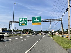
State Road is an unincorporated area in New Castle County, Delaware, United States. State Road is located at the intersection of U.S. Route 13 and U.S. Route 40, southwest of New Castle. [2]

For many years, State Road was the location of a major rest stop on the intercity bus network known as Clemente's Rest, which served buses traveling between the Northeastern United States, the Southern United States, and points on the Delmarva Peninsula. [3] [4] The rest stop billed itself as "the Place Where The Nation Meets and Eats". [5] It had opened in 1951 and closed in 1992, as Greyhound began moving its operations to its Wilmington agency. [6] The area earlier had a stop on the New York, Philadelphia and Norfolk Railroad. [7]

Related Research Articles

Claymont, Delaware CDP in Delaware, United States

Claymont is a census-designated place (CDP) in New Castle County, Delaware. The estimated 2017 population of the 19703 ZIP code, which Claymont encompasses, was 15,292.

<span class="mw-page-title-main">Newark, Delaware</span> City in New Castle County, Delaware, U.S.

Newark is a small city in New Castle County, Delaware, United States. It is located 12 miles (19 km) west-southwest of Wilmington. According to the 2010 Census, the population of the city is 31,454. Newark is home to the University of Delaware.

Newport, Delaware Town in Delaware, United States

Newport is a town in New Castle County, Delaware, United States. It is on the Christina River. It is best known for being the home of colonial inventor Oliver Evans. The population was 1,055 at the 2010 census. Four limited access highways, I-95, I-295, I-495, and Delaware Route 141 intersect within one mile (1.6 km) of the town.

Interstate 495 (Delaware) Highway in Delaware

Interstate 495 (I-495) is an 11.47-mile (18.46 km) long Interstate highway in the U.S. state of Delaware. The highway, named the Vietnam Veterans Memorial Highway, serves as a six-lane bypass of I-95 around the city of Wilmington. I-495 begins at an interchange with I-95 and I-295 near Newport to the southwest of Wilmington. From here, the road heads east to the Port of Wilmington, where it turns northeast and crosses the Christina River as it heads to the east of downtown Wilmington. Upon reaching Edgemoor, I-495 runs between the Delaware River to the east and U.S. Route 13 (US 13) to the west, continuing to Claymont. In Claymont, I-495 turns north and merges into northbound I-95 at an interchange with Delaware Route 92 (DE 92) just south of the Pennsylvania state line.

Wilmington station (Delaware) Passenger rail station in Wilmington, Delaware

The Joseph R. Biden, Jr., Railroad Station, also known as Wilmington station, is a passenger rail station in Wilmington, Delaware. One of Amtrak's busiest stops, it serves nine Amtrak train routes and is part of the Northeast Corridor. It also serves SEPTA Regional Rail commuter trains on the Wilmington/Newark Line as well as DART First State local buses and Greyhound Lines intercity buses.

DART First State Delawares public transport system operator

The Delaware Transit Corporation, operating as DART First State, is the only public transportation system that operates throughout the U.S. state of Delaware. DART First State provides local and inter-county bus service throughout the state and also subsidizes commuter rail service along SEPTA Regional Rail's Wilmington/Newark Line serving the northern part of the state. The agency also operates statewide paratransit service for people with disabilities. DART First State is a subsidiary of the Delaware Department of Transportation (DelDOT).

Interstate 95 in Delaware Section of Interstate Highway in New Castle County, Delaware, United States

Interstate 95 (I-95) is an Interstate highway running along the East Coast of the United States from Miami, Florida, north to the Canadian border in Houlton, Maine. In the state of Delaware, the route runs for 23.43 mi (37.71 km) across the Wilmington area in northern New Castle County from the Maryland state line near Newark northeast to the Pennsylvania state line in Claymont. I-95 is the only primary (2-digit) Interstate highway that enters Delaware, although it also has two auxiliary routes within the state. Between the Maryland state line and Newport, I-95 follows the Delaware Turnpike, a toll road with a mainline toll plaza near the state line. Near Newport, the Interstate has a large interchange with Delaware Route 141 (DE 141) and the southern termini of I-295 and I-495. I-95 heads north through Wilmington concurrent with U.S. Route 202 (US 202) on the Wilmington Expressway. Past Wilmington, I-95 continues northeast to Claymont, where I-495 rejoins the route right before the Pennsylvania state line.

Delaware Route 2 Sate highway in New Castle, Delaware, United States

Delaware Route 2 (DE 2) is a 10.81-mile-long (17.40 km) east–west state highway located in the northern part of New Castle County in the U.S. state of Delaware. It runs from DE 72 and DE 273 on the eastern edge of Newark east to DE 52 in Wilmington. Between Newark and Wilmington, the route is a four- to six-lane divided highway called Capitol Trail and Kirkwood Highway that passes through suburban areas, running through Marshallton, Prices Corner, and Elsmere. In Wilmington, DE 2 is routed along the one-way pair of Lincoln Street eastbound and Union Street westbound, passing through urban areas.

Delaware Route 896 State highway in New Castle County, Delaware, United States

Delaware Route 896 (DE 896) is a state highway located in New Castle County, Delaware. The route runs from U.S. Route 13 (US 13) in Boyds Corner north to the Maryland border northwest of Newark, where the road becomes unsigned Maryland Route 896 (MD 896) briefly before heading into Pennsylvania as Pennsylvania Route 896 (PA 896). The route heads west from US 13 before turning north along with DE 71 in Mount Pleasant, crossing the Chesapeake & Delaware Canal on the Summit Bridge. After the bridge, DE 71 splits off to the east and the road continues to Glasgow, where it comes to an intersection with US 40. DE 896 continues north and interchange with Interstate 95 (I-95) before reaching Newark, where it bypasses the University of Delaware to the west by following DE 4, Elkton Road, and South Main Street. DE 896 comes to downtown Newark and continues northwest to the Maryland border. DE 896 has a business route, DE 896 Business, that passes through Glasgow, and had an alternate alignment south of Glasgow called DE 896 Alternate.

Delaware Route 9 State highway in Kent and New Castle counties in Delaware, United States

Delaware Route 9 (DE 9) is a 57.83-mile (93.07 km) state highway that runs from DE 1 near Dover Air Force Base in Kent County north to DE 2 in the city of Wilmington in New Castle County. DE 9 is a designated scenic highway known as the Delaware Bayshore Byway south of New Castle, running through mostly rural areas to the west of the Delaware Bay and the Delaware River as a two-lane undivided road. Between New Castle and Wilmington, DE 9 is a four-lane road that runs through urban and suburban areas. DE 9 passes through several cities and towns including Little Creek, Leipsic, Port Penn, Delaware City, and New Castle. DE 9 has an auxiliary route, DE 9A, that provides access to the Port of Wilmington. In addition, it has a truck route, DE 9 Truck, located to the south of New Castle.

Delaware Route 48 State highway in New Castle County, Delaware, United States

Delaware Route 48 (DE 48) is a state highway in New Castle County, Delaware. The route runs from DE 41 in Hockessin east to U.S. Route 13 Business in downtown Wilmington. The route passes through suburban areas of Wilmington such as Lancaster Pike, intersecting DE 100 and DE 141. DE 48 continues into Wilmington as Lancaster Avenue and intersects DE 2, where it splits into the one-way pair of Lancaster Avenue eastbound and Second Street westbound. Upon reaching downtown Wilmington, the route intersects Interstate 95 (I-95)/US 202 and DE 4 before continuing to the eastern terminus.

Delaware Route 3 State highway in New Castle County, Delaware, United States

Delaware Route 3 (DE 3) is a state highway northeast of the city of Wilmington in New Castle County, Delaware. The route runs from an interchange at Interstate 495 (I-495) in Edgemoor north to DE 92 in Hanbys Corner. The route passes through the suburban areas of Brandywine Hundred, Bellefonte, and Arden. It intersects U.S. Route 13 (US 13) in Edgemoor, US 13 Business in Bellefonte, and I-95 near Bellevue State Park. DE 3 was built as a state highway during the 1920s and 1930s. By 1968, the route was designated between US 13 north to DE 92 on Marsh Road. The route was moved to its current alignment and terminus by 1984.

Delaware Route 202 State highway in Wilmington, Delaware, United States

Delaware Route 202 (DE 202), also known as Concord Avenue, is a short state highway in Wilmington, Delaware. It runs from U.S. Route 13 Business north to a modified cloverleaf interchange with Interstate 95 (I-95) and US 202 at the northern city limits. North of the interchange, the route becomes US 202 northbound, also known as the Concord Pike. The road is two lanes and undivided for most of its length except for the part just south of the I-95 interchange, which is four lanes and divided. DE 202 was a part of US 202 until that highway was truncated to the I-95 interchange in 1970. DE 202 was designated by 1981.

U.S. Route 13 Business (Wilmington, Delaware) Business route in Wilmington, Delaware

U.S. Route 13 Business is an 8.19-mile (13.18 km) business route of US 13 that runs through the heart of the city of Wilmington in New Castle County, Delaware, where US 13 bypasses downtown Wilmington to the east, running near Interstate 495 (I-495) and the Delaware River. US 13 Bus. begins at I-495 and US 13 at the southern border of Wilmington and heads north toward the downtown area, where it splits into a one-way pair. Past downtown, the business route heads through the northeastern part of the city on North Market Street before continuing through suburban Brandywine Hundred on Philadelphia Pike. US 13 Bus. reaches its northern terminus at US 13 in Claymont. US 13 Bus. is a four-lane road for much of its length.

U.S. Route 13 in Delaware Highway in Delaware

U.S. Route 13 (US 13) is a U.S. highway running from Fayetteville, North Carolina, north to Morrisville, Pennsylvania. In the U.S. state of Delaware, the route runs for 103.33 mi (166.29 km). It traverses the entire north–south length of the state from the Maryland state line in Delmar, Sussex County, north to the Pennsylvania state line in Claymont, New Castle County. US 13 connects many important cities and towns in Delaware, including Seaford, Dover, and Wilmington. The entire length of US 13 in Delaware is a multilane divided highway with the exceptions of the segment through Wilmington and parts of the route in Claymont. Between the Maryland state line and Dover, US 13 serves as one of the main north–south routes across the Delmarva Peninsula. From Dover north to Tybouts Corner, the route is followed by the controlled-access Delaware Route 1 (DE 1) toll road, which crosses the route multiple times and has multiple interchanges with it. US 13 bypasses downtown Wilmington to the east before it heads northeast of the city parallel to Interstate 495 (I-495) and the Delaware River to Claymont. US 13 is the longest numbered highway in the state of Delaware.

Special routes of U.S. Route 13

U.S. Route 13 runs along the Atlantic coastline for over 500 miles (800 km), passing through five states. Along its route, it possessed numerous special routes, which are all loops off the mainline US 13. At present, there are at least fifteen special routes in existence: two in North Carolina, five in Virginia, two in Maryland, four in Delaware, and two in Pennsylvania. Seven others have existed in the past, but have been deleted.

U.S. Route 202 in Delaware Highway in Delaware

U.S. Route 202 (US 202) is a US Highway running from New Castle, Delaware, northeast to Bangor, Maine. The southernmost section of the route in the U.S. state of Delaware passes through northern New Castle County. It runs from its southern terminus at a partial cloverleaf interchange with US 13/US 40 near the Wilmington Airport north to the Pennsylvania state line in Brandywine Hundred. The route passes east of the airport concurrent with Delaware Route 141 (DE 141) before coming to an interchange with Interstate 95 (I-95). At this point, US 202 heads northeast along with I-95 through Wilmington. Just north of Wilmington, US 202 splits from I-95 by running north on Concord Pike through the suburban Brandywine Hundred area to the Pennsylvania state line. US 202 is a multilane divided highway the entire length across Delaware, with the section concurrent with I-95 a freeway.

Loveville was an unincorporated community in New Castle County, Delaware, United States.

Farnhurst is an unincorporated community in New Castle County, Delaware, United States. The site of two historic hospitals and a number of cemeteries, the community once had a post office, school, and rail station.

Delaware State Route System Overview of the State Route System of Delaware

The Delaware State Route System consists of roads in the U.S. state of Delaware that are maintained by the Delaware Department of Transportation (DelDOT). The system includes the portions of the Interstate Highway System and United States Numbered Highways system located in the state along with state routes and other roads maintained by DelDOT. All roads maintained by the state are assigned a maintenance road number that is only marked on little white markers at intersections and on auxiliary plates below warning signs approaching intersections. These numbers are only unique in a specific county; some roads can be designated with multiple road numbers, and numbers do not necessarily correspond to the signed Interstate, U.S., or state route numbers. DelDOT maintains a total of 5,386.14 miles (8,668.15 km) of roads, comprising 89 percent of the roads within the state. Some large bridges in the state are maintained by other agencies including the U.S. Army Corps of Engineers and the Delaware River and Bay Authority. Roads in the system include multilane freeways, multilane surface divided highways, and two-lane undivided roads serving urban, suburban, and rural areas. Some of the roads maintained by DelDOT are toll roads, in which motorists must pay to use.

References

  1. "State Road". Geographic Names Information System . United States Geological Survey, United States Department of the Interior.
  2. Delaware Department of Transportation (2008). Delaware Official Transportation Map (PDF) (Map). Dover: Delaware Department of Transportation.
  3. Russel's Official National Motor Coach Guide. Cedar Rapids, IA: Russell's Guides, Inc. 1991.
  4. Schwieterman, Joseph P.; Mader, Abby; Woodward, Allison (February 24, 2022). "Routes to Recovery - 2022 Outlook for the Intercity Bus Industry in the United States" (PDF). Chaddick Institute for Metropolitan Development. Retrieved September 4, 2022.
  5. Axthelm, Pete (3 March 1969). "Tracking the Action to Bowie". New York Magazine. Retrieved 8 May 2013.
  6. Dallabrida, Dale (November 8, 1992). "End of the Road. Clemente's bus line rolls to a stop". Business. News-Journal (Wilmington, Delaware). Retrieved July 7, 2021.
  7. "Map of the Philadelphia, Wilmington and Baltimore Railroad Systems". Alan, Lans & Scott. Retrieved 4 Mar 2018.