Melfort, Zimbabwe is a village in Mashonaland East province in Zimbabwe.
18°00′S31°19′E / 18.000°S 31.317°E
| | This Zimbabwe location article is a stub. You can help Wikipedia by expanding it. |
Melfort, Zimbabwe is a village in Mashonaland East province in Zimbabwe.
18°00′S31°19′E / 18.000°S 31.317°E
| | This Zimbabwe location article is a stub. You can help Wikipedia by expanding it. |

Mashonaland Central is a province of Zimbabwe. It is divided into eight districts and has an area of 28,347 km2 and a population of 1,384,891, representing about 9.1% of the total Zimbabwe population. It is dominated by the Shona speaking locals.

Mashonaland East, informally Mash East, is a province of Zimbabwe. It has an area of 32,230 km2 and a population of approximately 1.73 million (2022). Marondera is the capital of the province.

Mashonaland West is a province of Zimbabwe. It has an area of 57,441 km² and a population of approximately 1.9 million (2022). Chinhoyi is the capital of the province.

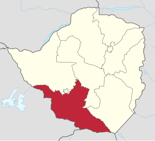
Masvingo, previously named Victoria, is a province in southeastern Zimbabwe. It has a population of 1.638 million as of the 2022 census, ranking fifth out of Zimbabwe's ten provinces. Established by the British South Africa Company, it was one of the five original provinces of Southern Rhodesia. In 1982, two years after Zimbabwean independence, it was renamed Masvingo Province. The province is divided into seven districts, including Masvingo District, which contains the provincial capital Masvingo City.
Matabeleland South is a province in southwestern Zimbabwe. With a population of 683,893 as of the 2012 Zimbabwean census. It is the country's least populated province after Matabeleland North.Matabeleland South and Matabeleland North were established in 1974, when the original Matabeleland Province was bifurcated. The province is divided into six districts. Gwanda is the capital, and Beitbridge is the province's largest town. The name "Matabeleland" is derived from Ndebele, the province's largest ethnic group.

Midlands is a province of Zimbabwe. It has an area of 49,166 square kilometres (18,983 sq mi) and a population of 1,811,905 (2022). It is home to various peoples. Located at a central point in the country, it contains speakers of Shona, Ndebele, Tswana, Sotho and Chewa, as well as of various other languages. Gweru, the third-largest city in Zimbabwe, is the capital of the province.
Buhera South is a constituency represented in the National Assembly of the Parliament of Zimbabwe. Created for the 1985 election, its territory consists of the southern portion of Buhera District, in Manicaland Province in eastern Zimbabwe. Its inaugural member, Kumbirai Kangai of ZANU–PF, held the seat for 23 years until 2008. The current MP since the 2023 election is Ngonidzashe Mudekunye of ZANU–PF.

The Prince Charles Mountains are a major group of mountains in Mac. Robertson Land in Antarctica, including the Athos Range, the Porthos Range, and the Aramis Range. The highest peak is Mount Menzies, with a height of 3,228 m (10,591 ft). Other prominent peaks are Mount Izabelle and Mount Stinear. These mountains, together with other scattered peaks, form an arc about 420 km (260 mi) long, extending from the vicinity of Mount Starlight in the north to Goodspeed Nunataks in the south.
Chivhu, originally known as Enkeldoorn, is a small town in Zimbabwe, with an estimated population of 10,000 in 2007. It is located 146 km (91 mi) south of Harare on the main road south to Masvingo and South Africa.
Rocky Spruit is a village in the province of Mashonaland East, Zimbabwe. It is located on the Mupfure River in the Chiota communal land about 50 kilometres (31 mi) south of Harare.
Eiffel Flats is a village in the province of Mashonaland West, Zimbabwe. It is located about 7 km east of Kadoma.

Binga District is a district of Zimbabwe in southern Africa. It is located in Matabeleland North just south of Kariba Lake, across the lake from Zambia It lies along the southern Zambezi Escarpment.
The Beitbridge Bulawayo Railway (BBR) is a privately owned railway company that provides a rail link in Zimbabwe between Beitbridge at the South African border and Zimbabwe's second city Bulawayo.

Sungkai is a mukim in Batang Padang District, Postcode 35600 Perak, Malaysia. It is accessible via the North–South Expressway's Sungkai Interchange.

Mwenezi, originally known as Nuanetsi, is a small district situated in southern Zimbabwe. It is bisected by the Mwenezi River and the A4 highway, the main thoroughfare that connects the town of Beitbridge, on the border with South Africa, to Masvingo.

Beitbridge is a district in Matabeleland South, Zimbabwe Situated 18 kilometers north of Musina and 548 kilometers north of Johannesburg. Beitbridge district is located in the Lowveld area. The town lies 6 km ESE of the confluence of the Bubye River and the Limpopo on the border with South Africa. It was established in 1929. The town has a population of approximately 43,000 and serves a district of 100,000 people. An estimated 60 percent of Beitbridge's population is female, reflecting extensive male migration to South Africa.
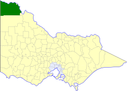
The Shire of Mildura was a local government area located at the northwestern corner of Victoria, Australia, on the Murray River and the South Australian border. The shire covered an area of 10,145 square kilometres (3,917.0 sq mi), and existed from 1890 until 1995. From 1920 onwards, Mildura itself was managed by a separate entity, ultimately known as the City of Mildura.
Masvingo, originally Victoria, encampases metropolitan Masvingo, in Masvingo Province in southern Zimbabwe. The district boasts of the Great Zimbabwe National Monument among its list of tourist attractions. Lake Kyle is also nearby. The people in the district are mostly rural, communal farmers. Mushandike Co-op. is found in the district, in which the villagers use the water from Tokwe River to irrigate their patches of land. Ngomahuru Hospital which is the second largest Psychiatric hospital in the country is also located.
Mudzi District is a district of Mashonaland East Province, Zimbabwe, in southern Africa. It is located in the far eastern part of Zimbabwe. It covers 4,075 square kilometres (1,573 sq mi), all of which is communal land. As of the 2022 census, the district had a population of 158,478, this is up only slightly from the 135,378 of the 2002 census and reflects emigration due to the poverty of the district. It has a single main road, A2, that runs from the town of Mutoko in Mutoko District in the southwest through the district, past the villages of Chifamba, Mudzi, Chingwena, Masarakufa, Nyamuwanga, the town of Kotwa, and the village of Muzezuru to the town of Nyamapanda before entering Mozambique to the northeast.