Meslilloet Mountain

Last updated
Meslilloet Mountain
Meslilloet Mountain.jpg
South aspect
Highest point
Elevation 1,990 m (6,529 ft) [1] [2]
Prominence 685 m (2,247 ft) [1]
Parent peak Pinecone Peak (2,027 m) [2]
Isolation 8.36 km (5.19 mi) [2]
Listing Mountains of British Columbia
Coordinates 49°34′18″N122°49′38″W / 49.57167°N 122.82722°W / 49.57167; -122.82722 [3]
Geography
Canada British Columbia relief location map.jpg
Red triangle with thick white border.svg
Meslilloet Mountain
Location in British Columbia
Canada relief map 2.svg
Red triangle with thick white border.svg
Meslilloet Mountain
Meslilloet Mountain (Canada)
Country Canada
Province British Columbia
District New Westminster Land District
Protected area Pinecone Burke Provincial Park
Parent range Coquitlam Ranges
Coast Mountains
Topo map NTS 92G10 Pitt River

Meslilloet Mountain is a 1,990-metre (6,529-foot) summit located in British Columbia, Canada.

Contents

Description

Meslilloet Mountain is situated 35 km (22 mi) northeast of Vancouver in the Coquitlam Ranges of the Coast Mountains. It is the highest point in the Coquitlam Ranges, [1] and second-highest point in Pinecone Burke Provincial Park. [2] It is set east of the confluence of Meslilloet Creek and Indian River, [4] with precipitation runoff and glacial meltwater from the mountain draining into Meslilloet and Hixon creeks, which are both tributaries of the Indian River. Meslilloet Mountain is more notable for its steep rise above local terrain than for its absolute elevation as topographic relief is significant with the summit rising over 1,100 meters (3,609 ft) above Anne Lake in less than 2 km (1.2 mi). The glacier on Meslilloet Mountain is the closest glacier to Vancouver. [5] The mountain's toponym was officially adopted December 12, 1939, by the Geographical Names Board of Canada. [3]

Climate

Based on the Köppen climate classification, Meslilloet Mountain is located in the marine west coast climate zone of western North America. [6] Most weather fronts originate in the Pacific Ocean, and travel east toward the Coast Mountains where they are forced upward by the range (Orographic lift), causing them to drop their moisture in the form of rain or snowfall. As a result, the Coast Mountains experience high precipitation, especially during the winter months in the form of snowfall. Winter temperatures can drop below −20 °C with wind chill factors below −30 °C. This climate supports a glacier on the peak's north slope. The months July through September offer the most favorable weather for climbing Meslilloet Mountain.

See also

Related Research Articles

<span class="mw-page-title-main">Joffre Peak</span> Mountain in the country of Canada

Joffre Peak is a 2,721-metre (8,927-foot) mountain summit located in the Coast Mountains, in Joffre Lakes Provincial Park, in southwestern British Columbia, Canada. It is the second-highest point of the Joffre Group, which is a subset of the Lillooet Ranges. It is situated 26 km (16 mi) east of Pemberton and 11 km (7 mi) northeast of Lillooet Lake. Joffre is more notable for its steep rise above local terrain than for its absolute elevation as topographic relief is significant with the summit rising 1,500 meters (4,920 ft) above Cayoosh Creek in 4 km (2.5 mi). The nearest higher peak is Mount Matier, 1.6 km (1 mi) to the south. The mountain's climate supports the Matier Glacier on the southwest slope, and the Anniversary Glacier on the southeast slope. Precipitation runoff from the peak drains into Joffre Creek and Cayoosh Creek which are both within the Fraser River watershed.

<span class="mw-page-title-main">Tremor Mountain</span> Mountain in the country of Canada

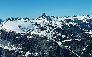
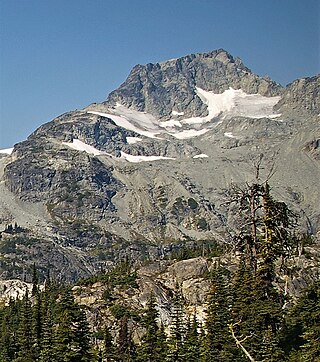
Tremor Mountain is a prominent 2,691-metre (8,829-foot) summit located in the Garibaldi Ranges of the Coast Mountains, in Garibaldi Provincial Park of southwestern British Columbia, Canada. It is the highest point of the Spearhead Range, which is a subset of the Garibaldi Ranges. It is situated 13 km (8 mi) southeast of Whistler, and 8.7 km (5 mi) south of Wedge Mountain, its nearest higher peak. Precipitation runoff from the south side of the peak as well as meltwater from the Platform Glacier drains into Fitzsimmons Creek which is a tributary of the Green River. Meltwater from the Tremor Glacier on the northwestern slope drains to Wedge Creek, and meltwater from the Shudder Glacier on the northeast slope drains into Billygoat Creek, a tributary of the Lillooet River. Tremor Mountain is often climbed as part of the Spearhead Traverse. The first ascent of the mountain was made in 1928 by A.J. Campbell Garibaldi survey party. The mountain's name origin refers to unexplained earth tremors when the first ascent party was on the summit. The mountain's toponym was officially adopted on September 6, 1951, by the Geographical Names Board of Canada.

<span class="mw-page-title-main">Mount Tinniswood</span> Mountain in the country of Canada

Mount Tinniswood is a 2,606-metre (8,550-foot) mountain summit located in British Columbia, Canada.

<span class="mw-page-title-main">Mount Trorey</span> Mountain in the country of Canada

Mount Trorey is a 2,461-metre (8,074-foot) mountain summit located in British Columbia, Canada.

<span class="mw-page-title-main">Mount Farrow</span> Mountain in British Columbia, Canada

Mount Farrow is a mountain summit in British Columbia, Canada.

<span class="mw-page-title-main">Mount Carr</span> Mountain in the country of Canada

Mount Carr is a 2,590-metre (8,497-foot) mountain summit located in British Columbia, Canada.

<span class="mw-page-title-main">Handcar Peak</span> Mountain summit in British Columbia, Canada

Handcar Peak is a 2,338-metre (7,671-foot) mountain summit located in the Railroad Group of the Coast Mountains, in the Pemberton Valley of southwestern British Columbia, Canada. It is situated 38 km (24 mi) northwest of Pemberton and 3 km (2 mi) west of Locomotive Mountain. Precipitation runoff from the peak drains into Sampson Creek and Buck Creek which are both tributaries of the Lillooet River. Handcar Peak is more notable for its steep rise above local terrain than for its absolute elevation as topographic relief is significant with the summit rising over 2,050 meters (6,725 ft) above Lillooet River and Pemberton Valley in approximately 4 km (2.5 mi). The mountain's name was proposed in 1978 by mountaineer Karl Ricker of the Alpine Club of Canada, in association with Railroad Pass, Railroad Creek and other railroad-related names of the immediate vicinity. The toponym was officially adopted January 23, 1979, by the Geographical Names Board of Canada.

<span class="mw-page-title-main">Face Mountain (British Columbia)</span> Mountain summit in British Columbia, Canada

Face Mountain is a 2,485-metre (8,153-foot) mountain summit located in British Columbia, Canada.

<span class="mw-page-title-main">Phalanx Mountain</span> Summit in Garibaldi Provincial Park of British Columbia, Canada

Phalanx Mountain is a 2,441-metre (8,009-foot) summit located in Garibaldi Provincial Park of southwest British Columbia, Canada.

<span class="mw-page-title-main">Isosceles Peak</span> Mountain in the country of Canada

Isosceles Peak is a 2,488-metre (8,163-foot) mountain summit located in British Columbia, Canada.

<span class="mw-page-title-main">Siwhe Mountain</span> Summit located in British Columbia, Canada

Siwhe Mountain is a 2,843-metre (9,327-foot) summit located in British Columbia, Canada.

<span class="mw-page-title-main">Peneplain Peak (British Columbia)</span> Summit in British Columbia, Canada

Peneplain Peak is a 1,707-metre (5,600-foot) summit located in British Columbia, Canada.

<span class="mw-page-title-main">Hour Peak</span> Mountain in the country of Canada

Hour Peak is a 2,329-metre (7,641-foot) mountain summit located in British Columbia, Canada.

<span class="mw-page-title-main">Parapet Peak (Garibaldi Provincial Park)</span> Mountain in the country of Canada

Parapet Peak is a 2,463-metre (8,081-foot) mountain summit located in British Columbia, Canada.

<span class="mw-page-title-main">Gentian Peak</span> Mountain in the country of Canada

Gentian Peak is a 2,197-metre (7,208-foot) summit in British Columbia, Canada.

<span class="mw-page-title-main">Remote Mountain</span>

Remote Mountain is a 3,038-metre (9,967-foot) summit located in British Columbia, Canada.

<span class="mw-page-title-main">Mount Bell (British Columbia)</span>

Mount Bell is a 3,269-metre (10,725-foot) mountain summit in British Columbia, Canada.

<span class="mw-page-title-main">Jubilee Mountain</span>

Jubilee Mountain is a 2,751-metre (9,026-foot) mountain summit in British Columbia, Canada.

<span class="mw-page-title-main">Mount Sir Richard</span>

Mount Sir Richard is a 2,681-metre (8,796-foot) glaciated summit in British Columbia, Canada.

<span class="mw-page-title-main">Shudder Mountain</span>

Shudder Mountain is a 2,671-metre (8,763-foot) summit in British Columbia, Canada.

References

  1. 1 2 3 "Meslilloet Mountain, British Columbia". Peakbagger.com. Retrieved 2023-01-15.
  2. 1 2 3 4 "Meslilloet Mountain, Peakvisor.com" . Retrieved 2023-01-15.
  3. 1 2 "Meslilloet Mountain". Geographical Names Data Base . Natural Resources Canada . Retrieved 2023-01-15.
  4. "Meslilloet Mountain". BC Geographical Names .
  5. Meslillooet Mountain, brmbmaps.com
  6. Peel, M. C.; Finlayson, B. L.; McMahon, T. A. (2007). "Updated world map of the Köppen−Geiger climate classification". Hydrol. Earth Syst. Sci. 11. ISSN   1027-5606.