Related Research Articles

Zimbabwe, officially the Republic of Zimbabwe, is a landlocked country in Southern Africa, between the Zambezi and Limpopo Rivers, bordered by South Africa to the south, Botswana to the southwest, Zambia to the north, and Mozambique to the east. The capital and largest city is Harare, and the second largest is Bulawayo.

The economy of Zimbabwe is a tertiary sector based economy, making up to 56.64% of total GDP as of 2021. Zimbabwe has a $44 billion dollar informal economy in PPP terms which translates to 64.1% of the total economy. Agriculture and mining largely contribute to exports. The economy is set to reach $66 billion by end of 2023, 88% increase in forecast from $35 billion.

The Zimbabwe African National Union – Patriotic Front (ZANU–PF) is a political organisation which has been the ruling party of Zimbabwe since independence in 1980. The party was led for many years under Robert Mugabe, first as prime minister with the Zimbabwe African National Union (ZANU) and then as president from 1987 after the merger with the Zimbabwe African People's Union (ZAPU) and retaining the name ZANU–PF, until 2017, when he was removed as leader.

Matabeleland South is a province in southwestern Zimbabwe. With a population of 683,893 as of the 2012 Zimbabwean census, it is the country's least populous province. After Matabeleland North, it is Zimbabwe's second-least densely populated province. Matabeleland South was established in 1974, when the original Matabeleland Province was divided into two provinces, the other being Matabeleland North. The province is divided into six districts. Gwanda is the capital, and Beitbridge is the province's largest town. The name "Matabeleland" is derived from Ndebele, the province's largest ethnic group.

Midlands is a province of Zimbabwe. It has an area of 49,166 square kilometres (18,983 sq mi) and a population of 1,614,941 (2012). It is home to various peoples. Located at a central point in the country, it contains speakers of Shona, Ndebele, Tswana, Sotho and Chewa, as well as of various other languages. Gweru, the third-largest city in Zimbabwe, is the capital of the province.

The Zimbabwe men's national cricket team, also known as the Chevrons, represents Zimbabwe in men's international cricket and is overseen by Zimbabwe Cricket. Zimbabwe has been a Full Member of the International Cricket Council (ICC) since 1992. As of May, 2023, Zimbabwe was ranked 10th in Tests, 11th in One Day Internationals (ODIs) and 11th in Twenty20 internationals (T20Is) by the ICC.

The United Nations geoscheme is a system which divides 248 countries and territories in the world into six continental regions, 22 geographical subregions, and two intermediary regions. It was devised by the United Nations Statistics Division (UNSD) based on the M49 coding classification. The creators note that "the assignment of countries or areas to specific groupings is for statistical convenience and does not imply any assumption regarding political or other affiliation of countries or territories".
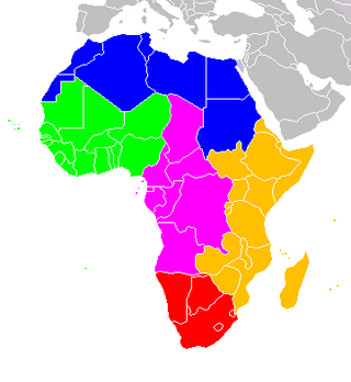
The following is an alphabetical list of subregions in the United Nations geoscheme for Africa, used by the United Nations and maintained by the UNSD department for statistical purposes.
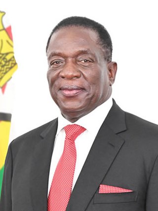
Emmerson Dambudzo Mnangagwa is a Zimbabwean politician who is serving as a President of Zimbabwe since 24 November 2017. A member of ZANU–PF and a longtime ally of former President Robert Mugabe, he held a series of cabinet portfolios and was Mugabe's Vice-President until November 2017, when he was dismissed before coming to power in a coup d'état. He secured his first full term as president in the disputed 2018 general election. Mnangagwa was re-elected in August 2023 general elections with 52.6% of the vote.

Colin de Grandhomme is a Zimbabwean-born former New Zealand international cricketer. He was a member of the New Zealand team that won the 2019–2021 ICC World Test Championship, which was the inaugural tournament.

Bubi is a district in Matabeleland North in Zimbabwe. It is rich in minerals, but lacks infrastructure. Its 2012 census population was 61,883; and had grown to 74,084 by 2022.
Mbire District is a district of the Province Mashonaland Central in Zimbabwe. It is the namesake of the early dinosaur Mbiresaurus, which was discovered in Mbire District.
Murehwa District is a district of the Province Mashonaland East in Zimbabwe.
Seke District is a district of the Province Mashonaland East in Zimbabwe.

Sanyati District is a district of the Province Mashonaland West in Zimbabwe.
Bulilima District is a district of the Province Matabeleland South in Zimbabwe. It was created in 2003 with the break-up of Bulilimamangwe District.

Mangwe District is a district of the Province Matabeleland South in Zimbabwe. It is divided into 17 wards. Some of the wards are Ngwizi, Mphoengs, Sanzukwi, Sangulube, Maninji, Madabe, Mbakwe, Empandeni, Mayobodo, Mambale, Makorokoro, Tshitshi, and Marula. Some villages found in this district are Bulu, Kweneng, Togotsweu. Mangwe used to be a part of bigger district which was known as Bulilimamangwe. Bulilimamangwe was then divided into 3 districts now known as Mangwe, Bulilima and Plumtree.
Matobo, formerly known as Matopos, is a district of the Matabeleland South Province in Zimbabwe.
Umzingwane is a village and seat of the Umzingwane District, in Matabeleland South province, in Zimbabwe.
References
- 1 2 "Zimbabwe: Administrative Division". City Population. Retrieved 30 December 2018.
- ↑ "Census 2012" (PDF). UNSD. UNSD. Retrieved 30 December 2018.
| | This Zimbabwe location article is a stub. You can help Wikipedia by expanding it. |