Milford Haven Waterway

Last updated

Milford Haven Waterway from 1946 Milford Haven harbourmap1946.jpg
Milford Haven Waterway from 1946

Milford Haven Waterway (Welsh: Dyfrffordd Aberdaugleddau) is a natural harbour in Pembrokeshire, Wales. It is a ria or drowned valley which was flooded at the end of the last ice age. [1] [2] The Daugleddau estuary winds west to the sea. As one of the deepest natural harbours in the world, it is a busy shipping channel, trafficked by ferries from Pembroke Dock to Ireland, oil tankers and pleasure craft. Admiral Horatio Nelson, visiting the haven with the Hamiltons, described it as the next best natural harbour to Trincomalee in Ceylon (today's Sri Lanka) and "the finest port in Christendom". [3] Much of the coastline of the Waterway is designated as a Site of Special Scientific Interest, listed as Milford Haven Waterway SSSI.

Contents

History

Early history

From the 790s until the Norman Invasion in 1066, the waterway was used occasionally by Vikings looking for shelter. During one visit in 854, the Viking Chieftain Hubba wintered in the Haven with 23 ships, eventually lending his name to the district of Hubberston. [4] Evidence of metal working in the area was recently excavated, suggesting a level of industrialisation in the period 750–1100. [5]

Milford Haven by Attwood, 1776 Milford Haven Panoramic Attwood.jpg
Milford Haven by Attwood, 1776

A Benedictine priory (Pill Priory) was established at the head of Hubberston Pill in 1170, as a daughter house of St Dogmaels Abbey. Built on virgin land, it stood alongside the priory on Caldey Island as part of the Tironian Order in West Wales, and was dedicated to St Budoc. [6] Founded by Adam de Rupe, it stood until the Dissolution under Henry VIII. [7] In 1171 Henry II designated the area the rendezvous for his Irish expedition. An army of 400 warships, 500 knights and 4,000 men-at-arms gathered in the haven before sailing to Waterford, and on to Dublin, [8] which marked the first time an English king had stood on Irish soil, and the beginning of Henry's invasion of Ireland. St Thomas a Becket chapel was dedicated in 1180, a structure which looked out over the Haven from the north shore of the town. In later years it was used as a beacon for sailors in foul weather, [9] and ultimately as a pig sty, until it was reconsecrated in the 20th century.

St Thomas a Becket Chapel, dedicated 1180 and used as a beacon church Thomas a Beckett Chapel.JPG
St Thomas a Becket Chapel, dedicated 1180 and used as a beacon church

In his play, Cymbeline Act 3, Scene 2 (1611), Shakespeare remarks:

... how far it is to this same blessed Milford: and by the way tell me how Wales was made so happy as to inherit such a haven ... [10]

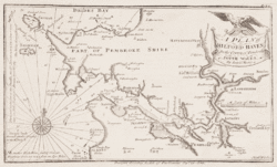
By 1590, two forts had been constructed to defend the entrance to the haven. [11] George Owen of Henllys, in his Description of Penbrokshire, claimed in 1603 that Milford Haven was the most famous port of Christendom. [12] The area however was a source of anxiety for the Tudor monarchy. Its location meant that it is exposed to attacks from Ireland]; a convenient base from which England could be invaded via Wales. [13] In 1405, the French landed in force having left Brest in July with more than twenty-eight hundred knights and men-at-arms led by Jean II de Rieux, the Marshal of France, to support Owain Glyndŵr's rebellion.

In April 1603, Martin Pring used the Haven as his departure point for his exploratory voyage to Virginia. [14] The land comprising the site of Milford, the Manor of Hubberston and Pill, was acquired by the Barlow family following the dissolution of the monasteries in the mid-16th century. It acquired an additional strategic importance in the 17th century as a Royalist military base. Charles I ordered a fort to be built at Pill by Royalist forces and completed in 1643 to prevent Parliamentarian forces from landing at Pembroke Castle and to protect Royalist forces landing from Ireland. On 23 February 1644, a Parliamentarian force led by Rowland Laugharne crossed the Haven and landed at Pill. The fort was gunned from both land and water, and a garrison was placed in Steynton church to prevent a Royalist attack from the garrison at Haverfordwest. The fort was eventually surrendered, and quickly taken, [15] along with St Thomas a Becket chapel. Just five years later in 1649 Milford Haven was again the site of Parliamentarian interest when it was chosen as the disembarkation site for Oliver Cromwell's Invasion of Ireland. Cromwell arrived in the Haven on 4 August, meeting George Monck, [16] before Cromwell and over a hundred crafts left for Dublin on 15 August. [17]

By the late 18th century, the two creeks which would delimit the future town of Milford's boundaries to the east and west, namely Hakin and Castle Pill, were being used as ports for ships to load and unload coal, corn and limestone., [18] A ferry service to Ireland operated from Hakin around the start of the 19th century, although this ceased in the early 19th century. [3] Although surrounding settlements at Steynton, Thornton, Priory, Liddeston and Hubberston/Hakin were established, they were little more than hamlets. The only man-made structures on the future site of Milford were the medieval chapel, and Summer Hill Farm, and its accompanying cottages. [3]

Landscape and history

A plan of Milford Haven from a 1748 survey A plan of Milford Haven in the county of Pembroke south Wales.gif
A plan of Milford Haven from a 1748 survey

Parts of the Haven are within the Pembrokeshire Coast National Park. The northern side is within the Preseli Environmentally Sensitive Area. The area includes: Angle Bay, Carew and Cresswell Rivers, Cosheston Pill, Daugleddau, Gann Estuary, Pembroke River, Pwllcrochan Flats and West Williamston Quarries (Sites of Special Scientific Interest); and the towns of Carew, Haverfordwest, Llangwm, Milford Haven, Neyland and Pembroke, and the Pembroke Dock (Royal Dockyard) Conservation Areas. [1]

The littoral landscape of Milford Haven shows evidence of maritime conquest, settlement, commerce, fishing and defence from the 11th century to the 20th century. Iron Age promontory forts are sited on several of the headlands at the entrance and along the course of the Haven and the Daugleddau. Early medieval, Christian and Viking sites are evidenced by place-names, documentary and epigraphic evidence, such as Early Christian Inscribed Stone monuments. The Norman conquest, achieved by coastally sited castle boroughs, is still obvious at Pembroke, at Haverfordwest, and at Carew. Carew did not develop into a borough, but excavations have shown that a Dark Age stronghold and possible Romano-British site preceded the Norman castle. [1]

Around the start of the 19th century, two new towns were constructed: Milford in 1790 by Sir William Hamilton, and Pembroke Dock in 1802 as the site for a new Royal Naval Dockyard. Both towns have regular planned layouts, both have experienced a history of boom and slump in shipbuilding, fishing and as railheads and ocean terminals. [1] These two towns, which could handle the larger vessels then entering service, concentrated trade that had previously been dispersed at quays, jetties and landing places and small settlements such as Pennar, Lawrenny, Landshipping and Cosheston further up river. [1] These small ports served the coal mines of the Pembrokeshire Coalfield located on both shores of the Daugleddau, and also the large limestone quarries at West Williamston. The Daugleddau ports flourished in the 16th, 17th and 18th centuries, but continued to work through the 19th century by changing to using barges to tranship cargoes down river to bigger vessels at the mid-Haven ports. [1]

In the late 19th century, concerns about the potential threat posed by the French Navy prompted the construction of a number of Palmerston Forts at various strategically important coastal sites, including Milford Haven. Most of the forts are now disused. [1] The late 20th century brought the jetties, oil terminals and shore processing facilities of the oil and power industries. This industry reached its zenith in the 1970s when Middle Eastern supply difficulties forced oil transport to use ocean routes and Very Large Crude Carriers for which the Haven, with its deep waters and westerly position, was particularly suited. [1]

Port

The haven viewed from the town Milford Haven Harbour.jpg
The haven viewed from the town
The harbour viewed from the town Harbour View Milford Haven.JPG
The harbour viewed from the town

Milford Haven is the largest port in Wales, and the third-largest port in the United Kingdom. [19] Shipping operations in Milford Haven are managed by the independent Milford Haven Port Authority as a trust port. The port authority has responsibility for managing Milford Docks, Milford Marina and Pembroke Port and Ferry Terminal. In 2012, it was announced that the Milford waterway was to be declared an Enterprise Zone by the coalition government, due to its importance to the energy sector. [20] [21]

Petrochemical industry

Milford Haven's association with the petro-chemical industry started with the opening of the first oil terminal and oil refinery in 1960; unfortunately this coincided with a serious oil-spill from Esso Portsmouth, the first oil tanker to unload there. Since then, there have been numerous spills of varying magnitude, providing the port authority with a great deal of experience. Uniquely at the time, the harbourmaster instituted the principle of cleaning up first and allocating the blame (and the responsibility of paying for it) later. There are two large oil refineries nearby which represent one fifth of the United Kingdom's oil refining capacity.

In 1978 the tanker Christos Bitas ran aground off the Haven, spilling a portion of its cargo of oil. [22] In 1984, a serious explosion on a tanker being repaired in the Haven resulted in three fatalities. [23] In 1996, it was the location of the Sea Empress oil spill, initially thought to be one of the most devastating oil tanker disasters the UK has ever seen. In the event, recovery has been surprisingly good, perhaps partly because of the very strong tides. The comparable Torrey Canyon spill in 1968, a ship which had been heading to Milford Haven, affected shores further south around southern Cornwall and northern France, was actually far more damaging.

Liquefied natural gas

In light of the dwindling supplies of North Sea gas, Milford Haven has become home to two new LNG terminals which eventually could provide 25% of the UK's gas requirement. Under construction from 2006, South Hook is based on the former Esso refinery facility, while the Dragon LNG terminal is based on a brownfield site of the Gulf oil refinery, now also housing SEMLogistics chemicals. The regasified natural gas is fed through National Grid plc's South Wales Gas Pipeline to the distribution point at Tirley, Gloucestershire. The first vessel, the Q-Flex-class Tembek from Qatar, docked at South Hook on 20 March 2009. The first gas to the Dragon facility was delivered 14 July 2009. [24] [25]

Cruise terminal

The port authority started promoting Pembrokeshire as a cruise destination in 2003 and passenger numbers have steadily increased since then. In July 2008, the first transatlantic liner, the Maasdam arrived in Milford Haven. [26]

Town

The town of Milford Haven was founded as a whaling center in the 18th century, and today the town's port is the fourth largest in the United Kingdom in terms of tonnage [27] and plays an important role in the United Kingdom's energy sector with several oil refineries and one of the biggest LNG terminals in the world. Milford Haven is the second largest settlement in Pembrokeshire, with a population of 13,100; [28] though its community boundaries make it the most populous in the county, with 13,096 people. [29] As a community, Milford Haven takes in the town of Milford Haven itself and the villages of Hakin, Hubberston, Liddeston, Steynton and Thornton.

Power generation

As a first stage of a wave power plant, there will be some testing at West Dale Bay. [30]

Contaminants

Organic and heavy metal chemical pollutants accumulating in variety of species including seaweed mussels, bivalves and worms have been measured in Milford Haven Waterway. [31] This together with information on the sediment concentrations have been assessed in order to aid in the evaluation of the environmental quality of the ria estuary.

Related Research Articles

<span class="mw-page-title-main">Milford Haven</span> Town and community in Wales

Milford Haven is both a town and a community in Pembrokeshire, Wales. It is situated on the north side of the Milford Haven Waterway, an estuary forming a natural harbour that has been used as a port since the Middle Ages.

<span class="mw-page-title-main">Pembroke Dock</span> Human settlement in Wales

Pembroke Dock is a town and a community in Pembrokeshire, South West Wales, 3 miles (4.8 km) northwest of Pembroke on the banks of the River Cleddau. Originally Paterchurch, a small fishing village, Pembroke Dock town expanded rapidly following the construction of the Royal Navy Dockyard in 1814. The Cleddau Bridge links Pembroke Dock with Neyland.

<span class="mw-page-title-main">Preseli Pembrokeshire (UK Parliament constituency)</span> Parliamentary constituency in the United Kingdom, 1997 onwards

Preseli Pembrokeshire is a seat and constituency of the House of Commons of the Parliament of the United Kingdom.

<span class="mw-page-title-main">Milford Haven railway station</span> Railway station in Pembrokeshire, Wales

Milford Haven railway station serves the town of Milford Haven in Pembrokeshire, Wales. Opened on 7 September 1863, it was originally known as Milford, becoming Old Milford by January 1902, and finally being renamed Milford Haven by April 1910. It is the westernmost railway station in Wales, but not in Great Britain as some stations in England and Scotland are further west.

<span class="mw-page-title-main">River Cleddau</span> River in Wales

The River Cleddau consists of the Eastern and Western Cleddau rivers in Pembrokeshire, west Wales. They unite to form the Daugleddau estuary and the important harbour of Milford Haven.

<span class="mw-page-title-main">Steynton</span> Human settlement in Wales

Steynton or Stainton is a parish in the county of Pembrokeshire, Wales, formerly in the hundred of Rhôs and now an area of Milford Haven and in the Community of Tiers Cross. The parish includes the hamlet of Dreenhill, near Haverfordwest. The parish population is about 3,000.

<span class="mw-page-title-main">Pembroke Refinery</span>

The Pembroke Refinery is an oil refinery situated on the Pembrokeshire coast in Wales at Rhoscrowther in the community of Angle. It first came on stream in 1964 and was Regent/Texaco's only British refinery. The refinery occupies a prominent position on the south bank of the Milford Haven Waterway and can be seen for many miles. Around a quarter of the site is within the Pembrokeshire Coast National Park which was created in 1952.

The Esso Refinery at Milford Haven was an oil refinery situated on the Pembrokeshire coast in Wales. Construction started in 1957 and the refinery was opened in 1960 by the Duke of Edinburgh. Construction cost £18 million and the refinery had the initial capacity to process 4.5 million tons of crude oil a year.

<span class="mw-page-title-main">Gulf Refinery, Milford Haven</span>

The Gulf Refinery at Milford Haven was an oil refinery situated on the Pembrokeshire coast in Wales. The refinery, originally owned and operated by Gulf Oil, was opened in August 1968 by Queen Elizabeth II. The plant, constructed at a cost of approximately £35 million, produced a range of petroleum products and occupied an area of 300 acres. It was initially designed to process 60,000 barrels of crude oil per day. The capacity was increased to 119,000 barrels (18,900 m3) a day of oil.

<span class="mw-page-title-main">Hakin</span> Human settlement in Wales

Hakin is a coastal village in Pembrokeshire, Wales. It belongs to the parish of Hubberston in the historical hundred of Roose. It is located directly to the west of the larger town of Milford Haven, and is a district of the community of Milford Haven It had a population of 2,313 inhabitants in 2001.

<span class="mw-page-title-main">Hubberston</span> Human settlement in Wales

Hubberston is a coastal village in Pembrokeshire, Wales. It belongs to the parish of Hubberston in the historical hundred of Roose. It is located directly to the west of the larger town of Milford Haven, and is a district of the community of Milford Haven. It is adjacent to the village of Hakin. It had a population of 2,390 inhabitants in 2001. It is mainly residential in nature.

The town of Milford Haven was founded in 1793 by Sir William Hamilton, who initially invited Quaker whalers from Nantucket to live in his town, and then, in 1797, the Navy Board to create a dockyard for building warships.

<span class="mw-page-title-main">Liddeston</span> Human settlement in Wales

Liddeston is a small coastal village in Pembrokeshire, Wales. It belongs to the Milford North ward of the community of Milford Haven in the historical hundred of Roose. It is located to the north of the town of Milford Haven and the village of Hubberston.

The Sea Empress oil spill occurred at the entrance to the Milford Haven Waterway in Pembrokeshire, Wales on 16 February 1996. The Sea Empress was en route to the Texaco oil refinery near Pembroke when she became grounded on mid-channel rocks at St. Ann's Head. Over the course of a week, she spilt 72,000 tons of crude oil into the sea. The spill occurred within the Pembrokeshire Coast National Park – one of Europe's most important and sensitive wildlife and marine conservation areas. It was Britain's third largest oil spillage and the twelfth largest in the world at the time.

<span class="mw-page-title-main">Hakin Docks railway station</span> Former railway station in Wales

Hakin Dock railway station was a railway station in the town of Milford Haven in Pembrokeshire, Wales. Located within the commercial docks at Hakin, it was constructed to service an anticipated transatlantic trade between Milford Haven and New York City. It was the terminus of the Milford Junction Railway, itself a branch of the South Wales Railway. Opened in 1888, it was short lived and was no longer operating as a station for passengers by the early 20th century.

<span class="mw-page-title-main">Pill Fort</span>

Pill Fort was a sconce fort located on the northern shore of Milford Haven, Pembrokeshire. It was built by Royalist forces in order to prevent Parliamentarian forces landing at Pembroke Castle, and to protect Royalist forces landing from Ireland.

<span class="mw-page-title-main">Pil (placename)</span> Placename element in Brythonic languages

Pîl is a Welsh placename element. The name is defined as the tidal reach of a waterway, suitable as a harbour, and is common along the Bristol Channel and Severn Estuary. The highly localised distribution suggests it may have been part of a common maritime culture on the waterways within the tidal reach of the Severn Sea.

<span class="mw-page-title-main">St David's Church, Hubberston</span> Church in Pembrokeshire, Wales

St David's Church, Hubberston is the parish church of Hubberston, a village on the north bank of the Milford Haven Waterway, in south Pembrokeshire, Wales. The church has 15th century origins, was subsequently renovated and restored, and is a Grade I listed building.

References

  1. 1 2 3 4 5 6 7 8 "Milford Haven Waterway". Countryside Council for Wales. Archived from the original on 5 April 2010. Retrieved 15 January 2010.
  2. "Milford Haven Waterway". Countryside Council for Wales. Archived from the original on 9 June 2011. Retrieved 7 August 2011.
  3. 1 2 3 Wing Commander Ken McKay A Vision of Greatness: The History of Milford 1790–1990, Brace Harvatt Associates, 1989. ISBN   978-0-9515212-0-5
  4. Milford Haven Town Council website History, Chronology of Events Archived 13 March 2012 at the Wayback Machine Retrieved 17 January 2010
  5. Medieval Works Found At LNG Site BBC News Article, 5 April 2005 Retrieved 17 January 2010
  6. A History – The 12th Century: Pill Priory – Tironian House, Retrieved 17 January 2010
  7. A Topographical Dictionary of Wales, Lewis, Samuel (1849) pp. 374–384 Retrieved 17 January 2010
  8. Brennan, Joseph J, A Catechism of the History of Ireland: Ancient, Medieval, and Modern (1878), Kessinger Publishing, 2008. ISBN   1-4367-1986-0
  9. McKay & Springer. Milford Haven Waterway & Town, Tempus Publishing Ltd, 1999. ISBN   978-0-7524-1589-5
  10. BBC: Milford Haven Slideshow Tour Retrieved 19 January 2010
  11. Genealogy World – FORT HUBBERSTONE Mason, Graham, Retrieved 20 May 2011
  12. Owen, George. The Description of Pembrokeshire, Gomer Press, 1994. ISBN   978-1-85902-120-0
  13. Jones, J Gwynfor. Wales & The Tudor State, Cardiff University of Wales Press, 1989. ISBN   0-7083-1039-7
  14. Hoyt, Epaphras Antiquarian Researches: Comprising A History Of The Indian Wars In The Country Bordering The Connecticut River, Kessinger Publishing, 2007. ISBN   0-548-25343-9
  15. "1643–4: Civil War in Pembrokeshire". Retrieved 18 January 2010
  16. 4 August 1649 "Timeline: British Civil wars" Retrieved 19 January 2010
  17. "A Short History of Ireland: 'The righteous judgement of God': Cromwell". BBC. Retrieved 19 January 2010
  18. George, Barbara J; Pembrokeshire Sea Trading Before 1900 Archived 15 December 2010 at the Wayback Machine Field Studies Journal, pp. 5–6; Retrieved 19 January 2010
  19. "Sandy Haven to Milford Haven coastal walk". Walk through time. BBC. Retrieved 15 January 2009.
  20. 'Energy industry zones for Snowdonia and Haven Waterway BBC News Article: 17 May 2012
  21. 'AM praises 'huge benefits' enterprise zone will bring Milford Mercury Article: 26 May 2012
  22. Jones, Tim (17 October 1978). "Gales forecast as salvage team battles against time to save stricken tanker". The Times. No. 60434. London. col D, p. 1.
  23. British Tanker's Blasts Kill Three Sarasota Herald Tribune, 16.06.84
  24. "First liquid gas delivery in port". BBC Wales. 20 March 2009. Retrieved 20 March 2009.
  25. "Fast facts". Archived from the original on 25 June 2014. Retrieved 13 June 2014.
  26. "Ship cruises in for record visit". BBC News. 24 July 2008. Retrieved 15 January 2009.
  27. One Wales: Connecting the Nation – The Wales Transport Strategy Welsh Assembly Government, April 2008, page 29 Retrieved 17 January 2010
  28. KS01 Usual Resident Population: Census 2001 'Key Statistics for Urban Areas', Office For National Statistics D8271.xls (PDF) line 2540 Archived 20 August 2011 at the Wayback Machine Retrieved 17 January 2010
  29. Settlement Populations, Pembrokeshire County Council 2001 Census Retrieved 17 January 2010
  30. "Wave power plan for Welsh coast". BBC News. 15 December 2005. Retrieved 15 January 2009.
  31. Langston, W. J.; O’Hara, S.; Pope, N. D.; Davey, M.; Shortridge, E.; Imamura, M.; Harino, H.; Kim, A.; Vane, C. H. (2011). "Bioaccumulation surveillance in Milford Haven Waterway" (PDF). Environmental Monitoring and Assessment. 184 (1): 289–311. doi:10.1007/s10661-011-1968-z. ISSN   0167-6369. PMID   21432028. S2CID   19881327.

Further reading

51°42′00″N5°06′47″W / 51.7°N 5.113°W / 51.7; -5.113