Physical
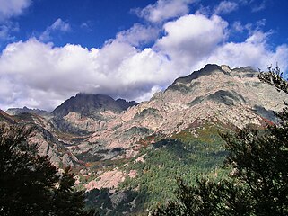
Monte d'Oro has prominence of 962 metres (3,156 ft) and elevation of 2,389 metres (7,838 ft). It is isolated by 8.64 kilometres (5.37 mi) from A Maniccia-Crêt Sud, a sub-peak of the 2,496 metres (8,189 ft) A Maniccia. The conical mountain rises about 1,000 metres (3,300 ft) over the Col de Vizzavona road pass. From its peak, the view extends far over Corsica, blocked only by distant mountains such as Monte Rotondo to the north and Monte Renoso to the south.
The hike to the peak from the Col de Vazzavona is fairly challenging, including long and steep routes with an exposed ridge traverse, a hanging scree field and a climb through exposed ledges and chimneys. The weather can also be treacherous, with strong winds, heavy clouds and storms.

Bocognano is a commune located in the department of Corse-du-Sud, on the island of Corsica, France. The village, situated at the south-western side of the climb to the Col de Vizzavona, belongs to the micro of Celavo which is historically the capital.

Monte San Petrone is a mountain in the department of Haute-Corse on the island of Corsica, France. It is the highest mountain in the Monte San Petrone massif, the southernmost of the schist massifs of the northeast of the island.

Punta Artica or Monte Artica is a mountain in the department of Haute-Corse on the island of Corsica, France. It is in the Monte Rotondo massif.

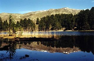
Monte Rotondo is a mountain in the department of Haute-Corse on the island of Corsica, France. At 2,622 metres (8,602 ft) it is the second highest in Corsica, after Monte Cinto. It is the highest point in the Monte Rotondo massif. The view from the summit is spectacular.

Monte Astu or Monte Asto is a mountain in the department of Haute-Corse on the island of Corsica, France.

The Capu Biancu is a mountain in the department of Haute-Corse on the island of Corsica, France.

The Monte Cinto massif is one of the main massifs in the island of Corsica, France, taking its name from the highest mountain in Corsica, Monte Cinto. It is the northernmost and highest of the four massifs that form the spine of the island. The massif is mostly in the Haute-Corse department, but the southwest of the massif is in the Corse-du-Sud department.
Monte Stello is a mountain in the department of Haute-Corse on the island of Corsica, France. It is the second highest point in the Monte Stello massif, which forms the backbone of Cap Corse.

Cima di e Follicie is a mountain in the department of Haute-Corse on the island of Corsica, France. It is in the Monte Stello massif on Cap Corse.
The Monte Rotondo massif is a chain of mountains in the south of the island of Corsica, France. It takes its name from Monte Rotondo, the highest peak.
The Guagno is a river in the north of the department of Corse-du-Sud, Corsica, France. It is a tributary of the river Liamone.

The Col de Santo Stefano Corsican: Bocca di San Stefanu) is a mountain pass in the Haute-Corse department of Corsica, France. It is one of the main passes in Corsica, running between the massifs of Monte Stello to the north and Monte Astu to the south. It provides a route from the Saint-Florent region to the northwest and Biguglia in the eastern coastal plain.
The Col de Teghime is a mountain pass in the Haute-Corse department of Corsica, France. The pass is in the south of the Monte Stello massif and is one of the main passes in the island.

Monte Renoso is a mountain in the departments of Haute-Corse and Corse-du-Sud on the island of Corsica, France. It is the highest peak in the Monte Renoso massif.

The Col de Prato is a mountain pass in the Haute-Corse department of Corsica, France.

The Col de Sainte-Marie or Col de Pietralba is a mountain pass in the Haute-Corse department of Corsica, France. It is between the Monte Astu massif to the east and the Monte Cinto massif to the west. It leads from the Ostriconi valley to the northwest to the Tartagine valley, which leads to the east coast.

Capo al Berdato is a mountain in the department of Haute-Corse on the island of Corsica, France. It is in the Monte Cinto massif.

Punta Minuta is a 2,556 metres (8,386 ft) mountain in the department of Haute-Corse on the island of Corsica, France. It is in the Monte Cinto massif.

Monte Padro is a 2,389 metres (7,838 ft) mountain in the department of Haute-Corse on the island of Corsica, France. It is in the Monte Cinto massif.
This page is based on this
Wikipedia article Text is available under the
CC BY-SA 4.0 license; additional terms may apply.
Images, videos and audio are available under their respective licenses.