
Brunswick is a town in Rensselaer County, New York, United States. The municipality was originally settled in the early 18th century. During its history, it had been part of Albany County, Rensselaerswyck, and Troy, before its incorporation in 1807. It is bordered on the west by the city of Troy; on the north by Schaghticoke and Pittstown; on the east by Grafton; and on the south by Poestenkill and North Greenbush. The population was 11,941 at the 2010 census. The source of the town's name is not certain, though some claim it comes from the source of its first inhabitants from the province of Brunswick-Lüneburg in Germany.
Edmundston is a city in Madawaska County, New Brunswick, Canada.
Charlotte County is the southwest-most county of New Brunswick, Canada.

Northumberland County is located in northeastern New Brunswick, Canada.

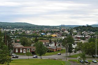
St. Stephen is a Canadian town in Charlotte County, New Brunswick, situated on the east bank of the St. Croix River around the intersection of New Brunswick Route 170 and the southern terminus of New Brunswick Route 3. The St. Croix River marks a section of the Canada–United States border, forming a natural border between Calais, Maine and St. Stephen. U.S. Route 1 parallels the St. Croix river for a few miles, and is accessed from St. Stephen by three cross-border bridges.
Route 3 is 92 kilometres long and goes from Route 170 in St. Stephen to Route 2 at Longs Creek, near Fredericton.

Hampton is a town in Kings County, New Brunswick, Canada.
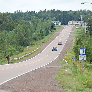
Route 115 is a highway in New Brunswick, Canada; running from a junction with Route 134 in the Lewisville neighbourhood of Moncton to Route 134 in Saint-François-de-Kent (near Bouctouche, a distance of 44 kilometres.
Berry Mills is a small, unincorporated community north-west of Moncton, New Brunswick. It is located around the main Canadian National Railway line, which was formerly the Intercolonial Railway of Canada line. Major Intersections include New Brunswick Route 128 and New Brunswick Route 2 as well as Homestead Road and New Brunswick Route 128. Berry Mills also includes the mostly forest area of Lutesville, New Brunswick.
Ford's Mills is a settlement in Weldford Parish, New Brunswick at the intersection of Route 470 and Route 510 on the Richibucto River.
Route 128 is a provincial highway in the Canadian province of New Brunswick. The highway starts in Lutes Mountain as Homestead Road at Route 126. The road travels in a horseshoe pattern through two small communities before ending in the city of Moncton at an interchange with Route 15. In the community of Berry Mills, New Brunswick, the road is called Berry Mills Road and in Moncton, Route 128 is also designated Killam Drive.
Route 465 is an 25-kilometre (16 mi) long north-east secondary highway in the northwest portion of New Brunswick, Canada.
Route 470 is an 18-kilometre (11 mi) long west–east secondary highway in the northwest portion of New Brunswick, Canada.
Route 745 is a 23-kilometre (14 mi) long mostly north–south secondary highway in the southwestern portion of New Brunswick, Canada. Most of the route is in Charlotte County.
Route 750 is a 19-kilometre (12 mi) long mostly north–south secondary highway in the southwestern portion of New Brunswick, Canada. Most of the route is in Charlotte County.

Waterford is a civil parish in Kings County, New Brunswick, Canada.

Saint Stephen is a civil parish in Charlotte County, New Brunswick, Canada, located in the southwestern corner of the province. It comprises one town, two local service districts (LSDs), and part of a third LSD, all of which are members of the Southwest New Brunswick Service Commission (SNBSC).

Saint James is a civil parish in Charlotte County, New Brunswick, Canada, located north of St. Stephen. It comprises one local service district (LSD) and part of a second, both of which are members of the Southwest New Brunswick Service Commission (SNBSC).

Saint David is a civil parish in Charlotte County, New Brunswick, Canada, located northeast of St. Stephen and northwest of Saint Andrews. It comprises a single local service district (LSD), which is a member of the Southwest New Brunswick Service Commission (SNBSC).
Musquash is a Canadian rural community in Saint John County, New Brunswick. It is located 5 km (3.1 mi) west southwest of the community of Prince of Wales in Musquash Parish.
