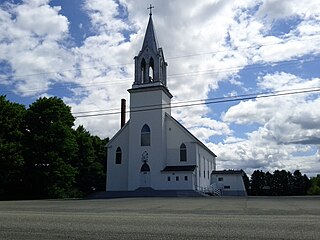
Saint James St. James | |
---|---|
Country | Canada |
Province | New Brunswick |
County | Charlotte County |
Erected | 1823 |
Area | |
• Land | 552.90 km2 (213.48 sq mi) |
Population (2021) [1] | |
• Total | 1,024 |
• Density | 1.9/km2 (5/sq mi) |
• Change 2016-2021 | 13.7% |
• Dwellings | 499 |
Time zone | UTC-4 (AST) |
• Summer (DST) | UTC-3 (ADT) |
Saint James is a geographic parish in Charlotte County, New Brunswick, Canada, [4] located north of St. Stephen.
For governance purposes, Little Ridge and areas to the south are part of the town of the Municipal District of St. Stephen, [5] while the rest of the parish is part of the Southwest rural district, [6] both of which are members of the Southwest New Brunswick Service Commission. [7]
Prior to the 2023 governance reform, it comprised one local service district (LSD) and part of a second, both of which were members of the Southwest New Brunswick Service Commission (SNBSC). [8]
The Census subdivision of the same name shares the parish's borders. [1]
Historian William Francis Ganong believed the name suggested by other Saint names in the area. [9]
Five of the original six mainland parishes of Charlotte County used names of major saints recognised by the Church of England: Andrew (Scotland), David (Wales), George (England), Patrick (Ireland), and Stephen, and Saint James was the first new mainland parish to be erected in the county.
Saint James was erected in 1823 from Saint Stephen Parish and unassigned lands to the north of Saint Stephen and Saint David Parish; [10] the northern line of Saint Stephen had run above Gleason Point, Oak Hill, and DeWolfe.
Saint James Parish is bounded: [2] [11] [12]
Both LSDs assessed for only the basic LSD services of fire protection, police services, land use planning, emergency measures, and dog control. [13]
The local service district of the parish of Saint James originally comprised the entire parish.
The LSD was established in 1969 to assess for community services, [14] in this case to provide ambulance service after local funeral homes ceased doing so. [15] Fire protection was added in 1970. [16]
The taxing authority was 520.00 Saint James. [13]
Western Charlotte comprised an area along the St. Croix River, running east from the mouth of Canoose Stream, then south along Green Brown Brook until it strikes the rear line of grants along the eastern side of the Basswood Ridge Road until it crosses Robinson Cross Road, southwesterly until it strikes the rear line of grants along Route 740, then southerly to the parish line, following the parish line to the western line of grants along Route 740, then running southerly along grant lines to St. Stephen, westerly along the St. Stephen limits to the western end of the town, then northwesterly along the rear line of grants west of Barter Settlement Road before turning southwesterly to strike the Mohannes Stream about midway between the two crossings of the Burnt Hill Road, upstream to about midway between the Chandler Road and the parish line, turning southwesterly to the rear line of grants along Route 725, then northwesterly to the parish line and southwest to the St. Croix. [17]
The LSD was established in 1988 to add first aid and ambulance services. [18]
The taxing authority was 528.00 Western Charlotte. [13]
Communities at least partly within the parish. [11] [12] [19]
Bodies of water [lower-alpha 1] at least partly within the parish. [11] [12] [19]
Islands at least partly within the parish. [11] [12] [19]
Parks, historic sites, and other noteworthy places at least partly within the parish. [11] [12] [19] [20]
2021 | 2016 | 2011 | |
---|---|---|---|
Population | 1,024 (-13.7% from 2016) | 1,186 (-4.4% from 2011) | 1,241 (-8.1% from 2006) |
Land area | 552.90 km2 (213.48 sq mi) | 556.62 km2 (214.91 sq mi) | 556.00 km2 (214.67 sq mi) |
Population density | 1.9/km2 (4.9/sq mi) | 2.1/km2 (5.4/sq mi) | 2.2/km2 (5.7/sq mi) |
Median age | 52 (M: 52, F: 53.2) | 47.7 (M: 47.8, F: 47.5) | 44.5 (M: 42.2, F: 46.5) |
Private dwellings | 450 (total) | 570 (total) | 590 (total) |
Median household income | $45,184 | $51,753 |
|
|
| |||||||||||||||||||||||||||
[27] [28] |
Canada Census Mother Tongue - Saint James Parish, New Brunswick [27] | ||||||||||||||||||
---|---|---|---|---|---|---|---|---|---|---|---|---|---|---|---|---|---|---|
Census | Total | French | English | French & English | Other | |||||||||||||
Year | Responses | Count | Trend | Pop % | Count | Trend | Pop % | Count | Trend | Pop % | Count | Trend | Pop % | |||||
2011 | 1,235 | 1,200 | 9.4% | 97.17% | 25 | 40.0% | 2.02% | 0 | 0.0% | 0.00% | 10 | n/a% | 0.81% | |||||
2006 | 1,340 | 1,325 | 4.0% | 98.88% | 15 | 0.0% | 1.12% | 0 | 0.0% | 0.00% | 0 | 0.0% | 0.00% | |||||
2001 | 1,395 | 1,380 | 0.0% | 98.92% | 15 | 33.3% | 1.08% | 0 | 0.0% | 0.00% | 0 | 0.0% | 0.00% | |||||
1996 | 1,390 | 1,380 | n/a | 99.28% | 10 | n/a | 0.72% | 0 | n/a | 0.00% | 0 | n/a | 0.00% |
Highways and numbered routes that run through the parish, including external routes that start or finish at the parish limits: [29]
Wicklow is a geographic parish in Carleton County, New Brunswick, Canada, forming the northwestern corner of Carleton County.
Dalhousie is a geographic parish in Restigouche County, New Brunswick, Canada.
Bathurst is a geographic parish in Gloucester County, New Brunswick, Canada.
New Bandon is a geographic parish in Gloucester County, New Brunswick, Canada.
Paquetville is a geographic parish in Gloucester County, New Brunswick, Canada.
Allardville is a geographic parish in Gloucester County, New Brunswick, Canada,
Saint-Joseph is a geographic parish in Madawaska County, New Brunswick, Canada.
Notre-Dame-de-Lourdes is a geographic parish in Madawaska County, New Brunswick, Canada.
Saint-Léonard is a geographic parish in Madawaska County, New Brunswick, Canada.
Harcourt is a geographic parish in Kent County, New Brunswick, Canada.
McAdam is a geographic parish in York County, New Brunswick, Canada.
Stanley is a geographic parish in York County, New Brunswick, Canada.
Hampton is a geographic parish in Kings County, New Brunswick, Canada.
Pennfield is a geographic parish in Charlotte County, New Brunswick, Canada, located west of Saint John located east of St. George and west of Saint John.
Saint George is a geographic parish in Charlotte County, New Brunswick, Canada, located between St. Stephen and Saint John.
Dumbarton is a geographic parish in Charlotte County, New Brunswick, Canada, located inland north of St. George and south of Harvey.
Saint Patrick is a geographic parish in Charlotte County, New Brunswick, Canada, located west of St. George and Saint Andrews.
Saint Croix is a geographic parish in Charlotte County, New Brunswick, Canada, straddling Route 1 to the north of the original town of Saint Andrews.
Saint Stephen is a geographic parish in Charlotte County, New Brunswick, Canada, located in the southwestern corner of the province.
Saint David is a geographic parish in Charlotte County, New Brunswick, Canada, located northeast of St. Stephen and northwest of Saint Andrews.