Dumbarton Parish, New Brunswick

Last updated

Dumbarton
Charlotte County NB - Dumbarton Parish.png
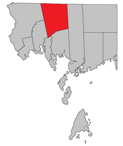
Location within Charlotte County.
Country Flag of Canada (Pantone).svg  Canada
Province Flag of New Brunswick.svg  New Brunswick
County Charlotte County
Erected1856
Area
[1]
  Land373.20 km2 (144.09 sq mi)
Population
 (2021) [1]
  Total346
  Density0.9/km2 (2/sq mi)
  Change 2016-2021
Increase2.svg 3.3%
  Dwellings
182
Time zone UTC-4 (AST)
  Summer (DST) UTC-3 (ADT)

Dumbarton is a geographic parish in Charlotte County, New Brunswick, Canada, [4] located inland north of St. George and south of Harvey.

Contents

For governance purposes, the entire parish is part of the Southwest rural district, [5] which is a member of the Southwest New Brunswick Service Commission. [6]

Prior to the 2023 governance reform, it comprised a single local service district (LSD), which was a member of the Southwest New Brunswick Service Commission (SNBSC). [7]

The Census subdivision of the same name shares the parish's boundaries. [1]

Origin of name

The parish may have been named for the town of Dumbarton, Scotland, [8] although William Francis Ganong considered this uncertain.

History

Dumbarton was erected from northern Saint Patrick Parish in 1856. [9]

It included a small triangle of Saint Croix Parish southwest of the junction of Wilson Road and Route 127 until 1958. [10]

Boundaries

Dumbarton Parish is bounded: [2] [11] [12]

Local service district

The local service district of the parish of Dumbarton comprised the entire parish. [13]

The LSD was established in 1969 to assess for community services, [14] in this case to provide ambulance service after local funeral homes ceased doing so. [15] Fire protection was added in 1970. [16]

In 2021, the LSD assessed for only the basic LSD services of fire protection, police services, land use planning, emergency measures, and dog control. [17] The taxing authority is 510.00 Dumbarton.

Communities

Communities at least partly within the parish. [11] [12] [18]

Bodies of water

Bodies of water [lower-alpha 1] at least partly within the parish. [11] [12] [18]

Islands

Parks, historic sites, and other noteworthy places at least partly within the parish. [11] [12] [18]

Demographics

Population

Canada census – Dumbarton community profile
2021 2016 2011
Population346 (+3.3% from 2016)335 (-9.0% from 2011)368 (+3.4% from 2006)
Land area373.20 km2 (144.09 sq mi)374.43 km2 (144.57 sq mi)375.08 km2 (144.82 sq mi)
Population density0.9/km2 (2.3/sq mi)0.9/km2 (2.3/sq mi)1.0/km2 (2.6/sq mi)
Median age50.4 (M: 50.0, F: 52.0)51.3 (M: 49.0, F: 52.1)48.4 (M: 47.8, F: 48.6)
Private dwellings182 (total)  158 (occupied)195 (total) 204 (total) 
Median household income$60,800$46,784$.N/A
Notes: 2011 income data for this area has been suppressed for data quality or confidentiality reasons.
References: 2021 [19] 2016 [20] 2011 [21] earlier [22] [23]
Historical Census Data - Dumbarton Parish, New Brunswick
YearPop.±%
1991 426    
1996 447+4.9%
YearPop.±%
2001 430−3.8%
2006 356−17.2%
YearPop.±%
2011 368+3.4%
2016 335−9.0%
[24] [25]

Language

Canada Census Mother Tongue - Dumbarton Parish, New Brunswick [24]
CensusTotal
English
French
English & French
Other
YearResponsesCountTrendPop %CountTrendPop %CountTrendPop %CountTrendPop %
2011
375
360Increase2.svg 4.2%96.00%15Increase2.svg n/a%4.00%0Steady2.svg 0.0%0.00%0Decrease2.svg 100.0%0.00%
2006
355
345Decrease2.svg 19.8%97.18%0Steady2.svg 0.0%0.00%0Steady2.svg 0.0%0.00%10Increase2.svg n/a%2.82%
2001
430
430Decrease2.svg 3.4%100.00%0Steady2.svg 0.0%0.00%0Steady2.svg 0.0%0.00%0Steady2.svg 0.0%0.00%
1996
445
445n/a100.00%0n/a0.00%0n/a0.00%0n/a0.00%

Access Routes

Highways and numbered routes that run through the parish, including external routes that start or finish at the parish limits: [26]

See also

Notes

  1. Not including brooks, ponds or coves.

Related Research Articles

<span class="mw-page-title-main">Kingsclear Parish, New Brunswick</span> Parish in New Brunswick, Canada

Kingsclear is a geographic parish in York County, New Brunswick, Canada.

<span class="mw-page-title-main">Dundas Parish, New Brunswick</span> Parish in Canada

Dundas is a geographic parish in Kent County, New Brunswick, Canada.

<span class="mw-page-title-main">Inkerman Parish, New Brunswick</span> Parish in New Brunswick, Canada

Inkerman is a geographic parish in Gloucester County, New Brunswick, Canada.

<span class="mw-page-title-main">New Bandon Parish, New Brunswick</span> Parish in New Brunswick, Canada

New Bandon is a geographic parish in Gloucester County, New Brunswick, Canada.

<span class="mw-page-title-main">Paquetville Parish, New Brunswick</span> Parish in New Brunswick, Canada

Paquetville is a geographic parish in Gloucester County, New Brunswick, Canada.

<span class="mw-page-title-main">Allardville Parish, New Brunswick</span> Parish in New Brunswick, Canada

Allardville is a geographic parish in Gloucester County, New Brunswick, Canada,

<span class="mw-page-title-main">Rivière-Verte Parish, New Brunswick</span> Parish in New Brunswick, Canada

Rivière-Verte is a geographic parish in Madawaska County, New Brunswick, Canada.

<span class="mw-page-title-main">Saint-Léonard Parish, New Brunswick</span> Parish in New Brunswick, Canada

Saint-Léonard is a geographic parish in Madawaska County, New Brunswick, Canada.

<span class="mw-page-title-main">McAdam Parish, New Brunswick</span> Parish in New Brunswick, Canada

McAdam is a geographic parish in York County, New Brunswick, Canada.

<span class="mw-page-title-main">Prince William Parish, New Brunswick</span> Parish in New Brunswick, Canada

Prince William is a geographic parish in York County, New Brunswick, Canada.

<span class="mw-page-title-main">Saint Marys Parish, New Brunswick</span> Parish in New Brunswick, Canada

Saint Marys is a geographic parish in York County, New Brunswick, Canada.

<span class="mw-page-title-main">Stanley Parish, New Brunswick</span> Parish in New Brunswick, Canada

Stanley is a geographic parish in York County, New Brunswick, Canada.

<span class="mw-page-title-main">Hampton Parish, New Brunswick</span> Parish in New Brunswick, Canada

Hampton is a geographic parish in Kings County, New Brunswick, Canada.

<span class="mw-page-title-main">Pennfield Parish, New Brunswick</span> Parish in Canada

Pennfield is a geographic parish in Charlotte County, New Brunswick, Canada, located west of Saint John located east of St. George and west of Saint John.

<span class="mw-page-title-main">Saint George Parish, New Brunswick</span> Parish in Canada

Saint George is a geographic parish in Charlotte County, New Brunswick, Canada, located between St. Stephen and Saint John.

<span class="mw-page-title-main">Saint Patrick Parish, New Brunswick</span> Parish in Canada

Saint Patrick is a geographic parish in Charlotte County, New Brunswick, Canada, located west of St. George and Saint Andrews.

<span class="mw-page-title-main">Saint Croix Parish, New Brunswick</span> Parish in Canada

Saint Croix is a geographic parish in Charlotte County, New Brunswick, Canada, straddling Route 1 to the north of the original town of Saint Andrews.

<span class="mw-page-title-main">Saint Stephen Parish, New Brunswick</span> Parish in Canada

Saint Stephen is a geographic parish in Charlotte County, New Brunswick, Canada, located in the southwestern corner of the province.

<span class="mw-page-title-main">Saint James Parish, New Brunswick</span> Parish in Canada

Saint James is a geographic parish in Charlotte County, New Brunswick, Canada, located north of St. Stephen.

<span class="mw-page-title-main">Saint David Parish, New Brunswick</span> Parish in Canada

Saint David is a geographic parish in Charlotte County, New Brunswick, Canada, located northeast of St. Stephen and northwest of Saint Andrews.

References

  1. 1 2 3 "Census Profile". Statistics Canada. 26 October 2022. Retrieved 29 October 2022.
  2. 1 2 "Chapter T-3 Territorial Division Act". Government of New Brunswick. Retrieved 5 June 2023.
  3. "Chapter I-13 Interpretation Act". Government of New Brunswick. Retrieved 5 June 2023.
  4. The Territorial Division Act [2] divides the province into 152 parishes, the cities of Saint John and Fredericton, and one town of Grand Falls. The Interpretation Act [3] clarifies that parishes include any local government within their borders.
  5. "Southwest Regional Service Commission: RD 10". Government of New Brunswick. Retrieved 5 June 2023.
  6. "Regions Regulation – Regional Service Delivery Act". Government of New Brunswick. 21 July 2022. Retrieved 5 June 2023.
  7. "Communities in each of the 12 Regional Service Commissions (RSC) / Les communautés dans chacune des 12 Commissions de services régionaux (CSR)" (PDF), Government of New Brunswick, July 2017, retrieved 1 February 2021
  8. Ganong, William F. (1896). A Monograph of the Place-Nomenclature of the Province of New Brunswick. Royal Society of Canada. p. 231. Retrieved 17 March 2021.
  9. "19 Vic. c. 25 An Act to erect the upper part of the Parish of Saint Patrick, in the County of Charlotte, into a separate Town or Parish.". Acts of the General Assembly of Her Majesty's Province of New Brunswick, Passed in the Months of March, April, and May 1856. Fredericton: Government of New Brunswick. 1856. pp. 42–43. Retrieved 27 March 2021.
  10. "7 Elizabeth II, 1958, c. 56 An Act to Amend the Territorial Division Act". Acts of the Legislature of New Brunswick Passed During the Session of 1958. Fredericton: Government of New Brunswick. 1958. pp. 117–119.
  11. 1 2 3 4 "No. 145". Provincial Archives of New Brunswick. Department of Natural Resources and Energy Development. Retrieved 3 July 2021. Remainder of parish on maps 146, 153, 154, and 161 at same site.
  12. 1 2 3 4 "440" (PDF). Transportation and Infrastructure. Government of New Brunswick. Retrieved 3 July 2021. Remainder of parish on mapbooks 441, 455, 456, 468, 469, and 479 at same site.
  13. "New Brunswick Regulation 84-168 under the Municipalities Act (O.C. 84-582)". Government of New Brunswick. Retrieved 6 February 2021.
  14. "Regulation 69–17 under the Municipalities Act (O. C. 69–161)". The Royal Gazette. 127. Fredericton: 149. 12 March 1969.
  15. "St. Stephen – Milltown Ambulance Brigade". The New Brunswick Municipal Monthly. 25 (3). Fredericton, NB: Department of Municipal Affairs: 5. March 1969.
  16. "Regulation 70–63 under the Municipalities Act (O. C. 70–385)". The Royal Gazette. 128. Fredericton: 343–344. 17 June 1970.
  17. "2020 Local Government Statistics for New Brunswick" (PDF). Department of Environment and Local Government. p. 55. Retrieved 6 February 2021.
  18. 1 2 3 "Search the Canadian Geographical Names Database (CGNDB)". Government of Canada. Retrieved 4 July 2021.
  19. "2021 Community Profiles". 2021 Canadian Census . Statistics Canada. 4 February 2022. Retrieved 19 October 2023.
  20. "2016 Community Profiles". 2016 Canadian Census . Statistics Canada. 12 August 2021. Retrieved 8 September 2019.
  21. "2011 Community Profiles". 2011 Canadian Census . Statistics Canada. 21 March 2019. Retrieved 15 March 2014.
  22. "2006 Community Profiles". 2006 Canadian Census . Statistics Canada. 20 August 2019.
  23. "2001 Community Profiles". 2001 Canadian Census . Statistics Canada. 18 July 2021.
  24. 1 2 Statistics Canada: 1996, 2001, 2006, 2011 census
  25. "Census Profile, 2016 Census Dumbarton, Parish [Census subdivision], New Brunswick". Statistics Canada. Retrieved 8 September 2019.
  26. Atlantic Canada Back Road Atlas ISBN   978-1-55368-618-7 Pages 4, 12


45°23′42″N67°04′26″W / 45.394954°N 67.073765°W / 45.394954; -67.073765 (Dumbarton Parish, New Brunswick)