Saint Croix Parish, New Brunswick

Last updated

Saint Croix
St. Croix
Charlotte County NB - Saint Croix Parish.png
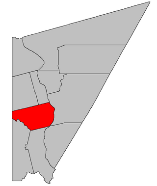
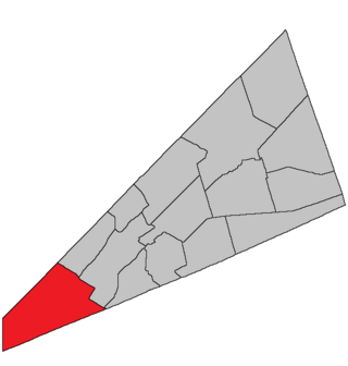
Location within Charlotte County.
Country Flag of Canada (Pantone).svg  Canada
Province Flag of New Brunswick.svg  New Brunswick
County Charlotte County
Erected1874
Named for St. Croix River
Area
[1]
  Land78.60 km2 (30.35 sq mi)
Population
 (2021) [1]
  Total648
  Density8.2/km2 (21/sq mi)
  Change 2016-2021
Decrease2.svg 1.4%
  Dwellings
346
Time zone UTC-4 (AST)
  Summer (DST) UTC-3 (ADT)
Highways Route 1 / Route 127 / Route 170 / Route 760 [2]

Saint Croix is a geographic parish in Charlotte County, New Brunswick, Canada, [5] straddling Route 1 to the north of the original town of Saint Andrews.

Contents

For governance purposes, all of the parish south of Route 1 is part of the post-reform town of Saint Andrews, [6] the Board Road area is part of the town of the Municipal District of St. Stephen, [6] and the remainder north of Route 1 is part of the Southwest rural district, [7] all of which are members of the Southwest New Brunswick Service Commission. [8]

Prior to the 2023 governance reform, it comprised two local service districts, [9] both of which were members of the Southwest New Brunswick Service Commission (SNBSC). [10]

The Census subdivision of the same name includes the entire parish, while the former LSD of Bayside is used as a Designated place. [1]

Origin of name

The parish's name comes from the St. Croix River, [11] which forms part of its western border.

History

Saint Croix was erected in 1874 from the northern part of Saint Andrews Parish, [12] including parts of Saint Andrews, Saint David, and Saint Patrick Parishes but lacking the northeastern part of modern Saint Croix.

Boundaries

Saint Croix is bounded: [3] [13] [14]

Evolution of boundaries

Saint Croix originally included five grants in Oak Bay that are now in Saint David Parish, parts of Saint Andrews Parish west of the railway and north of Wilsons Corner, and a strip of land in southwestern Saint Patrick Parish; Giles Road, Cathcart Road, the eastern end of Armstrong Mill Road, and a few small areas along the eastern edge remained part of Saint Patrick. [12]

In 1881 the Oak Bay lots were transferred to Saint David and the northeastern part of modern Saint Croix was taken from Saint Patrick. [15] [lower-alpha 2]

In 1896 Ricketts Island and St. Croix Island were explicitly placed in Saint Croix Parish, [16] though St. Croix Island had been part of Maine for nearly a century; the St. Croix Island error was corrected in 1899. [17] The boundary with Saint Patrick was moved west along nearly half its length in the south. [16] [lower-alpha 3]

In 1958 the modern parish boundaries were set, losing land between the railway and the Chamcook Lakes system as well as a triangle north of Wileys Corner to Saint Andrews, gaining a triangular piece of Dumbarton Parish on the northern edge, [lower-alpha 4] and gaining several bits of Saint Patrick by changing the eastern boundary to run entirely along grant lines and natural features. [18]

Local service districts

Both LSDs assess for the basic LSD services of fire protection, police services, land use planning, emergency measures, and dog control. [19]

Saint Croix Parish

The local service district of the parish of Saint Croix originally comprised the entire parish.

The LSD was established in 1970 to assess for fire protection. [20] First aid and ambulance services were added in 1975. [21]

In 2022, the LSD assessed for only basic services. [19] The taxing authority was 514.00 Saint Croix.

Bayside

Bayside comprised all of the parish mainland south of Route 1. [9]

Bayside was established in 1985 to add community services. [22]

In 2022, the LSD additionally assessed for community & recreation services. [19] The taxing authority was 527.00 Bayside.

Communities

Communities at least partly within the parish. [13] [14] [23] italics indicate a name no longer in official use

Bodies of water

Bodies of water [lower-alpha 5] at least partly within the parish. [13] [14] [23] italics indicate a name no longer in official use

Islands

Islands at least partly within the parish. [13] [14] [23]

Census data

Population

Canada census – Saint Croix community profile
2021 2016 2011
Population648 (-1.4% from 2016)657 (+6.7% from 2011)616 (-8.1% from 2006)
Land area78.60 km2 (30.35 sq mi)78.67 km2 (30.37 sq mi)78.77 km2 (30.41 sq mi)
Population density8.2/km2 (21/sq mi)8.4/km2 (22/sq mi)7.8/km2 (20/sq mi)
Median age52.8 (M: 52.8, F: 53.2)48.1 (M: 49.5, F: 46.3)45.2 (M: 45.8, F: 45.0)
Private dwellings280 (total) 368 (total) 322 (total) 
Median household income$55,040$45,812
References: 2021 [24] 2016 [25] 2011 [26] earlier [27] [28]
Historical Census Data - Saint Croix Parish, New Brunswick
YearPop.±%
1991 588    
1996 657+11.7%
2001 639−2.7%
YearPop.±%
2001A 634−0.8%
2006 670+5.7%
2011 616−8.1%
YearPop.±%
2016 657+6.7%
(A) adjustment due to boundary change.
[29] [30]

Language

Canada Census Mother Tongue - Saint Croix Parish, New Brunswick [29]
CensusTotal
English
French
English & French
Other
YearResponsesCountTrendPop %CountTrendPop %CountTrendPop %CountTrendPop %
2011
610
590Decrease2.svg 9.9%96.72%10Increase2.svg n/a%1.64%0Steady2.svg 0.0%0.00%10Steady2.svg 0.0%1.64%
2006
665
655Increase2.svg 5.3%98.50%0Decrease2.svg 100.0%0.00%0Steady2.svg 0.0%0.00%10Increase2.svg n/a%1.50%
2001
635
620Decrease2.svg 4.6%97.64%15Increase2.svg 33.3%2.36%0Steady2.svg 0.0%0.00%0Steady2.svg 0.0%0.00%
1996
660
650n/a98.48%10n/a1.52%0n/a0.00%0n/a0.00%

See also

Notes

  1. It's easier to look at the boundaries on a map than it is to follow a detailed description.
  2. Dumbarton Parish is also mentioned in the Act but no change took place; same boundary with Dumbarton is used until 1958.
  3. The new boundary line reads as if there was a clerical error replacing a reference to the old boundary with a reference to the eastern line of Saint David Parish in the north. The boundary certainly makes more sense if one assumes such an error.
  4. This may have just been correcting an oversight in 1881; amendments to three others parishes in 1958 were corrections of errors or omissions.
  5. Not including brooks, ponds or coves.
  6. Classified as a shoal by CGNS but visible on cadastral map of the area.

Related Research Articles

<span class="mw-page-title-main">Saumarez Parish, New Brunswick</span> Parish in New Brunswick, Canada

Saumarez is a geographic parish in Gloucester County, New Brunswick, Canada.

<span class="mw-page-title-main">Kingsclear Parish, New Brunswick</span> Parish in New Brunswick, Canada

Kingsclear is a geographic parish in York County, New Brunswick, Canada.

<span class="mw-page-title-main">Addington Parish, New Brunswick</span> Parish in New Brunswick, Canada

Addington is a geographic parish in Restigouche County, New Brunswick, Canada.

<span class="mw-page-title-main">Wicklow Parish, New Brunswick</span> Parish in New Brunswick, Canada

Wicklow is a geographic parish in Carleton County, New Brunswick, Canada, forming the northwestern corner of Carleton County.

<span class="mw-page-title-main">Dalhousie Parish, New Brunswick</span> Parish in New Brunswick, Canada

Dalhousie is a geographic parish in Restigouche County, New Brunswick, Canada.

<span class="mw-page-title-main">Eldon Parish, New Brunswick</span> Parish in New Brunswick, Canada

Eldon is a geographic parish in Restigouche County, New Brunswick, Canada.

<span class="mw-page-title-main">Paquetville Parish, New Brunswick</span> Parish in New Brunswick, Canada

Paquetville is a geographic parish in Gloucester County, New Brunswick, Canada.

<span class="mw-page-title-main">Shippegan Parish, New Brunswick</span> Parish in New Brunswick, Canada

Shippegan is a geographic parish in Gloucester County, New Brunswick, Canada. Located in the northeastern corner of the province at the end of the Acadian Peninsula, the parish consists of the three main islands of Taylor, Lamèque, and Miscou, along with several smaller islands and tidal wetlands; Taylor Island is now joined to the mainland by an isthmus, which is crossed by a causeway.

<span class="mw-page-title-main">Wakefield Parish, New Brunswick</span> Parish in New Brunswick, Canada

Wakefield is a geographic parish in Carleton County, New Brunswick, Canada, located north on the west bank of the Saint John River north of Woodstock.

<span class="mw-page-title-main">Brighton Parish, New Brunswick</span> Parish in New Brunswick, Canada

Brighton is a geographic parish in Carleton County, New Brunswick, Canada, northeast of Woodstock, extending from the eastern bank of the Saint John River to the York County line.

<span class="mw-page-title-main">Saint Andrews Parish, New Brunswick</span> Parish in Canada

Saint Andrews Parish is a geographic parish in Charlotte County, New Brunswick, Canada, located east of St. Stephen.

<span class="mw-page-title-main">Westfield Parish, New Brunswick</span> Parish in New Brunswick, Canada

Westfield is a geographic parish in Kings County, New Brunswick, Canada.

<span class="mw-page-title-main">Pennfield Parish, New Brunswick</span> Parish in Canada

Pennfield is a geographic parish in Charlotte County, New Brunswick, Canada, located west of Saint John located east of St. George and west of Saint John.

<span class="mw-page-title-main">Saint George Parish, New Brunswick</span> Parish in Canada

Saint George is a geographic parish in Charlotte County, New Brunswick, Canada, located between St. Stephen and Saint John.

<span class="mw-page-title-main">Dumbarton Parish, New Brunswick</span> Parish in Canada

Dumbarton is a geographic parish in Charlotte County, New Brunswick, Canada, located inland north of St. George and south of Harvey.

<span class="mw-page-title-main">Saint Patrick Parish, New Brunswick</span> Parish in Canada

Saint Patrick is a geographic parish in Charlotte County, New Brunswick, Canada, located west of St. George and Saint Andrews.

<span class="mw-page-title-main">Dufferin Parish, New Brunswick</span> Parish in Canada

Dufferin is a geographic parish in Charlotte County, New Brunswick, Canada, located east of St. Stephen.

<span class="mw-page-title-main">Saint Stephen Parish, New Brunswick</span> Parish in Canada

Saint Stephen is a geographic parish in Charlotte County, New Brunswick, Canada, located in the southwestern corner of the province.

<span class="mw-page-title-main">Saint James Parish, New Brunswick</span> Parish in Canada

Saint James is a geographic parish in Charlotte County, New Brunswick, Canada, located north of St. Stephen.

<span class="mw-page-title-main">Saint David Parish, New Brunswick</span> Parish in Canada

Saint David is a geographic parish in Charlotte County, New Brunswick, Canada, located northeast of St. Stephen and northwest of Saint Andrews.

References

  1. 1 2 3 "Census Profile". Statistics Canada. 26 October 2022. Retrieved 30 October 2022.
  2. Atlantic Canada Back Road Atlas ISBN   978-1-55368-618-7 Pages 4, 12
  3. 1 2 "Chapter T-3 Territorial Division Act". Government of New Brunswick. Retrieved 5 June 2023.
  4. "Chapter I-13 Interpretation Act". Government of New Brunswick. Retrieved 5 June 2023.
  5. The Territorial Division Act [3] divides the province into 152 parishes, the cities of Saint John and Fredericton, and one town of Grand Falls. The Interpretation Act [4] clarifies that parishes include any local government within their borders.
  6. 1 2 "Southwest Regional Service Commission: RSC 10". Government of New Brunswick. Retrieved 5 June 2023.
  7. "Southwest Regional Service Commission: RD 10". Government of New Brunswick. Retrieved 5 June 2023.
  8. "Regions Regulation – Regional Service Delivery Act". Government of New Brunswick. 21 July 2022. Retrieved 5 June 2023.
  9. 1 2 "New Brunswick Regulation 84-168 under the Municipalities Act (O.C. 84-582)". Government of New Brunswick. Retrieved 26 July 2020.
  10. "Communities in each of the 12 Regional Service Commissions (RSC) / Les communautés dans chacune des 12 Commissions de services régionaux (CSR)" (PDF), Government of New Brunswick, July 2017, retrieved 1 February 2021
  11. Ganong, William F. (1896). A Monograph of the Place-Nomenclature of the Province of New Brunswick. Royal Society of Canada. p. 267. Retrieved 17 March 2021.
  12. 1 2 "37 Vic. c. 37 An Act to establish a new Parish in the County of Charlotte.". Acts of the General Assembly of Her Majesty's Province of New Brunswick. Passed in the Months of March & April 1874. Fredericton: Government of New Brunswick. 1874. pp. 109–111. Available as a free ebook from Google Books.
  13. 1 2 3 4 "No. 161". Provincial Archives of New Brunswick. Department of Natural Resources and Energy Development. Retrieved 3 July 2021.
  14. 1 2 3 4 "479" (PDF). Transportation and Infrastructure. Government of New Brunswick. Retrieved 3 July 2021. Remainder of parish on mapbook 489 at same site.
  15. "44 Vic. c. 31 An Act to alter the Boundary Lines of the Parish of Saint Croix, in the County of Charlotte.". Acts of the General Assembly of Her Majesty's Province of New Brunswick. Passed in the Month of March 1881. Fredericton: Government of New Brunswick. 1881. pp. 66–67. Available as a free ebook from Google Books.
  16. 1 2 "59 Vic. c. 8 An Act to Revise and Codify an Act to Provide for the Division of the Province into Counties, Towns and Parishes.". Acts of the General Assembly of Her Majesty's Province of New Brunswick. Passed in the Month of March, 1896. Fredericton: Government of New Brunswick. 1896. pp. 86–123. Available as a free ebook from Google Books.
  17. "62 Vic. c. 33 An Act to amend an Act intituled 'An Act to revise and codify an Act to provide for the Division of the Province into Counties, Towns and Parishes,' and to better define the bounds of the Parish of Springfield and the Parish of Saint Croix.". Acts of the General Assembly of Her Majesty's Province of New Brunswick. Passed in the Months of March and April, 1899. Fredericton: Government of New Brunswick. 1899. pp. 163–164. Available as a free ebook from Google Books.
  18. "7 Elizabeth II, 1958, c. 56 An Act to Amend the Territorial Division Act". Acts of the Legislature of New Brunswick Passed During the Session of 1958. Fredericton: Government of New Brunswick. 1958. pp. 117–119.
  19. 1 2 3 "2020 Local Government Statistics for New Brunswick" (PDF). Department of Environment and Local Government. p. 55. Retrieved 7 February 2021.
  20. "Regulation 70–63 under the Municipalities Act (O. C. 70–385)". The Royal Gazette. 128. Fredericton: 343–344. 17 June 1970.
  21. "Regulation 75–4 under the Municipalities Act (O. C. 75–33)". The Royal Gazette. 133. Fredericton: 80. 29 January 1975.
  22. New Brunswick Regulation 85-103.
  23. 1 2 3 "Search the Canadian Geographical Names Database (CGNDB)". Government of Canada. Retrieved 4 July 2021.
  24. "2021 Community Profiles". 2021 Canadian Census . Statistics Canada. 4 February 2022. Retrieved 27 April 2022.
  25. "2016 Community Profiles". 2016 Canadian Census . Statistics Canada. 12 August 2021. Retrieved 30 August 2019.
  26. "2011 Community Profiles". 2011 Canadian Census . Statistics Canada. 21 March 2019. Retrieved 16 March 2014.
  27. "2006 Community Profiles". 2006 Canadian Census . Statistics Canada. 20 August 2019.
  28. "2001 Community Profiles". 2001 Canadian Census . Statistics Canada. 18 July 2021.
  29. 1 2 Statistics Canada: 1996, 2001, 2006, 2011 census
  30. "Census Profile, 2016 Census Saint Croix, Parish [Census subdivision], New Brunswick". Statistics Canada. Retrieved 30 August 2019.


45°11′24″N67°06′45″W / 45.190022°N 67.112389°W / 45.190022; -67.112389 (Saint Croix Parish, New Brunswick)