| Mount Churchill | |
|---|---|
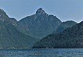
 South aspect | |
| Highest point | |
| Elevation | 1,996 m (6,549 ft) [1] |
| Prominence | 834 m (2,736 ft) [1] |
| Isolation | 16.75 km (10.41 mi) [1] |
| Listing | Mountains of British Columbia |
| Coordinates | 49°58′07″N123°51′09″W / 49.96861°N 123.85250°W [2] |
| Naming | |
| Etymology | Francis Spencer, 1st Baron Churchill |
| Geography | |
 Mount Churchill Location in British Columbia  Mount Churchill Location in Canada | |
 | |
| Interactive map of Mount Churchill | |
| Location | British Columbia, Canada |
| District | New Westminster Land District |
| Parent range | Coast Mountains |
| Topo map | NTS 92G13 Jervis Inlet [2] |
Mount Churchill is a mountain summit located in British Columbia, Canada. [3]