Since 2016, Mali has been divided into ten regions and one capital district. A reorganization of the country from eight to nineteen regions was passed into law in 2012, but of the new regions, only Taoudénit and Ménaka have begun to be implemented. Each of the regions bears the name of its capital. The regions are divided into 56 cercles. The cercles and the capital district are divided into 703 communes.

Mopti is the fifth administrative region of Mali, covering 79,017 km2. Its capital is the city of Mopti. During the 2012 Northern Mali conflict, the frontier between Southern Mali which is controlled by the central government and the rebel-held North ran through Mopti Region.

Gargando is a small town located in the Tombouctou Region of Mali. The people are mainly from subdivisions of the Kel Ansar tribe. The village has a large number of educated Touareg people.

A Commune is the third level administrative unit in Mali. Mali is divided into eight regions and one capital district (Bamako). These subdivisions bear the name of their principal city. The regions are divided into 49 Cercles. The Cercles and the district are divided into 703 Communes, with 36 Urban Communes and 667 Rural Communes, while some larger Cercles still contain Arrondissements above the Commune level, these are organisational areas with no independent power or office. Rural Communes are subdivided in Villages, while Urban Communes are subdivided into Quartier. Communes usually bear the name of their principal town. The capital, Bamako, consists of six Urban Communes. There were initially 701 communes until the Law No. 01-043 of 7 June 2001 created two new Rural Communes in the desert region in the north east of the country: Alata, Ménaka Cercle in the Gao Region and Intadjedite, Tin-Essako Cercle in the Kidal Region.

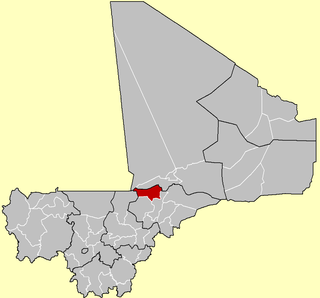
Nioro Cercle is an administrative subdivision of the Kayes Region of Mali. Its administrative center (chef-lieu) is the town of Nioro du Sahel. The commune is on the Mauritanian border and has long been a major stop on the trans-Saharan trade.

Dioïla Cercle is an administrative subdivision of the Koulikoro Region of Mali. Its seat is the town of Dioïla. It lies at the southeast corner of the region, and prior to 1977, it was combined with what is now Kati Cercle and the District of Bamako in the "Bamako Cercle", with the capital city as its seat.

Diamou is a town and commune in the Cercle of Kayes in the Kayes Region of south-western Mali. It is located 45 km from the city of Kayes on the left bank of the Sénégal River. The commune contains 25 villages, and in the 2009 census had a population of 13,793.

Diaye Coura is a small town and commune in the Cercle of Nioro in the Kayes Region of western Mali.

Bla Cercle is an administrative subdivision of the Ségou Region of Mali. The administrative center (chef-lieu) is the town of Bla.

Barouéli Cercle is an administrative subdivision of the Ségou Region of Mali. The administrative center (chef-lieu) is the town of Barouéli.

Macina Cercle is an administrative subdivision of the Ségou Region of Mali. The administrative center (chef-lieu) is the town of Macina.

Ségou Cercle is an administrative subdivision of the Ségou Region of Mali. The administrative center (chef-lieu) is the town of Ségou.

Tominian Cercle is an administrative subdivision of the Ségou Region of Mali. The administrative center of the local government is in the town of Tominian. The Cercle is divided into Communes, and below this, quarters/villages. In the 2009 census the cercle had a population of 219,853 people.

Youwarou Cercle is an administrative subdivision of the Mopti Region of Mali. The administrative center (chef-lieu) is the town of Youwarou.

N'Tjikouna is a village and rural commune in the Cercle of Sikasso in the Sikasso Region of southern Mali. The commune covers an area of 104 square kilometers and includes five villages. In the 2009 census it had a population of 4604. The village of N'Tjikouna, the administrative center (chef-lieu) of the commune, is 66 km southwest of Sikasso.

Blendio is a small town and rural commune in the Cercle of Sikasso in the Sikasso Region of southern Mali. The commune covers an area of 369 square kilometers and includes the town and 13 villages. In the 2009 census it had a population of 18,207. The town of Blendio, the chef-lieu of the commune, is 81 km west-northwest of Sikasso.

Finkolo Ganadougou is a rural commune in the Cercle of Sikasso in the Sikasso Region of southern Mali. The commune covers an area of 464 square kilometers and includes the 16 villages. In the 2009 census it had a population of 8,498. The main village (chef-lieu) is the village of Finkolo. The village of Finkolo, the chef-lieu of the commune, is 59 km west of Sikasso.

Baya is a rural commune in the Cercle of Yanfolila in the Sikasso Region of southern Mali. The commune covers an area of 128 square kilometers and includes the small towns of Kangaré and Dalabala, three villages and part of Lake Sélingué. In the 2009 census the commune had a population of 33,519. The town of Kangaré, the administrative center (chef-lieu) of the commune, lies to the east of the Sélingué Dam, 52 km north of Yanfolila.

Boky Wéré is a village and rural commune in the Cercle of Macina in the Ségou Region of southern-central Mali. The commune covers an area of approximately 220 square kilometers and includes 14 villages. The commune is bordered to the north by the commune of Monimpébougou, to the east by the commune of Kokry, to the west by the commune of Pogo and to the south by the commune of Kolongo. In the 2009 census the commune had a population of 16,934. The village lies to the north of the Fala de Boky-Wéré, an ancient riverbed that forms part of the Office du Niger irrigation system, and to the south of a large irrigation canal dug in 2009 as part of the Libyan financed Malibya project.


