
Elkhart is a city in Elkhart County, Indiana, United States. The population was 53,923 at the 2020 census. The city is located 15 miles (24 km) east of South Bend, Indiana. It is the most populous city in the Elkhart–Goshen metropolitan area, which in turn is part of the South Bend–Elkhart–Mishawaka combined statistical area, in a region commonly known as Michiana.

Michigan City is a city in LaPorte County, Indiana, United States. It had a population of 32,075 at the 2020 census. Located along Lake Michigan in the Michiana region, the city is about 45 miles (72 km) east of Chicago and is 40 miles (64 km) west of South Bend.

New Carlisle is a town in Olive Township, St. Joseph County, in the U.S. state of Indiana. The population was 1,891, as of the 2020 Census. It is part of the South Bend–Mishawaka, IN-MI, Metropolitan Statistical Area.

South Bend is a city in and the county seat of St. Joseph County, Indiana, United States, on the St. Joseph River near its southernmost bend, from which it derives its name. At the 2020 census, the city had a total of 103,453 residents and is the fourth-largest city in Indiana. Located just south of the border with Michigan, South Bend anchors the Michiana region and is 72 miles (116 km) east of downtown Chicago. The metropolitan area had a population of 324,501 in 2020, while its combined statistical area had 812,199.

Michiana is a region in northern Indiana and southwestern Michigan centered on the city of South Bend, Indiana. The Chamber of Commerce of St. Joseph County, Indiana defines Michiana as St. Joseph County and "counties that contribute at least 500 inbound commuting workers to St. Joseph County daily." Those counties include Elkhart, La Porte, Marshall, St. Joseph, and Starke in Indiana, and Berrien and Cass in Michigan. As of the 2020 census, those seven counties had a population of 867,747.
The Lake Shore and Michigan Southern Railway, established in 1833, and sometimes referred to as the Lake Shore, was a major part of the New York Central Railroad's Water Level Route from Buffalo, New York, to Chicago, Illinois, primarily along the south shore of Lake Erie and across northern Indiana. The line's trackage remains a major rail transportation corridor used by Amtrak passenger trains and several freight lines; in 1998, its ownership was split at Cleveland, Ohio, between CSX Transportation to the east and Norfolk Southern Railway in the west.
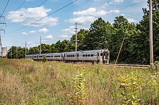
The South Shore Line is an electrically powered interurban commuter rail line operated by the Northern Indiana Commuter Transportation District (NICTD) between Millennium Station in downtown Chicago, Illinois and the South Bend International Airport in South Bend, Indiana, United States. The name refers to both the physical line and the service operated over that route. The line was built in 1901–1908 by predecessors of the Chicago South Shore and South Bend Railroad, which continues to operate freight service. Passenger operation was assumed by the NICTD in 1989, who also purchased the track in 1990. The South Shore Line is one of the last surviving interurban trains in the United States. In 2023, the system had a ridership of 1,406,900, or about 6,300 per weekday as of the third quarter of 2024.

The Chicago South Shore and South Bend Railroad, also known as the South Shore Line, is a Class III freight railroad operating between Chicago, Illinois, and South Bend, Indiana. The railroad serves as a link between Class I railroads and local industries in northeast Illinois and northwest Indiana. It built the South Shore Line electric interurban and operated it until 1990, when the South Shore transferred its passenger operations to the Northern Indiana Commuter Transportation District. The freight railroad is owned by the Anacostia Rail Holdings Company.

Central Station was an intercity passenger terminal in downtown Chicago, Illinois, at the southern end of Grant Park near Roosevelt Road and Michigan Avenue. Owned by the Illinois Central Railroad, it also served other companies via trackage rights. It opened in 1893, replacing Great Central Station, and closed in 1972 when Amtrak rerouted services to Union Station. The station building was demolished in 1974. It is now the site of a redevelopment called Central Station, Chicago.
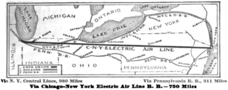
The Chicago – New York Electric Air Line Railroad (CNY) was a proposed high-speed electric air-line railroad between Chicago and New York City in the early 20th century. At roughly 750 miles (1,210 km) it would have been over 150 miles (240 km) shorter than the two primary steam railroads on that route, the New York Central Railroad and Pennsylvania Railroad. The promoters' vision proved wildly optimistic and, in the end, only a short interurban route in the vicinity of Gary, Indiana was built and operated. It was the most ambitious of several such proposals at the dawn of electric railroading, all of which ended in failure.

State Road 4 is an east–west discontinuous state road in the US state of Indiana. The western end of the western segment is in La Porte. The highway passes through rural areas of LaPorte and St. Joseph counties, before ending near Lakeville. The central segment starts at the eastern city limits of Goshen and heads east passing through rural Elkhart County, before ending at SR 13. The eastern segment runs between SR 327 and Interstate 69 (I-69), passing through the towns of Ashley. The state road runs through five counties in northern Indiana mostly through rural farm fields and small towns.

State Road 933 (SR 933) is an Indiana State Road that runs between Elkhart and South Bend in US state of Indiana. The 16.83 miles (27.09 km) of SR 933 that lie within the state serve as a major conduit. None of the highway is listed on the National Highway System. Various sections are urban two-lane highway and urbanized four-lane divided highway. The highway passes through residential and commercial properties.
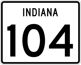
State Road 104 (SR 104) is a state road in the northern section of the US state of Indiana. It serves as a connector between SR 4 near Stillwell to U.S. Route 6 in Walkerton. The highway runs parallel to a rail line in a northwest-to-southeast direction in rural LaPorte and St. Joseph counties. SR 104 dates back to the 1940s.
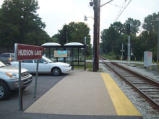
Hudson Lake is a train stop operated by the South Shore Line in the unincorporated community of Hudson Lake, Indiana. It is one of a very few interurban stations located in a rural region of the United States, being located approximately halfway between the much larger communities of Michigan City and South Bend. The station is composed of a passenger shelter, a sign, a small concrete pad, and a small parking lot. As of 2021, the Hudson Lake station is a flag stop. A customer seeking to board the train here must push a button to activate a flashing strobe light that will catch the attention of the train engineer.

U.S. Route 20 (US 20) in Indiana is a main east–west highway that is parallel to the Indiana Toll Road. The western terminus of US 20 is at the Illinois state line and the eastern terminus is at the Ohio state line. US 20 through Whiting, East Chicago, and Gary is concurrent with US 12 twice. The route varies between one-way, two-lane, and four-lane streets, in Northwest Indiana. From the east side of Gary to west of South Bend, US 20 is a four-lane undivided highway. The route then heads around the west and south sides of South Bend and Elkhart as a four-lane limited access divided highway. East of State Road 15 (SR 15), US 20 is two-lane rural highway.

The Great Lakes Circle Tour is a designated scenic road system connecting all of the Great Lakes and the St. Lawrence River. It consists of routes for circumnavigating the lakes, either individually or collectively. It was designated by the Great Lakes Commission in 1988.
Lydick is an unincorporated community in Warren Township, St. Joseph County, in the U.S. state of Indiana.

Springville is an unincorporated community in Springfield Township in northern LaPorte County, Indiana, at the intersection of U.S. Route 20 and Indiana Route 39, less than one mile north of the LaPorte exit on the Indiana Toll Road. It took its name from a large spring that formerly flowed near the town.
New Carlisle was a South Shore Line flag stop located at the corner of Arch and Zigler Streets in New Carlisle, Indiana. The station opened c. 1908 and was built by the Chicago, South Bend and Northern Indiana Railway whose line was immediately north of the South Shore Line. Both lines used the station until the Northern Indiana Railway abandoned its South Bend–Michigan City line leaving the South Shore as the sole occupant. The station remained in service on the South Shore Line until July 5, 1994, when it was closed as part of an NICTD service revision which also saw the closure of Ambridge, Kemil Road, Willard Avenue, LaLumiere, and Rolling Prairie.


