New South Head Road, Sydney

Last updated

New South Head Road

Double Bay, Sydney.jpg
New South Head Road, Double Bay
Location map Australia Sydney.png
Red pog.svg
Southwest end
Red pog.svg
Northeast end
Coordinates
General information
Type Road
Length6.8 km (4.2 mi) [1]
Former
route number
Australian state route 76.svg State Route 76 (1976–2004)
Major junctions
Southwest end William Street
Bayswater Road
Rushcutters Bay, Sydney
 
  • Ocean Street
  • Bellevue Road
  • O'Sullivan Road
  • Hopetoun Avenue
Northeast end Old South Head Road
Vaucluse, Sydney
Location(s)
LGA(s) Municipality of Woollahra
Major suburbs Edgecliff, Double Bay, Point Piper, Rose Bay

New South Head Road, is a major road in the Eastern Suburbs of Sydney. The road runs north-east from Rushcutters Bay through Edgecliff, Double Bay, Point Piper, Rose Bay and Vaucluse where it finally merges into Old South Head Road.

Contents

History

Maroo track

Prior to the road's construction the main route to the southern headland was South Head Road, which led to the signal station following the route of modern-day Old South Head Road and Oxford Street. In 1831, construction began on New South Head Road. The road was to follow the route of the Aboriginal foot track Maroo, which contoured between south head and Sydney. Before construction began on New South Head Road, only Aborigines and men stationed at the South Head Lookout Post used the track.

Initial completion

The Remains of Bentley's Bridge today Bentley's Bridge.jpg
The Remains of Bentley's Bridge today

For the first few years of construction progress was slow and only parts of the road began to develop, as work was treacherous with the route offering a range of harsh environments such as the low lying swamplands of Rushcutters Bay, Double Bay and Rose Bay, to the steep cliff faces of Vaucluse and Watsons Bay; in addition, the bush lands surrounding the Maroo Track were reportedly infested with snakes. However, by 1834 efforts had increased, and the road began to take shape. Where the road crosses Rushcutters Creek, a succession of bridges were built, starting with a timber bridge around 1834, followed by a stone bridge erected between 1837 and 1839. Bentley's Bridge, [2] as it came to be known, was built by convicts under supervision of Lieutenant ACD Bentley. By the late 1830s, the road was able to cater for carts and stretched from Rushcutters Bay to Vaucluse, finally providing Sydneysiders a coastal thoroughfare along the southern banks of the harbour.

South Head Road's Trust

Due to the poor condition of the New South Head Road and its southern predecessor Old South Head Road a trust was set up by a government act in May 1848. The trust had the responsibility of maintaining the twenty four kilometres of road under its control. To raise the funds to maintain the roads the Trust set up tolls, one of which was located on New South Head Road in the form of a turnpike gate that extracted tolls from the road users. Unfortunately for the occupants of newly developed suburbs on South Head such as Vaucluse, the trust failed to adequately delegate funds and maintenance of the road remained poor until the trust was disbanded in 1904.

Growing importance

After the completion of New South Head Road, suburbs quickly formed around the road creating a demand for public and private services. In the late nineteenth century a number of schools were established on the road including the Sacred Heart Convent, now Kincoppal, Rose Bay (1882), Kambala School (1884), Ascham School (1886) and Cranbrook School established twenty years later in Rose Bay. As well as this a Roman Catholic church, St. Mary Magdalene, was built in Rose Bay in 1920. Official Government buildings were also established on the road including the Rose Bay Police Station (1930) and the Woollahra Council Chambers in Double Bay (1947). Also a number of recreational facilities were installed along the route including parks, yacht clubs and the Royal Sydney Golf Club (1896).

Expansion

By the early 1930s New South Head Road had become a major route as it linked the wealthy suburbs on the harbour foreshore to Sydney's centre. The road had developed little since its initial completion and its condition had severely worsened since the disbanding of the Old South Head Road's Trust in 1904, so in 1932 a major redevelopment of the road began which included widening the road to cater for modern day motor vehicles. The widening of the road required the creation of seawalls in Rose Bay and Rushcutters Bay, whilst the Rose Bay sea wall had been mainly developed in 1928, the Rushcutters Bay sea wall wasn't completed until later in 1932. The road was again widened in the late 1970s and early 1980s to four lanes (two each way).

Trams

In the late nineteenth century a tram line was added to New South Head Road. The Watson's Bay line began at Wynyard and reached New South Head Road at its starting point in Rushcutters Bay, where a tram depot serving the line was located on the north side of the road. The line was expanded along New South Head Road to Edgecliff in 1894 and reached Watson's Bay in 1909. The line left New South Head Road in Vaucluse as it became a single track down to Watson's Bay. The track was centralized in the late 1920s and early 1930s with the widening of New South Head Road. In 1949, the line from Rose Bay to Watson's Bay was closed, but reopened due to public protest in 1950, though was later along with the rest of the line permanently closed in 1960.

Present day

Today the road serves as a major link to the city from the predominantly upper and middle class suburbs of the Woollahra municipality. The road is often heavily congested with cars especially during peak hours. The road is serviced by a number of bus routes connecting the Sydney CBD to Vaucluse, Watsons Bay and Dover Heights. There is a major bus interchange and train station located on the road in Edgecliff. The Watson's Bay Ferry Route has stops off the road in Rose Bay and Double Bay, providing a popular and quicker option for businesspersons in the area to commute to the city. The road also serves as the major leg of the Sydney City to Surf running event, and is famous for the steep ascent from Rose Bay to Vaucluse known as Heartbreak Hill. [3]

See also

Australia road sign W5-29.svg   Australian Roadsportal

Related Research Articles

Rose Bay, New South Wales Suburb of Sydney, New South Wales, Australia

Rose Bay is a harbourside, eastern suburb of Sydney, in the state of New South Wales, Australia. Rose Bay is located seven kilometres east of the Sydney central business district, in the local government areas of Waverley Council and Municipality of Woollahra.

Eastern Suburbs (Sydney) Region in New South Wales, Australia

The Eastern Suburbs is the metropolitan region directly to the east and south-east of the central business district in Sydney, New South Wales, Australia.

Bondi Junction railway station

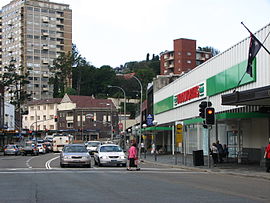
Bondi Junction railway station is located on the Eastern Suburbs line, serving the Sydney suburb of Bondi Junction. It is served by Sydney Trains T4 Eastern Suburbs & Illawarra Line services and NSW TrainLink South Coast Line services.

Eastern Suburbs railway line

The Eastern Suburbs Railway is a commuter railway line in Sydney constructed in the 1970s. It is operated by Sydney Trains and has stations at Martin Place, Kings Cross, Edgecliff and Bondi Junction. In addition, it has dedicated platforms at Town Hall, Central and Redfern stations. All of these stations are underground. The Eastern Suburbs railway connects with the Illawarra line at Erskineville, forming the Eastern Suburbs & Illawarra Line. The line features turnbacks at Central, Martin Place and Bondi Junction. There is also a rarely used cross-over or 'turnout' at Edgecliff. It operates a service every 3 to 5 minutes during weekday peak hours and 8 to 10 minutes at all other times.

Woollahra, New South Wales Suburb of Sydney, New South Wales, Australia

Woollahra is a suburb in the Eastern Suburbs of Sydney, in the state of New South Wales, Australia. Woollahra is located 5 kilometres east of the Sydney central business district, in the local government area of the Municipality of Woollahra. Woollahra is located on the traditional land of the Birrabirragal and Gadigal people of the Eora Nation. The Municipality of Woollahra takes its name from the suburb but its administrative centre is located in Double Bay. Woollahra is famous for its quiet, tree-lined residential streets and village-style shopping centre.

Paddington, New South Wales Suburb of Sydney, New South Wales, Australia

Paddington is an inner-city area of Sydney, in the state of New South Wales, Australia. Located 3 kilometres (1.9 mi) east of the Sydney central business district, Paddington lies across two local government areas. The portion south of Oxford Street lies within the City of Sydney, while the portion north of Oxford Street lies within the Municipality of Woollahra. It is often colloquially referred to as "Paddo".

Bellevue Hill, New South Wales Suburb of Sydney, New South Wales, Australia

Bellevue Hill is a harbourside eastern suburb of Sydney, in the state of New South Wales, Australia, located 5 kilometres east of the Sydney central business district, in the Municipality of Woollahra.

Division of Wentworth Australian federal electoral division

The Division of Wentworth is an Australian electoral division in the state of New South Wales.

Watsons Bay, New South Wales Suburb of Sydney, New South Wales, Australia

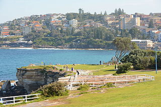
Watsons Bay is a harbourside, eastern suburb of Sydney, in the state of New South Wales, Australia. Watsons Bay is located 11 km north-east of the Sydney central business district, in the local government area of the Municipality of Woollahra.

Vaucluse, New South Wales Suburb of Sydney, New South Wales, Australia

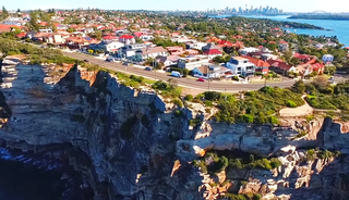
Vaucluse is an eastern suburb of Sydney, in the state of New South Wales, Australia. It is located 8 kilometres (5 mi) north-east of the Sydney central business district, in the local government areas of Waverley Council and the Municipality of Woollahra.

Edgecliff, New South Wales Suburb of Sydney, New South Wales, Australia

Edgecliff is a small suburb in the Eastern Suburbs of Sydney, in the state of New South Wales, Australia. Edgecliff is located 4 kilometres east of the Sydney central business district, in the local government area of the Municipality of Woollahra. The postcode is 2027.

Municipality of Woollahra Local government area in New South Wales, Australia

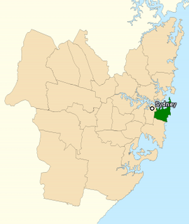
Woollahra Municipal Council is a local government area in the eastern suburbs of Sydney, in the state of New South Wales, Australia. Woollahra is bounded by Sydney Harbour in the north, Waverley Council in the east, Randwick City in the south and the City of Sydney in the west.

Edgecliff railway station

Edgecliff railway station is located on the Eastern Suburbs line, serving the Sydney suburb of Edgecliff. It is served by Sydney Trains T4 Eastern Suburbs & Illawarra Line services and NSW TrainLink South Coast Line services.

Darling Point, New South Wales Suburb of Sydney, New South Wales, Australia

Darling Point is a harbourside eastern suburb of Sydney, Australia. It is 4 kilometres east of the Sydney central business district and is part of the local government area of Woollahra Council.

Sydney Stadium Sporting and entertainment venue in Sydney

The Sydney Stadium was a sporting and entertainment venue in Sydney, New South Wales, which formerly stood on the corner of New South Head Road and Neild Avenue, Rushcutters Bay. Built in 1908, it was demolished in 1970 to make way for the construction of the Eastern Suburbs Railway.

William Street, Sydney Road in Sydney, Australia

William Street is a 1.4-kilometre-long (0.87 mi) major thoroughfare in Sydney, New South Wales, Australia.

Woollahra railway station

Woollahra railway station was a proposed railway station on Sydney's Eastern Suburbs line. Named after the suburb it was located in, Woollahra railway station would have been built between the present stations of Edgecliff and Bondi Junction. The proposed site of the station currently exists as a cutting off Edgecliff Road. Had this station been completed, it would have been the only above-ground station on the line. Opposition from local residents and costs associated with the construction of the Eastern Suburbs railway prevented the station from being opened.

Old South Head Road, Sydney Road in Sydney, Australia

Old South Head Road is a road in Sydney which goes from the suburb of Bondi Junction to Watsons Bay. It also passes through Bondi, Bondi Beach, North Bondi, Rose Bay and Vaucluse. It is historically significant because its earliest origins can be traced back to the early days of the colony. The road goes through the local government areas of Waverley Council and the Municipality of Woollahra. It is 6.8 kilometres long.

Rose Bay Sea Wall

Rose Bay Sea Wall is a heritage-listed former Aboriginal land, farms and road reserve and now sea wall, road reserve and esplanade at New South Head Road, Rose Bay, in the Municipality of Woollahra local government area of New South Wales, Australia. It was designed by Herbert E. Ross and built from 1924 to 1926 by Woollahra Municipal Council. It is also known as Rose Bay Sea Wall, Promenade and its setting. It was added to the New South Wales State Heritage Register on 22 August 2014.

<i>Vaucluse</i> (ferry)

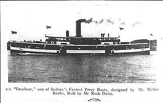
Vaucluse was a ferry on Sydney Harbour that served on the Circular Quay to Watsons Bay run. She was launched in 1905, and was one of the fastest ferries in Sydney. She was sent to Newcastle after which her fate is unknown.

References

  1. Google (28 May 2015). "New South Head Road, Sydney" (Map). Google Maps . Google. Retrieved 28 May 2015.
  2. "Bentleys Bridge". Heritage and Conservation Register. Roads and Traffic Authority . Retrieved 16 April 2007.
  3. "Interactive Map Video 2". City to Surf website. The Sydney Morning Herald. 2006. Archived from the original (movie) on 2 April 2007. Retrieved 12 April 2007.